


<< Our Photo Pages >> Hoher Stein (bei Suttrop) - Cave or Rock Shelter in Germany in North Rhine-Westphalia
Submitted by Andreas on Thursday, 20 May 2010 Page Views: 4548
Mesolithic, Palaeolithic and EarlierSite Name: Hoher Stein (bei Suttrop) Alternative Name: Hoher Stein (bei Kallenhardt)Country: Germany
NOTE: This site is 3.178 km away from the location you searched for.
Land: North Rhine-Westphalia Type: Cave or Rock Shelter
Nearest Town: Warstein Nearest Village: Suttrop
Latitude: 51.439500N Longitude: 8.395100E
Condition:
| 5 | Perfect |
| 4 | Almost Perfect |
| 3 | Reasonable but with some damage |
| 2 | Ruined but still recognisable as an ancient site |
| 1 | Pretty much destroyed, possibly visible as crop marks |
| 0 | No data. |
| -1 | Completely destroyed |
| 5 | Superb |
| 4 | Good |
| 3 | Ordinary |
| 2 | Not Good |
| 1 | Awful |
| 0 | No data. |
| 5 | Can be driven to, probably with disabled access |
| 4 | Short walk on a footpath |
| 3 | Requiring a bit more of a walk |
| 2 | A long walk |
| 1 | In the middle of nowhere, a nightmare to find |
| 0 | No data. |
| 5 | co-ordinates taken by GPS or official recorded co-ordinates |
| 4 | co-ordinates scaled from a detailed map |
| 3 | co-ordinates scaled from a bad map |
| 2 | co-ordinates of the nearest village |
| 1 | co-ordinates of the nearest town |
| 0 | no data |
Internal Links:
External Links:
I have visited· I would like to visit
Andreas has visited here
 (PID:57647)")
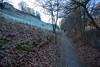
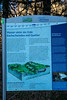
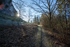
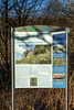
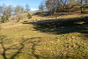
It's the remain of a formerly larger rock that consists of reef lime from middle Devonian. Due to quarry activities the rock has been heavily damaged and reduced. But it's still an impressive site. And nowadays the remaining rock, including its neighbourhood, is protected as a part of a nature reserve.
The site still contains at least three known caves, named as Rissehöhle, Hundehöhle and Schnöpers Huol. All of them have more or less collapsed.
The only accessible specimen, a miniature-cave directly at Hoher Stein, is more a large crevice than a real cave. But it's easily accessible. And it's almost comfortable. Perhaps already some stone age people may have used it as a shelter.
Indeed some traces of paleolithic and/or mesolithic men have been found about 250 metres southeast of the rock.
Reference:
H.Streich: Unterirdische Zauberreiche des Sauerlandes, Altena 1967
You may be viewing yesterday's version of this page. To see the most up to date information please register for a free account.
 (PID:57646)")
 (PID:57645)")
 (PID:57648)")
Do not use the above information on other web sites or publications without permission of the contributor.
Nearby Images from Flickr

The above images may not be of the site on this page, but were taken nearby. They are loaded from Flickr so please click on them for image credits.
Click here to see more info for this site
Nearby sites
Click here to view sites on an interactive map of the areaKey: Red: member's photo, Blue: 3rd party photo, Yellow: other image, Green: no photo - please go there and take one, Grey: site destroyed
Download sites to:
KML (Google Earth)
GPX (GPS waypoints)
CSV (Garmin/Navman)
CSV (Excel)
To unlock full downloads you need to sign up as a Contributory Member. Otherwise downloads are limited to 50 sites.
Turn off the page maps and other distractions
Nearby sites listing. In the following links * = Image available
635m ESE 123° Hohler Stein bei Kallenhardt* Cave or Rock Shelter
3.9km NE 55° Wallburg Schaftsköppen* Hillfort
6.6km NW 323° Summstein Belecke Modern Stone Circle etc
10.2km S 186° Veledahöhle* Cave or Rock Shelter
10.2km NNW 327° Uelde Galeriegrab Chambered Tomb
10.6km SSE 160° Bronze Urn of Gevelinghausen* Round Barrow(s)
12.9km ESE 113° Brilon Furchensteine* Polissoir
15.0km S 179° Venetianer-Stollen* Ancient Mine, Quarry or other Industry
15.5km ESE 116° Summstein Hängeberg Modern Stone Circle etc
16.2km SW 230° Stesser Burg* Hillfort
16.6km SE 142° Ewige Quelle* Holy Well or Sacred Spring
16.6km SE 141° Bruchhauser Steine.* Rock Outcrop
16.8km SE 141° Wallburg Bruchhauser Steine* Hillfort
16.8km SE 130° Kleinenberg Menhir* Standing Stone (Menhir)
17.3km SSE 150° Strücker Stein* Rock Outcrop
18.6km NNW 339° Völlinghausen Galeriegrab Chambered Tomb
19.2km NNW 336° Völlinghausen Chambered Tomb
19.4km E 100° Hollenloch* Cave or Rock Shelter
20.3km NNW 327° Schmerlecke (1) Chambered Tomb
20.4km NW 318° Erdwerk Bad Sassendorf Misc. Earthwork
20.4km NW 326° Nasenstein* Standing Stone (Menhir)
20.5km NNW 328° Schmerlecke Galeriegrab (3) Passage Grave
20.6km NNW 328° Schmerlecke (2) Chambered Tomb
21.2km E 87° Madfeld Iron Age Settlement and Forge Ancient Village or Settlement
21.7km NE 44° Brenken Galeriegrab Chambered Tomb
View more nearby sites and additional images


 We would like to know more about this location. Please feel free to add a brief description and any relevant information in your own language.
 Wir möchten mehr über diese Stätte erfahren. Bitte zögern Sie nicht, eine kurze Beschreibung und relevante Informationen in Deutsch hinzuzufügen.
 Nous aimerions en savoir encore un peu sur les lieux. S'il vous plaît n'hesitez pas à ajouter une courte description et tous les renseignements pertinents dans votre propre langue.
 Quisieramos informarnos un poco más de las lugares. No dude en añadir una breve descripción y otros datos relevantes en su propio idioma.