

<< Text Pages >> Ballindoon Priory Ballaun Stone - Early Christian Sculptured Stone in Ireland (Republic of) in Co. Sligo
Submitted by littlemark on Monday, 31 July 2023 Page Views: 148
Early Medieval (Dark Age)Site Name: Ballindoon Priory Ballaun StoneCountry: Ireland (Republic of)
NOTE: This site is 9.939 km away from the location you searched for.
County: Co. Sligo Type: Early Christian Sculptured Stone
Nearest Village: Ballindoon
Latitude: 54.082980N Longitude: 8.323240E
Condition:
| 5 | Perfect |
| 4 | Almost Perfect |
| 3 | Reasonable but with some damage |
| 2 | Ruined but still recognisable as an ancient site |
| 1 | Pretty much destroyed, possibly visible as crop marks |
| 0 | No data. |
| -1 | Completely destroyed |
| 5 | Superb |
| 4 | Good |
| 3 | Ordinary |
| 2 | Not Good |
| 1 | Awful |
| 0 | No data. |
| 5 | Can be driven to, probably with disabled access |
| 4 | Short walk on a footpath |
| 3 | Requiring a bit more of a walk |
| 2 | A long walk |
| 1 | In the middle of nowhere, a nightmare to find |
| 0 | No data. |
| 5 | co-ordinates taken by GPS or official recorded co-ordinates |
| 4 | co-ordinates scaled from a detailed map |
| 3 | co-ordinates scaled from a bad map |
| 2 | co-ordinates of the nearest village |
| 1 | co-ordinates of the nearest town |
| 0 | no data |
Internal Links:
External Links:
Early Christian Sculptured Stone in Co. Sligo
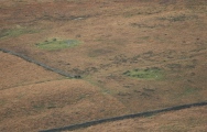
Ballaun Stone atop a fragment of field wall close to the ruins of nearby Ballindoon Dominican Priory. The depression in the stone’s top is usually filled with water and is believed to cure warts.
You may be viewing yesterday's version of this page. To see the most up to date information please register for a free account.
Do not use the above information on other web sites or publications without permission of the contributor.
Nearby Images from Flickr

The above images may not be of the site on this page, but were taken nearby. They are loaded from Flickr so please click on them for image credits.
Click here to see more info for this site
Nearby sites
Click here to view sites on an interactive map of the areaKey: Red: member's photo, Blue: 3rd party photo, Yellow: other image, Green: no photo - please go there and take one, Grey: site destroyed
Download sites to:
KML (Google Earth)
GPX (GPS waypoints)
CSV (Garmin/Navman)
CSV (Excel)
To unlock full downloads you need to sign up as a Contributory Member. Otherwise downloads are limited to 50 sites.
Turn off the page maps and other distractions
Nearby sites listing. In the following links * = Image available
30.1km SE 140° Grabhügelgruppe Am Kirchhof* Barrow Cemetery
30.2km SE 140° Duhnen Ringwall* Henge
30.2km SE 140° Twellberg Grabhuegel* Round Barrow(s)
30.2km SE 140° Grabhügel Twellberg II* Round Barrow(s)
30.4km SE 142° Grabhügel Duhnen FstNr. 101 Round Barrow(s)
30.4km SE 140° Grabhügel am Scharmoorweg* Round Barrow(s)
30.5km SE 143° Grabhügel Wittenhöhen und Urnenfriedhof Barrow Cemetery
30.6km SE 141° Grabhügelgruppe Scharmoor (II)* Barrow Cemetery
30.6km SE 141° Grabhügelgruppe Scharmoor (I) Barrow Cemetery
30.6km WNW 292° Museum Helgoland* Museum
30.9km WNW 291° Helgoland Steinkiste* Cist
31.6km SE 143° Grabhügel am Feuerberg* Round Barrow(s)
31.6km SE 139° Grabhügel Silberberg Round Barrow(s)
31.6km SE 139° Grabhügel A beim Galgenberg* Round Barrow(s)
31.6km SE 139° Grabhügel B/C beim Galgenberg* Round Barrow(s)
31.6km SE 142° Grabhügel Sahlenburg FsNr. 80* Round Barrow(s)
31.7km SE 143° Grabhügel Sahlenburg FsNr. 82* Round Barrow(s)
31.7km SE 139° Cuxhaven Galgenberg* Round Barrow(s)
31.7km SE 142° Grabhügel Sahlenburg FsNr. 79 Round Barrow(s)
31.7km SE 142° Feuerberg (Bauernwald)* Round Barrow(s)
31.7km SE 142° Grabhügel Sahlenburg FsNr. 81 Round Barrow(s)
32.3km SE 146° Grabhügel Wolfsberg* Round Barrow(s)
32.3km SE 142° Sahlenburg Achtern Kugelfang Huegelgraeberfeld* Barrow Cemetery
32.9km SE 141° Spanger Berg* Round Barrow(s)
33.1km SE 144° Kahleberg Huegelgrab* Round Barrow(s)
View more nearby sites and additional images


 We would like to know more about this location. Please feel free to add a brief description and any relevant information in your own language.
 Wir möchten mehr über diese Stätte erfahren. Bitte zögern Sie nicht, eine kurze Beschreibung und relevante Informationen in Deutsch hinzuzufügen.
 Nous aimerions en savoir encore un peu sur les lieux. S'il vous plaît n'hesitez pas à ajouter une courte description et tous les renseignements pertinents dans votre propre langue.
 Quisieramos informarnos un poco más de las lugares. No dude en añadir una breve descripción y otros datos relevantes en su propio idioma.