


<< Our Photo Pages >> Ancient Cross Gauersheim - Ancient Cross in Germany in Rhineland-Palatinate
Submitted by KaiHofmann on Wednesday, 11 December 2013 Page Views: 1387
Early Medieval (Dark Age)Site Name: Ancient Cross GauersheimCountry: Germany
NOTE: This site is 2.195 km away from the location you searched for.
Land: Rhineland-Palatinate Type: Ancient Cross
Nearest Town: Bischheim Nearest Village: Gauersheim
Latitude: 49.670260N Longitude: 8.075200E
Condition:
| 5 | Perfect |
| 4 | Almost Perfect |
| 3 | Reasonable but with some damage |
| 2 | Ruined but still recognisable as an ancient site |
| 1 | Pretty much destroyed, possibly visible as crop marks |
| 0 | No data. |
| -1 | Completely destroyed |
| 5 | Superb |
| 4 | Good |
| 3 | Ordinary |
| 2 | Not Good |
| 1 | Awful |
| 0 | No data. |
| 5 | Can be driven to, probably with disabled access |
| 4 | Short walk on a footpath |
| 3 | Requiring a bit more of a walk |
| 2 | A long walk |
| 1 | In the middle of nowhere, a nightmare to find |
| 0 | No data. |
| 5 | co-ordinates taken by GPS or official recorded co-ordinates |
| 4 | co-ordinates scaled from a detailed map |
| 3 | co-ordinates scaled from a bad map |
| 2 | co-ordinates of the nearest village |
| 1 | co-ordinates of the nearest town |
| 0 | no data |
Internal Links:
External Links:
")
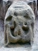
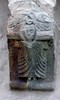
A small early cross, close to a road.
You may be viewing yesterday's version of this page. To see the most up to date information please register for a free account.
")
")
")
Do not use the above information on other web sites or publications without permission of the contributor.
Nearby Images from Flickr
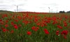
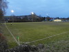
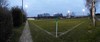
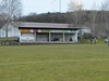
The above images may not be of the site on this page, but were taken nearby. They are loaded from Flickr so please click on them for image credits.
Click here to see more info for this site
Nearby sites
Click here to view sites on an interactive map of the areaKey: Red: member's photo, Blue: 3rd party photo, Yellow: other image, Green: no photo - please go there and take one, Grey: site destroyed
Download sites to:
KML (Google Earth)
GPX (GPS waypoints)
CSV (Garmin/Navman)
CSV (Excel)
To unlock full downloads you need to sign up as a Contributory Member. Otherwise downloads are limited to 50 sites.
Turn off the page maps and other distractions
Nearby sites listing. In the following links * = Image available
1.3km WSW 254° Hunkelstein Standing Stone (Menhir)
1.8km WNW 283° Rittersheim Lange Stein* Standing Stone (Menhir)
4.5km ESE 107° Einselthum Kenotaph Chambered Tomb
4.5km ESE 105° Einselthum Lange Stein* Standing Stone (Menhir)
5.0km ESE 118° Zell (Pfalz/Palatinate)* Natural Stone / Erratic / Other Natural Feature
5.1km WSW 238° Bolanden Hinkelstein* Standing Stone (Menhir)
5.8km SW 231° Grabstelen Bolanden* Standing Stones
6.7km NW 309° Vorholz Grabhuegelgruppe Barrow Cemetery
7.3km SW 226° Hinkelstein Weierhof* Standing Stone (Menhir)
7.7km ENE 59° Dicker Stein Eppelsheim Standing Stone (Menhir)
7.9km NW 304° Vorholz Kreisgrabenanlage Henge
8.8km NE 40° Dautenheim Hinkelstein * Standing Stone (Menhir)
8.8km NE 40° Steinkreis Dautenheim* Stone Circle
9.6km E 94° Hinkelstein Flörsheim Standing Stone (Menhir)
9.9km ESE 112° Monsheim Hinkelstein* Standing Stone (Menhir)
10.1km ESE 111° Steinernes Kreuz Monsheim* Ancient Cross
10.1km SE 138° Katzenstein Bockenheim* Natural Stone / Erratic / Other Natural Feature
10.2km NNW 328° Nack Monolith* Standing Stone (Menhir)
10.2km SE 138° Quelle Heiligenkirche* Holy Well or Sacred Spring
11.2km WSW 247° Hinkelstein Donnersberg* Standing Stone (Menhir)
11.7km WSW 245° Donnersberg (Dannenfels)* Ancient Village or Settlement
12.2km SW 227° Keltendorf Steinbach* Museum
12.8km SE 145° Albsheim Menhir* Standing Stone (Menhir)
13.3km SW 220° Bocksrück Wald Grabhügelfeld Barrow Cemetery
13.4km N 356° Langer Stein Flonheim* Standing Stone (Menhir)
View more nearby sites and additional images


 We would like to know more about this location. Please feel free to add a brief description and any relevant information in your own language.
 Wir möchten mehr über diese Stätte erfahren. Bitte zögern Sie nicht, eine kurze Beschreibung und relevante Informationen in Deutsch hinzuzufügen.
 Nous aimerions en savoir encore un peu sur les lieux. S'il vous plaît n'hesitez pas à ajouter une courte description et tous les renseignements pertinents dans votre propre langue.
 Quisieramos informarnos un poco más de las lugares. No dude en añadir una breve descripción y otros datos relevantes en su propio idioma.