 with our Megalithic Portal iPhone app")
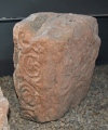

<< Our Photo Pages >> Fliegenstein von Wattenheim - Standing Stone (Menhir) in Germany in Rhineland-Palatinate
Submitted by AlexHunger on Monday, 10 October 2005 Page Views: 6333
Neolithic and Bronze AgeSite Name: Fliegenstein von Wattenheim Alternative Name: Wattenheim FürstengrabhügelCountry: Germany
NOTE: This site is 2.745 km away from the location you searched for.
Land: Rhineland-Palatinate Type: Standing Stone (Menhir)
Nearest Town: Eisenberg Nearest Village: Wattenheim
Latitude: 49.522952N Longitude: 8.044132E
Condition:
| 5 | Perfect |
| 4 | Almost Perfect |
| 3 | Reasonable but with some damage |
| 2 | Ruined but still recognisable as an ancient site |
| 1 | Pretty much destroyed, possibly visible as crop marks |
| 0 | No data. |
| -1 | Completely destroyed |
| 5 | Superb |
| 4 | Good |
| 3 | Ordinary |
| 2 | Not Good |
| 1 | Awful |
| 0 | No data. |
| 5 | Can be driven to, probably with disabled access |
| 4 | Short walk on a footpath |
| 3 | Requiring a bit more of a walk |
| 2 | A long walk |
| 1 | In the middle of nowhere, a nightmare to find |
| 0 | No data. |
| 5 | co-ordinates taken by GPS or official recorded co-ordinates |
| 4 | co-ordinates scaled from a detailed map |
| 3 | co-ordinates scaled from a bad map |
| 2 | co-ordinates of the nearest village |
| 1 | co-ordinates of the nearest town |
| 0 | no data |
Internal Links:
External Links:
")
Note: If you downloaded the coordinates before 12.10.2011: they referred to a wrong village of same name. Coordinates improved, but still not accurate. The site is said to be North of motorway at edge of wood near minor road from Wattenheim to Lauberhof.
You may be viewing yesterday's version of this page. To see the most up to date information please register for a free account.
")
")
")
")
")
")
")
")
")
")
")
")
")
Do not use the above information on other web sites or publications without permission of the contributor.
Click here to see more info for this site
Nearby sites
Click here to view sites on an interactive map of the areaKey: Red: member's photo, Blue: 3rd party photo, Yellow: other image, Green: no photo - please go there and take one, Grey: site destroyed
Download sites to:
KML (Google Earth)
GPX (GPS waypoints)
CSV (Garmin/Navman)
CSV (Excel)
To unlock full downloads you need to sign up as a Contributory Member. Otherwise downloads are limited to 50 sites.
Turn off the page maps and other distractions
Nearby sites listing. In the following links * = Image available
179m WSW 243° Huegelgraeber Hettenleidelheim* Barrow Cemetery
286m WSW 247° Neun Steine Hettenleidelheim* Stone Circle
6.1km WNW 304° Der Lange Stein Sippersfeld Standing Stone (Menhir)
6.5km ESE 121° Gebetsfelsen Rock Art
6.9km ESE 118° Kanapee* Sculptured Stone
8.9km NW 315° Bocksrück Wald Grabhügelfeld Barrow Cemetery
9.3km WNW 292° Babenstein* Standing Stone (Menhir)
9.4km WNW 288° Gonbach Grabhügelfeld Barrow Cemetery
9.5km SE 127° Teufelsstein (Grethen)* Sculptured Stone
10.2km W 265° Spitzer Huegel Artificial Mound
10.5km NW 320° Keltendorf Steinbach* Museum
10.5km SE 129° Keltenwall Bad Dürkheim* Hillfort
10.6km SE 128° Kriemhildenstuhl* Ancient Mine, Quarry or other Industry
10.8km NW 311° Börrstadt Hinkelstein* Standing Stone (Menhir)
10.9km SE 127° Grabstelen Bad Dürkheim Standing Stones
10.9km WNW 292° Gonbach Langer Stein* Standing Stone (Menhir)
11.1km S 177° Drachenfels* Promontory Fort / Cliff Castle
11.3km ENE 58° Albsheim Menhir* Standing Stone (Menhir)
11.6km NW 311° Pfaffenschlag Graeberfeld Barrow Cemetery
11.7km SE 140° Alte Kelter Rock Art
11.7km NNW 345° Hinkelstein Weierhof* Standing Stone (Menhir)
12.3km W 262° Mehlingerhof Menhir* Standing Stone (Menhir)
12.5km SSW 210° Frankenstein Menhir* Standing Stone (Menhir)
12.6km S 172° Lambertskreuz Ancient Cross
12.6km E 101° Freinsheim Langer Stein* Standing Stone (Menhir)
View more nearby sites and additional images


 We would like to know more about this location. Please feel free to add a brief description and any relevant information in your own language.
 Wir möchten mehr über diese Stätte erfahren. Bitte zögern Sie nicht, eine kurze Beschreibung und relevante Informationen in Deutsch hinzuzufügen.
 Nous aimerions en savoir encore un peu sur les lieux. S'il vous plaît n'hesitez pas à ajouter une courte description et tous les renseignements pertinents dans votre propre langue.
 Quisieramos informarnos un poco más de las lugares. No dude en añadir una breve descripción y otros datos relevantes en su propio idioma.