


<< Our Photo Pages >> Oddernes Runestone - Carving in Norway in Vest-Agder
Submitted by kenntha88 on Wednesday, 25 November 2015 Page Views: 1455
Early Medieval (Dark Age)Site Name: Oddernes RunestoneCountry: Norway
NOTE: This site is 9.817 km away from the location you searched for.
Fylke: Vest-Agder Type: Carving
Nearest Town: Kristiansand
Latitude: 58.159685N Longitude: 8.013325E
Condition:
| 5 | Perfect |
| 4 | Almost Perfect |
| 3 | Reasonable but with some damage |
| 2 | Ruined but still recognisable as an ancient site |
| 1 | Pretty much destroyed, possibly visible as crop marks |
| 0 | No data. |
| -1 | Completely destroyed |
| 5 | Superb |
| 4 | Good |
| 3 | Ordinary |
| 2 | Not Good |
| 1 | Awful |
| 0 | No data. |
| 5 | Can be driven to, probably with disabled access |
| 4 | Short walk on a footpath |
| 3 | Requiring a bit more of a walk |
| 2 | A long walk |
| 1 | In the middle of nowhere, a nightmare to find |
| 0 | No data. |
| 5 | co-ordinates taken by GPS or official recorded co-ordinates |
| 4 | co-ordinates scaled from a detailed map |
| 3 | co-ordinates scaled from a bad map |
| 2 | co-ordinates of the nearest village |
| 1 | co-ordinates of the nearest town |
| 0 | no data |
Internal Links:
External Links:
")
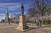
The Oddernes Runestone is a tall and beautiful runestone located in Oddernes church in Kristiansand. The runestone was originally located outside the church some distance to the east but was moved to the inside of the church entrance in 1990.
The runestone is unique since it has two different runic inscriptions believed to be from two different time areas and one of them mentioning St.Olav. The later inscription has probably been added to the already standing runestone long after the first inscription. Both the runic inscriptions are written in the newer futhark and the stone is believed to be from 1000 to 1030AD.
The stone itself is a beautiful standing stone, it is 3,5 metres in height, 65cm wide at the base and around 40 at the top and 17 to 12 cm thick and with a straight cut off top. It has a almost perfect rectangle shaped cross section.
The oldest runic inscription is found on the largest flat surface of the stone and it has been interpreted to mean: "In memory of Nerid stands this stone".
The newest runic inscription is found on the thin side going down the edge of the stone, it has been interpreted as: "Eivind made this church, godson of st.Olav on his land." It is believed to be from the end of the iron age or early middle ages.
You may be viewing yesterday's version of this page. To see the most up to date information please register for a free account.
")
")
")
")
Do not use the above information on other web sites or publications without permission of the contributor.
Nearby Images from Flickr
The above images may not be of the site on this page, but were taken nearby. They are loaded from Flickr so please click on them for image credits.
Click here to see more info for this site
Nearby sites
Click here to view sites on an interactive map of the areaKey: Red: member's photo, Blue: 3rd party photo, Yellow: other image, Green: no photo - please go there and take one, Grey: site destroyed
Download sites to:
KML (Google Earth)
GPX (GPS waypoints)
CSV (Garmin/Navman)
CSV (Excel)
To unlock full downloads you need to sign up as a Contributory Member. Otherwise downloads are limited to 50 sites.
Turn off the page maps and other distractions
Nearby sites listing. In the following links * = Image available
535m NW 321° Pjolterhaugen* Round Barrow(s)
5.1km NE 46° Hamresanden Ancient Village or Settlement
5.6km NE 49° Hamresanden Tingringen* Stone Circle
12.0km WSW 243° Tingsteinen* Ring Cairn
12.7km SW 233° Tangvall cist* Cist
12.8km SW 233° Søgne Runestone* Carving
17.3km WNW 302° Stallemo* Barrow Cemetery
20.6km NNE 30° The Mollestad Oak* Natural Stone / Erratic / Other Natural Feature
21.0km NE 40° Skillsteinene* Stone Row / Alignment
27.2km WSW 242° Harkmark stone circle* Stone Circle
28.3km W 261° Stovelandsfeltet* Barrow Cemetery
29.1km W 260° Røsesteinen* Standing Stone (Menhir)
29.2km W 278° Heddelandsmonen* Barrow Cemetery
36.4km NW 309° Trygsland* Carving
37.5km NW 311° Bjelland* Barrow Cemetery
39.5km ENE 56° Dømmesmoen* Barrow Cemetery
39.7km ENE 59° Bringsvær Hellekistegraver* Cist
40.5km WSW 251° Hoggandvik runestone* Carving
40.6km W 261° Tingplassen-Nylund* Stone Circle
41.2km NE 56° Fjære* Barrow Cemetery
42.4km WSW 258° Valle Kirke-Dronninghaugen* Round Barrow(s)
42.6km ENE 57° Vik (Grimstad)* Stone Circle
42.7km NE 56° Bringsvær* Barrow Cemetery
43.0km ENE 57° Fevikveien stone circle* Stone Circle
43.9km ENE 60° Ytre Grevstad* Stone Circle
View more nearby sites and additional images


 We would like to know more about this location. Please feel free to add a brief description and any relevant information in your own language.
 Wir möchten mehr über diese Stätte erfahren. Bitte zögern Sie nicht, eine kurze Beschreibung und relevante Informationen in Deutsch hinzuzufügen.
 Nous aimerions en savoir encore un peu sur les lieux. S'il vous plaît n'hesitez pas à ajouter une courte description et tous les renseignements pertinents dans votre propre langue.
 Quisieramos informarnos un poco más de las lugares. No dude en añadir una breve descripción y otros datos relevantes en su propio idioma.