 with our Megalithic Portal iPhone app")


<< Our Photo Pages >> The Mollestad Oak - Natural Stone / Erratic / Other Natural Feature in Norway in Vest-Agder
Submitted by kenntha88 on Monday, 26 October 2015 Page Views: 1478
Natural PlacesSite Name: The Mollestad OakCountry: Norway
NOTE: This site is 16.95 km away from the location you searched for.
Fylke: Vest-Agder Type: Natural Stone / Erratic / Other Natural Feature
Nearest Town: Birkeland Nearest Village: Mollestad
Latitude: 58.319476N Longitude: 8.190469E
Condition:
| 5 | Perfect |
| 4 | Almost Perfect |
| 3 | Reasonable but with some damage |
| 2 | Ruined but still recognisable as an ancient site |
| 1 | Pretty much destroyed, possibly visible as crop marks |
| 0 | No data. |
| -1 | Completely destroyed |
| 5 | Superb |
| 4 | Good |
| 3 | Ordinary |
| 2 | Not Good |
| 1 | Awful |
| 0 | No data. |
| 5 | Can be driven to, probably with disabled access |
| 4 | Short walk on a footpath |
| 3 | Requiring a bit more of a walk |
| 2 | A long walk |
| 1 | In the middle of nowhere, a nightmare to find |
| 0 | No data. |
| 5 | co-ordinates taken by GPS or official recorded co-ordinates |
| 4 | co-ordinates scaled from a detailed map |
| 3 | co-ordinates scaled from a bad map |
| 2 | co-ordinates of the nearest village |
| 1 | co-ordinates of the nearest town |
| 0 | no data |
Internal Links:
External Links:
")
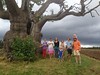
The Mollestad oak is a spirit tree, "vettetre" or "vette eik" is another therm for this tree. Several legends of unatural growth and underground beeings or mytological creatures are told about this tree. It was a common belief that ancestral spirits still were living inside the tree and lived on as a guardian spirit inside the trees. These trees occur in several places in Norway and in Scandinavia and the trees were called "vettetre". In the past the farmers put out food, milk and beer to the tree as sacrifice to these spirits. Not doing this would be bad luck for the farm and this custom have been continued up until this day, the first beer that was tapped had to be sacrificed to the tree and if it was ever damaged it would be a disaster for the farm.
The tree has been marked with information posters and a small parking lot.
You may be viewing yesterday's version of this page. To see the most up to date information please register for a free account.
")
")
")
")
Do not use the above information on other web sites or publications without permission of the contributor.
Nearby Images from Flickr


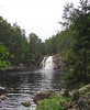

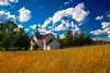
The above images may not be of the site on this page, but were taken nearby. They are loaded from Flickr so please click on them for image credits.
Click here to see more info for this site
Nearby sites
Click here to view sites on an interactive map of the areaKey: Red: member's photo, Blue: 3rd party photo, Yellow: other image, Green: no photo - please go there and take one, Grey: site destroyed
Download sites to:
KML (Google Earth)
GPX (GPS waypoints)
CSV (Garmin/Navman)
CSV (Excel)
To unlock full downloads you need to sign up as a Contributory Member. Otherwise downloads are limited to 50 sites.
Turn off the page maps and other distractions
Nearby sites listing. In the following links * = Image available
3.5km ESE 118° Skillsteinene* Stone Row / Alignment
15.4km SSW 204° Hamresanden Tingringen* Stone Circle
15.8km SSW 205° Hamresanden Ancient Village or Settlement
20.4km SSW 212° Pjolterhaugen* Round Barrow(s)
20.6km SSW 210° Oddernes Runestone* Carving
22.9km E 80° Dømmesmoen* Barrow Cemetery
23.8km E 84° Bringsvær Hellekistegraver* Cist
24.3km ENE 78° Fjære* Barrow Cemetery
25.8km ENE 76° Bringsvær* Barrow Cemetery
25.8km ENE 78° Vik (Grimstad)* Stone Circle
26.3km ENE 78° Fevikveien stone circle* Stone Circle
26.3km WSW 251° Stallemo* Barrow Cemetery
27.9km E 81° Ytre Grevstad* Stone Circle
29.2km ENE 76° Øvre Fevik* Barrow Cemetery
29.5km ENE 76° Fevikmoen* Barrow Cemetery
31.3km ENE 77° Kvennbekkrøysa* Cairn
31.4km SW 222° Tingsteinen* Ring Cairn
32.7km SW 219° Tangvall cist* Cist
32.7km SW 219° Søgne Runestone* Carving
33.6km NE 50° Mjølhusmoen* Barrow Cemetery
37.4km NW 321° Galteland Runestone and Verksmoen Barrow Cemetery* Carving
39.1km W 277° Trygsland* Carving
39.3km W 280° Bjelland* Barrow Cemetery
39.4km ENE 71° Hoveodden Røyser* Cairn
40.0km ENE 71° Hovestien* Cairn
View more nearby sites and additional images


 We would like to know more about this location. Please feel free to add a brief description and any relevant information in your own language.
 Wir möchten mehr über diese Stätte erfahren. Bitte zögern Sie nicht, eine kurze Beschreibung und relevante Informationen in Deutsch hinzuzufügen.
 Nous aimerions en savoir encore un peu sur les lieux. S'il vous plaît n'hesitez pas à ajouter une courte description et tous les renseignements pertinents dans votre propre langue.
 Quisieramos informarnos un poco más de las lugares. No dude en añadir una breve descripción y otros datos relevantes en su propio idioma.