


<< Our Photo Pages >> Tashkurgan - Ancient Village or Settlement in China
Submitted by durhamnature on Monday, 04 February 2013 Page Views: 3654
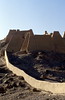
Multi-periodSite Name: Tashkurgan Alternative Name: TashkurghanCountry: China
NOTE: This site is 137.556 km away from the location you searched for.
Type: Ancient Village or Settlement
Nearest Town: Tashkurgan
Latitude: 37.772777N Longitude: 75.224444E
Condition:
| 5 | Perfect |
| 4 | Almost Perfect |
| 3 | Reasonable but with some damage |
| 2 | Ruined but still recognisable as an ancient site |
| 1 | Pretty much destroyed, possibly visible as crop marks |
| 0 | No data. |
| -1 | Completely destroyed |
| 5 | Superb |
| 4 | Good |
| 3 | Ordinary |
| 2 | Not Good |
| 1 | Awful |
| 0 | No data. |
| 5 | Can be driven to, probably with disabled access |
| 4 | Short walk on a footpath |
| 3 | Requiring a bit more of a walk |
| 2 | A long walk |
| 1 | In the middle of nowhere, a nightmare to find |
| 0 | No data. |
| 5 | co-ordinates taken by GPS or official recorded co-ordinates |
| 4 | co-ordinates scaled from a detailed map |
| 3 | co-ordinates scaled from a bad map |
| 2 | co-ordinates of the nearest village |
| 1 | co-ordinates of the nearest town |
| 0 | no data |
Internal Links:
External Links:
I have visited· I would like to visit
DrewParsons has visited here
")
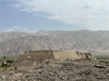
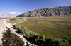
Ancient Silk Road town, 2000 years ago it was the capital of the Puli Kingdom. It is now the principal town of the Tashkurgan Tajik Autonomous County in Xinjiang.
Tashkurgan means "Stone Tower".
There is a small museum at the site of the old town.
You may be viewing yesterday's version of this page. To see the most up to date information please register for a free account.
")
")
")
Do not use the above information on other web sites or publications without permission of the contributor.
Nearby Images from Flickr

The above images may not be of the site on this page, but were taken nearby. They are loaded from Flickr so please click on them for image credits.
Click here to see more info for this site
Nearby sites
Click here to view sites on an interactive map of the areaKey: Red: member's photo, Blue: 3rd party photo, Yellow: other image, Green: no photo - please go there and take one, Grey: site destroyed
Download sites to:
KML (Google Earth)
GPX (GPS waypoints)
CSV (Garmin/Navman)
CSV (Excel)
To unlock full downloads you need to sign up as a Contributory Member. Otherwise downloads are limited to 50 sites.
Turn off the page maps and other distractions
Nearby sites listing. In the following links * = Image available
8.6km NNW 347° Jirzankal cemetery* Barrow Cemetery
169.8km SSW 198° Hunza Valley Petroglyphs* Rock Art
223.9km NNE 23° Mor Stupas* Ancient Temple
224.1km SSW 203° Kargah Buddha* Rock Art
374.3km SW 236° Chitral Graves Ancient Village or Settlement
384.1km NW 323° The Heavenly Horses Rock Art
391.1km SSE 164° Mulbekh Maitreya rock sculpture Sculptured Stone
392.3km SSE 148° Panamik Petroglyphs* Rock Art
397.6km NNW 343° Saimaly-Tash Rock Art
399.6km SSE 159° Dhomkar Rock Art* Rock Art
402.0km S 185° Burzahom Archaeological Site Standing Stones
407.2km SSE 150° Hundar Buddha sculptured stone* Rock Art
408.5km SSE 159° Khalsi Petroglyphs Rock Art
415.3km SSE 149° Diskit petroglyphs* Rock Art
416.3km SSE 157° Nurla Petroglyphs Rock Art
418.0km SSE 151° Camouflage Shield Stone* Rock Art
418.9km SSE 156° Hemis Shukpachan cup marked stone* Rock Art
418.9km SSE 156° Hemis Shukpachen Palace* Ancient Palace
418.9km SSE 156° Hemis Shukpachan engraved stone* Rock Art
418.9km SSE 156° Hemis Shukpachan Menhir* Standing Stone (Menhir)
429.3km SSE 156° Alchi petroglyphs* Rock Art
429.6km E 99° Dandan Oilik* Ancient Village or Settlement
431.9km SSE 155° Alchi Gompa* Ancient Temple
432.5km SSE 149° Kardung petroglyphs* Rock Art
432.5km SW 219° Ghalegay Caves Cave or Rock Shelter
View more nearby sites and additional images


 We would like to know more about this location. Please feel free to add a brief description and any relevant information in your own language.
 Wir möchten mehr über diese Stätte erfahren. Bitte zögern Sie nicht, eine kurze Beschreibung und relevante Informationen in Deutsch hinzuzufügen.
 Nous aimerions en savoir encore un peu sur les lieux. S'il vous plaît n'hesitez pas à ajouter une courte description et tous les renseignements pertinents dans votre propre langue.
 Quisieramos informarnos un poco más de las lugares. No dude en añadir una breve descripción y otros datos relevantes en su propio idioma.