


<< Our Photo Pages >> Girnar -Jungadh - Ancient Temple in India
Submitted by motist on Wednesday, 18 May 2011 Page Views: 7440
Multi-periodSite Name: Girnar -Jungadh Alternative Name: Kalu GiriCountry: India
NOTE: This site is 73.836 km away from the location you searched for.
Type: Ancient Temple
Nearest Town: Jungadh
Latitude: 21.526960N Longitude: 70.523023E
Condition:
| 5 | Perfect |
| 4 | Almost Perfect |
| 3 | Reasonable but with some damage |
| 2 | Ruined but still recognisable as an ancient site |
| 1 | Pretty much destroyed, possibly visible as crop marks |
| 0 | No data. |
| -1 | Completely destroyed |
| 5 | Superb |
| 4 | Good |
| 3 | Ordinary |
| 2 | Not Good |
| 1 | Awful |
| 0 | No data. |
| 5 | Can be driven to, probably with disabled access |
| 4 | Short walk on a footpath |
| 3 | Requiring a bit more of a walk |
| 2 | A long walk |
| 1 | In the middle of nowhere, a nightmare to find |
| 0 | No data. |
| 5 | co-ordinates taken by GPS or official recorded co-ordinates |
| 4 | co-ordinates scaled from a detailed map |
| 3 | co-ordinates scaled from a bad map |
| 2 | co-ordinates of the nearest village |
| 1 | co-ordinates of the nearest town |
| 0 | no data |
Internal Links:
External Links:
I have visited· I would like to visit
Andy B has visited here
")
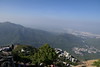
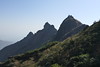
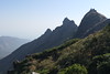
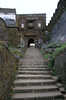
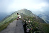
Girnar is also a sacred place for Jains and the Hindus. Girnar Temples is known to be the “anthology of mountains” which contains about five mountains. The tallest among the mountains is 945 meters high. The first mountain contains Shwetamber and Digambar temples (Jain temples), these temples stand as a fine example in terms of architecture which portray the carvings on the temple structures.
There are almost 8,000 steps located from the starting point of the first peak to the very last shrine. Girnar is a sacred place for Jains and Hindus, which attracts a large number of pilgrims. The pilgrims climb all 8,000 steps barefoot as a belief that a person who climbs all the steps barefoot reaches Heaven.
Note: Stupa from Mauryan era found in Gir sanctuary
You may be viewing yesterday's version of this page. To see the most up to date information please register for a free account.
")
")
Do not use the above information on other web sites or publications without permission of the contributor.
Nearby Images from Flickr

The above images may not be of the site on this page, but were taken nearby. They are loaded from Flickr so please click on them for image credits.
Click here to see more info for this site
Nearby sites
Click here to view sites on an interactive map of the areaKey: Red: member's photo, Blue: 3rd party photo, Yellow: other image, Green: no photo - please go there and take one, Grey: site destroyed
Download sites to:
KML (Google Earth)
GPX (GPS waypoints)
CSV (Garmin/Navman)
CSV (Excel)
To unlock full downloads you need to sign up as a Contributory Member. Otherwise downloads are limited to 50 sites.
Turn off the page maps and other distractions
Nearby sites listing. In the following links * = Image available
72.2km S 190° Somnath Jyotirlinga temple* Ancient Temple
178.9km WNW 297° Dwarka.* Ancient Temple
180.2km WNW 297° Gomtidwarka Temple* Ancient Temple
188.0km NW 320° Mandvi surroundings* Ancient Village or Settlement
188.3km NNE 29° Little Rann of Kutch* Standing Stones
188.9km NNE 30° Dhrangadhra* Standing Stone (Menhir)
190.9km N 5° Shikarpur Ancient Village or Settlement
195.6km NW 320° Ghandigram ancient cemetery* Standing Stones
196.5km NNW 336° Reha, Kutch Ramayana reliefs* Ancient Palace
198.0km N 360° Samakhiali* Standing Stones
209.5km ENE 58° Lothal* Ancient Village or Settlement
211.5km NNW 335° Bhuj* Ancient Temple
213.1km N 9° Kanmer* Ancient Village or Settlement
214.2km NNE 15° Mehardak Bet Alignment* Stone Row / Alignment
214.2km NNE 15° Mehardak Bet Temple* Ancient Temple
217.8km N 358° Kanthkot Fort, Kutch, Gujarat* Hillfort
220.8km NNW 340° Khotay, Kutch* Sculptured Stone
221.8km NNW 339° Khotay sun temple* Ancient Temple
225.2km NNW 329° Punvareshvar Temple* Ancient Temple
225.2km NNW 329° Punvareshvar Palace* Ancient Palace
227.4km N 6° Khubdi mata temple* Ancient Temple
230.4km NNE 12° Surya Narayan temple -Adesar* Ancient Temple
231.3km NNE 12° Warnu Dada Temple* Ancient Temple
234.5km NW 323° Mothala open air sanctuary* Ancient Temple
235.0km NW 323° Vinzan Vidyavhasini Devi* Ancient Temple
View more nearby sites and additional images


 We would like to know more about this location. Please feel free to add a brief description and any relevant information in your own language.
 Wir möchten mehr über diese Stätte erfahren. Bitte zögern Sie nicht, eine kurze Beschreibung und relevante Informationen in Deutsch hinzuzufügen.
 Nous aimerions en savoir encore un peu sur les lieux. S'il vous plaît n'hesitez pas à ajouter une courte description et tous les renseignements pertinents dans votre propre langue.
 Quisieramos informarnos un poco más de las lugares. No dude en añadir una breve descripción y otros datos relevantes en su propio idioma.