


<< Our Photo Pages >> Bibelistein - Standing Stone (Menhir) in Germany in Baden-Wuerttemberg
Submitted by AlexHunger on Tuesday, 13 September 2005 Page Views: 4269
Neolithic and Bronze AgeSite Name: Bibelistein Alternative Name: Glückelestein, PipelisteinCountry: Germany
NOTE: This site is 4.279 km away from the location you searched for.
Land: Baden-Wuerttemberg Type: Standing Stone (Menhir)
Nearest Town: Strasbourg Nearest Village: Ortenberg
Latitude: 48.444630N Longitude: 7.975200E
Condition:
| 5 | Perfect |
| 4 | Almost Perfect |
| 3 | Reasonable but with some damage |
| 2 | Ruined but still recognisable as an ancient site |
| 1 | Pretty much destroyed, possibly visible as crop marks |
| 0 | No data. |
| -1 | Completely destroyed |
| 5 | Superb |
| 4 | Good |
| 3 | Ordinary |
| 2 | Not Good |
| 1 | Awful |
| 0 | No data. |
| 5 | Can be driven to, probably with disabled access |
| 4 | Short walk on a footpath |
| 3 | Requiring a bit more of a walk |
| 2 | A long walk |
| 1 | In the middle of nowhere, a nightmare to find |
| 0 | No data. |
| 5 | co-ordinates taken by GPS or official recorded co-ordinates |
| 4 | co-ordinates scaled from a detailed map |
| 3 | co-ordinates scaled from a bad map |
| 2 | co-ordinates of the nearest village |
| 1 | co-ordinates of the nearest town |
| 0 | no data |
Internal Links:
External Links:
")
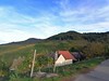
1.5 metre tall menhir in vineyards close to castle. Partially overgrown.
You may be viewing yesterday's version of this page. To see the most up to date information please register for a free account.
Do not use the above information on other web sites or publications without permission of the contributor.
Nearby Images from Flickr

The above images may not be of the site on this page, but were taken nearby. They are loaded from Flickr so please click on them for image credits.
Click here to see more info for this site
Nearby sites
Click here to view sites on an interactive map of the areaKey: Red: member's photo, Blue: 3rd party photo, Yellow: other image, Green: no photo - please go there and take one, Grey: site destroyed
Download sites to:
KML (Google Earth)
GPX (GPS waypoints)
CSV (Garmin/Navman)
CSV (Excel)
To unlock full downloads you need to sign up as a Contributory Member. Otherwise downloads are limited to 50 sites.
Turn off the page maps and other distractions
Nearby sites listing. In the following links * = Image available
4.9km NNW 345° Brücklesbünd Menhir* Standing Stone (Menhir)
5.7km N 4° Der Dicke Stein Bohlsbach Standing Stone (Menhir)
7.9km SE 139° Heidenplatz und Steinsofa Schwaibach* Rock Art
13.7km ESE 123° Summstein Oberharmersbach Modern Stone Circle etc
13.8km SE 144° Summstein am Egelwaldweg Modern Stone Circle etc
17.6km WNW 303° Dolmen du Stockfeld Chambered Tomb
22.3km SW 220° Keltisches Fürstengrab von Kappel* Round Barrow(s)
22.4km NW 313° Palais de Rohan Musee Archeologique Museum
33.8km N 3° Greffern Menhir II Standing Stone (Menhir)
33.8km N 3° Greffern Menhir I Standing Stone (Menhir)
35.3km WNW 286° Langenstein de Dorlisheim* Standing Stone (Menhir)
36.9km SSW 207° Mithraeum Riegel* Ancient Temple
36.9km SSE 153° Summstein Schonach* Modern Stone Circle etc
37.5km SSE 154° Schalensteinpfad Schonach* Sculptured Stone
37.9km SE 146° Schalensteine Gremmelsbach* Rock Art
38.5km E 81° Summstein Hallwangen I Modern Stone Circle etc
39.0km NE 45° Giersteine Natural Stone / Erratic / Other Natural Feature
39.8km NNE 13° Heiligenbuck Artificial Mound
40.6km SE 133° Tennenbronn Hinkelstein* Standing Stone (Menhir)
41.5km WSW 250° Pierre de la Chapelle Saint-Jean* Standing Stone (Menhir)
41.8km WSW 237° Mussig Tumuli* Artificial Mound
41.8km WSW 237° Nachtweide Tumuli* Artificial Mound
41.9km SW 214° Gräberfeld Königschaffhausen* Barrow Cemetery
42.1km W 269° Mont St. Odile* Hillfort
42.1km W 269° Fountain Sainte-Odile* Holy Well or Sacred Spring
View more nearby sites and additional images


 We would like to know more about this location. Please feel free to add a brief description and any relevant information in your own language.
 Wir möchten mehr über diese Stätte erfahren. Bitte zögern Sie nicht, eine kurze Beschreibung und relevante Informationen in Deutsch hinzuzufügen.
 Nous aimerions en savoir encore un peu sur les lieux. S'il vous plaît n'hesitez pas à ajouter une courte description et tous les renseignements pertinents dans votre propre langue.
 Quisieramos informarnos un poco más de las lugares. No dude en añadir una breve descripción y otros datos relevantes en su propio idioma.