


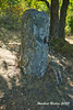
<< Other Photo Pages >> Dreiherrenstein am Kamp - Marker Stone in Germany in North Rhine-Westphalia
Submitted by Harald_Platta on Sunday, 09 June 2019 Page Views: 673
Multi-periodSite Name: Dreiherrenstein am KampCountry: Germany
NOTE: This site is 7.214 km away from the location you searched for.
Land: North Rhine-Westphalia Type: Marker Stone
Nearest Town: Reichshof Nearest Village: Wildberg
Latitude: 50.939980N Longitude: 7.785980E
Condition:
| 5 | Perfect |
| 4 | Almost Perfect |
| 3 | Reasonable but with some damage |
| 2 | Ruined but still recognisable as an ancient site |
| 1 | Pretty much destroyed, possibly visible as crop marks |
| 0 | No data. |
| -1 | Completely destroyed |
| 5 | Superb |
| 4 | Good |
| 3 | Ordinary |
| 2 | Not Good |
| 1 | Awful |
| 0 | No data. |
| 5 | Can be driven to, probably with disabled access |
| 4 | Short walk on a footpath |
| 3 | Requiring a bit more of a walk |
| 2 | A long walk |
| 1 | In the middle of nowhere, a nightmare to find |
| 0 | No data. |
| 5 | co-ordinates taken by GPS or official recorded co-ordinates |
| 4 | co-ordinates scaled from a detailed map |
| 3 | co-ordinates scaled from a bad map |
| 2 | co-ordinates of the nearest village |
| 1 | co-ordinates of the nearest town |
| 0 | no data |
Internal Links:
External Links:
")
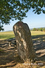
The stone is unusually large for a marker stone of this area. It has a height of 1.60 m above the ground and reaches at least 1 m into the ground. Its diameter is 0.70 m. It has been speculated that it original might have been a menhir.
Reference:
[01] „Dreiherrenstein am Hofe Kamp zu Wildberg”. In: KuLaDig, Kultur.Landschaft.Digital. URL: https://www.kuladig.de/Objektansicht/O-70755-20130731-2
You may be viewing yesterday's version of this page. To see the most up to date information please register for a free account.
Do not use the above information on other web sites or publications without permission of the contributor.
Nearby Images from Flickr
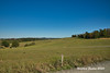
The above images may not be of the site on this page, but were taken nearby. They are loaded from Flickr so please click on them for image credits.
Click here to see more info for this site
Nearby sites
Click here to view sites on an interactive map of the areaKey: Red: member's photo, Blue: 3rd party photo, Yellow: other image, Green: no photo - please go there and take one, Grey: site destroyed
Download sites to:
KML (Google Earth)
GPX (GPS waypoints)
CSV (Garmin/Navman)
CSV (Excel)
To unlock full downloads you need to sign up as a Contributory Member. Otherwise downloads are limited to 50 sites.
Turn off the page maps and other distractions
Nearby sites listing. In the following links * = Image available
11.6km NW 320° Heiliger Brunnen Wiedenest* Holy Well or Sacred Spring
15.2km ESE 124° Siegen La Tène Ironworks Ancient Mine, Quarry or other Industry
17.2km SSW 209° Heilger Brunnen Halscheid Holy Well or Sacred Spring
17.4km W 260° Summstein Nümbrecht Modern Stone Circle etc
18.3km SSE 152° Druidenstein Kirchen* Natural Stone / Erratic / Other Natural Feature
18.6km ESE 113° Siegerlandmuseum* Museum
18.9km SSE 158° Abschnittsbefestigung Alsdorf* Promontory Fort / Cliff Castle
20.8km NE 39° Wallburg Hofkühl* Hillfort
20.9km NE 36° Wallburg Jäckelchen* Hillfort
23.9km S 188° Altburg Stein-Wingert* Hillfort
24.1km SW 224° Heilbrunnen am Ohmbach* Holy Well or Sacred Spring
24.2km SE 136° Zeppenfeld Iron Age Forge Ancient Mine, Quarry or other Industry
24.5km SE 145° Wallburg Hohenseelenbachskopf Hillfort
25.8km E 91° Alte Burg Obernau* Hillfort
27.3km WNW 298° Zwergenhöhle Lindlar* Cave or Rock Shelter
27.4km NNE 32° Wallburg Borghausen Hillfort
28.6km NE 45° Wallburg Kahle* Hillfort
29.0km ESE 115° Höllenrain Iron Age Forge Ancient Mine, Quarry or other Industry
29.2km NE 39° Wallburg Weilenscheid* Hillfort
29.9km SE 139° Burg von Burbach* Hillfort
31.0km S 174° Steinkistengrab Oberzeuzheim* Chambered Tomb
31.6km WNW 285° Summstein Lindlar Modern Stone Circle etc
32.1km WSW 247° Teufelskiste* Natural Stone / Erratic / Other Natural Feature
32.4km E 94° Siegquelle* Holy Well or Sacred Spring
33.9km ENE 56° Heiligenborn Saalhausen Holy Well or Sacred Spring
View more nearby sites and additional images


 We would like to know more about this location. Please feel free to add a brief description and any relevant information in your own language.
 Wir möchten mehr über diese Stätte erfahren. Bitte zögern Sie nicht, eine kurze Beschreibung und relevante Informationen in Deutsch hinzuzufügen.
 Nous aimerions en savoir encore un peu sur les lieux. S'il vous plaît n'hesitez pas à ajouter une courte description et tous les renseignements pertinents dans votre propre langue.
 Quisieramos informarnos un poco más de las lugares. No dude en añadir una breve descripción y otros datos relevantes en su propio idioma.