 with our Megalithic Portal iPhone app")


<< Our Photo Pages >> Linvågen - Standing Stone (Menhir) in Norway in Møre og Romsdal
Submitted by kenntha88 on Friday, 29 October 2021 Page Views: 305
Iron Age and Later PrehistorySite Name: LinvågenCountry: Norway
NOTE: This site is 15.287 km away from the location you searched for.
Fylke: Møre og Romsdal Type: Standing Stone (Menhir)
Nearest Town: Kristiansund
Latitude: 63.178614N Longitude: 7.947809E
Condition:
| 5 | Perfect |
| 4 | Almost Perfect |
| 3 | Reasonable but with some damage |
| 2 | Ruined but still recognisable as an ancient site |
| 1 | Pretty much destroyed, possibly visible as crop marks |
| 0 | No data. |
| -1 | Completely destroyed |
| 5 | Superb |
| 4 | Good |
| 3 | Ordinary |
| 2 | Not Good |
| 1 | Awful |
| 0 | No data. |
| 5 | Can be driven to, probably with disabled access |
| 4 | Short walk on a footpath |
| 3 | Requiring a bit more of a walk |
| 2 | A long walk |
| 1 | In the middle of nowhere, a nightmare to find |
| 0 | No data. |
| 5 | co-ordinates taken by GPS or official recorded co-ordinates |
| 4 | co-ordinates scaled from a detailed map |
| 3 | co-ordinates scaled from a bad map |
| 2 | co-ordinates of the nearest village |
| 1 | co-ordinates of the nearest town |
| 0 | no data |
Internal Links:
External Links:
")
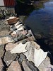
At the island of Tustna just next to the main road is a standing stone. It is located on a rocky outcrop overlooking the road around 2 metres up from the road. The stone may have been having a different original location but was moved when the road was contructed but it was not possible to have this confirmed.
The stone has the shape of a narrow stone slab. The stone is 2,10 metres in height, 45cm wide on its widest and 20cm thick with an almost rectangular cross section. It is of a light grey stone and have some moss growth. The top ends in a small point.
You may be viewing yesterday's version of this page. To see the most up to date information please register for a free account.
")
")
")
Do not use the above information on other web sites or publications without permission of the contributor.
Nearby Images from Flickr


The above images may not be of the site on this page, but were taken nearby. They are loaded from Flickr so please click on them for image credits.
Click here to see more info for this site
Nearby sites
Click here to view sites on an interactive map of the areaKey: Red: member's photo, Blue: 3rd party photo, Yellow: other image, Green: no photo - please go there and take one, Grey: site destroyed
Download sites to:
KML (Google Earth)
GPX (GPS waypoints)
CSV (Garmin/Navman)
CSV (Excel)
To unlock full downloads you need to sign up as a Contributory Member. Otherwise downloads are limited to 50 sites.
Turn off the page maps and other distractions
Nearby sites listing. In the following links * = Image available
11.2km E 95° Malivika standing stone* Standing Stone (Menhir)
15.0km NNE 26° Kulisteinen* Early Christian Sculptured Stone
15.6km NNE 30° Edøyveien Gravfelt* Barrow Cemetery
16.0km NNE 30° Tittinghaugen-Sør Kuløya* Barrow Cemetery
16.1km NNE 30° Nord-Kuløya barrow cemetery* Barrow Cemetery
16.2km NNE 30° Kuli Phallic Stone* Standing Stone (Menhir)
18.4km S 187° Aspa Standing Stones* Standing Stones
18.7km SSW 203° Frei Standing Stones* Standing Stones
22.3km SSW 211° Kvernes Tingsted* Stone Circle
25.2km SSW 204° Ikornneset* Barrow Cemetery
25.3km SW 232° Søfstadklubben* Rock Art
30.7km ENE 71° Aure Kirke Standing Stone* Standing Stone (Menhir)
35.1km SW 220° Håkonrøysa* Cairn
37.3km SSE 163° Honnhammarneset* Rock Art
37.5km SSE 148° Røttingsnes* Barrow Cemetery
37.6km WSW 240° Rullesteinshaugen* Cairn
44.5km WSW 242° Sandvikshagen* Barrow Cemetery
49.4km S 172° Boggestranda* Carving
49.8km WSW 242° Malefeten* Barrow Cemetery
55.9km SSW 203° Horga Pagan Altar* Sculptured Stone
58.7km SSW 212° Jutahaugen* Stone Circle
58.8km WSW 239° Gule* Standing Stone (Menhir)
58.8km SSW 212° The Troll's Arrow* Standing Stone (Menhir)
61.4km SSW 208° Nesje Standing Stones* Standing Stones
61.6km SW 230° Reithaugen Round Barrow(s)
View more nearby sites and additional images


 We would like to know more about this location. Please feel free to add a brief description and any relevant information in your own language.
 Wir möchten mehr über diese Stätte erfahren. Bitte zögern Sie nicht, eine kurze Beschreibung und relevante Informationen in Deutsch hinzuzufügen.
 Nous aimerions en savoir encore un peu sur les lieux. S'il vous plaît n'hesitez pas à ajouter une courte description et tous les renseignements pertinents dans votre propre langue.
 Quisieramos informarnos un poco más de las lugares. No dude en añadir una breve descripción y otros datos relevantes en su propio idioma.