


<< Our Photo Pages >> Freistuhl an der Femlinde - Natural Stone / Erratic / Other Natural Feature in Germany in North Rhine-Westphalia
Submitted by Harald_Platta on Wednesday, 20 January 2016 Page Views: 1852
Natural PlacesSite Name: Freistuhl an der Femlinde Alternative Name: Vehmlinde, Dortmunder FreistuhlCountry: Germany
NOTE: This site is 0.566 km away from the location you searched for.
Land: North Rhine-Westphalia Type: Natural Stone / Erratic / Other Natural Feature
Nearest Town: Dortmund
Latitude: 51.516718N Longitude: 7.461323E
Condition:
| 5 | Perfect |
| 4 | Almost Perfect |
| 3 | Reasonable but with some damage |
| 2 | Ruined but still recognisable as an ancient site |
| 1 | Pretty much destroyed, possibly visible as crop marks |
| 0 | No data. |
| -1 | Completely destroyed |
| 5 | Superb |
| 4 | Good |
| 3 | Ordinary |
| 2 | Not Good |
| 1 | Awful |
| 0 | No data. |
| 5 | Can be driven to, probably with disabled access |
| 4 | Short walk on a footpath |
| 3 | Requiring a bit more of a walk |
| 2 | A long walk |
| 1 | In the middle of nowhere, a nightmare to find |
| 0 | No data. |
| 5 | co-ordinates taken by GPS or official recorded co-ordinates |
| 4 | co-ordinates scaled from a detailed map |
| 3 | co-ordinates scaled from a bad map |
| 2 | co-ordinates of the nearest village |
| 1 | co-ordinates of the nearest town |
| 0 | no data |
Internal Links:
External Links:
")
The age of the site is unknown. It could have possibly already have been used as Germanic thing site, as discussed for the still existing Femeiche in Raesfeld or the destroyed Femlinde in Bochum.
The original localisation was near the Westenpforte gate outside of the city wall. When this part of the wall was deconstructed, the court site was moved to the Burgpforte gate in 1545.
The vehmic court was active until 1803. When the railway station was planned, the Femlinde was excavated and implanted at a new site (40 m to the South) in 1910. Unfortunately, the tree did not survive this procedure.
Two young lime trees were planted at this new site. The lime trees and the original stone table and stone seats were destroyed by bombing in 1944.
A memorial was built to commemorate the site. It consists of six boulders that symbolise the seats of the judge and the jury as well as a stone table with the engraved information about the site. This memorial site does not look like the original stone setting. After it was moved again in 1953, it finally was placed at is current localization in 1973 (see coordinates at the top of the page).
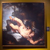
A small oil painting by Carl Heinrich Beichling from 1872 can be seen in the
Museum für Kunst- und Kulturgeschichte Dortmund.
It is interesting to note, that several scions had been taken from the original trees before they were excavated. These scions were sent to Barmen (now a part of Wuppertal), Witten, Bremen, Detmold, Leipzig and New York.
Literature:
[01] Loge zur Alten Linde (Hrsg.): Vom Lindenbaum am Königshof (Webpage).
[02] Meyer-Kahrweg, R.: Denkmäler, Brunnen und Plastiken in Wuppertal (1991).
[03] Strothmann, K.-H. (Hrsg.): Dortmunder Stadtgeschichte im Spiegel alter Ansichtskarten (1977).
[04] Höfken, G.: Beiträge zur Geschichte des Gerichtswesens in Bochum Stadt und Land in älterer Zeit. In: Heimatbücher – 2. Heimatbuch 1927 (1927).
[05] Kaemmel, O.: Deutsche Geschichte - Erster Teil (1911).
You may be viewing yesterday's version of this page. To see the most up to date information please register for a free account.
")
")
")
")
Do not use the above information on other web sites or publications without permission of the contributor.
Nearby Images from Flickr

The above images may not be of the site on this page, but were taken nearby. They are loaded from Flickr so please click on them for image credits.
Click here to see more info for this site
Nearby sites
Click here to view sites on an interactive map of the areaKey: Red: member's photo, Blue: 3rd party photo, Yellow: other image, Green: no photo - please go there and take one, Grey: site destroyed
Download sites to:
KML (Google Earth)
GPX (GPS waypoints)
CSV (Garmin/Navman)
CSV (Excel)
To unlock full downloads you need to sign up as a Contributory Member. Otherwise downloads are limited to 50 sites.
Turn off the page maps and other distractions
Nearby sites listing. In the following links * = Image available
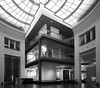
116m E 94° Museum für Kunst- und Kulturgeschichte* Museum
290m SE 132° Stein mit Vollausstattung* Modern Stone Circle etc
1.7km ESE 104° Summstein am Artur Schulze-Engels Platz* Modern Stone Circle etc
2.2km ENE 62° Summstein im Hoeschpark* Modern Stone Circle etc
5.9km WSW 251° Schlüsselloch-Gräberfeld Oespeler Bach* Barrow Cemetery
5.9km WSW 248° Im Weißen Feld* Ancient Village or Settlement
6.9km SE 129° Summstein Berghofen* Modern Stone Circle etc
8.2km SE 131° Berghofen Huegelgrab* Round Barrow(s)
8.3km SE 137° Berghofer Wald Huegelgrab 1* Round Barrow(s)
8.4km SE 131° Lohbach Quelle* Holy Well or Sacred Spring
8.6km NE 41° Lanstrop Iron Age Settlement* Ancient Village or Settlement
9.0km SW 218° Grotenbach* Holy Well or Sacred Spring
9.5km SE 140° Grabhügel Drüfel Round Barrow(s)
10.5km S 170° Petersbrunnen* Holy Well or Sacred Spring
10.6km W 262° Auf dem Gericht - Rössen Settlement* Ancient Village or Settlement
10.7km S 169° Syburg Cross-Stone* Ancient Cross
10.7km S 170° Brunnen Femgerichtsstätte Oberhof* Holy Well or Sacred Spring
10.7km S 171° Wallburg Syburg* Hillfort
11.3km SE 138° Ruhrtalmuseum* Museum
11.6km SE 144° Steinsetzung Wandhofen* Modern Stone Circle etc
12.0km NW 316° Ickern Bridges Ancient Trackway
12.3km N 9° Alstedder Hünengrab* Chambered Tomb
12.5km S 184° Teufelskanzel* Rock Outcrop
12.5km W 259° Ruhr-Park Rössen Settlement Ancient Village or Settlement
12.9km W 263° Auf dem Knust Rössen Settlement* Ancient Village or Settlement
View more nearby sites and additional images


 We would like to know more about this location. Please feel free to add a brief description and any relevant information in your own language.
 Wir möchten mehr über diese Stätte erfahren. Bitte zögern Sie nicht, eine kurze Beschreibung und relevante Informationen in Deutsch hinzuzufügen.
 Nous aimerions en savoir encore un peu sur les lieux. S'il vous plaît n'hesitez pas à ajouter une courte description et tous les renseignements pertinents dans votre propre langue.
 Quisieramos informarnos un poco más de las lugares. No dude en añadir una breve descripción y otros datos relevantes en su propio idioma.