


<< Text Pages >> Brotsch Mur Paien - Ancient Village or Settlement in France in Alsace-Lorraine:Bas-Rhin (67)
Submitted by AlexHunger on Saturday, 16 April 2005 Page Views: 3603
Multi-periodSite Name: Brotsch Mur Paien Alternative Name: Tour de BrotschCountry: France
NOTE: This site is 4.943 km away from the location you searched for.
Département: Alsace-Lorraine:Bas-Rhin (67) Type: Ancient Village or Settlement
Nearest Town: Saverne Nearest Village: Reinhardsmunster
Latitude: 48.704280N Longitude: 7.323930E
Condition:
| 5 | Perfect |
| 4 | Almost Perfect |
| 3 | Reasonable but with some damage |
| 2 | Ruined but still recognisable as an ancient site |
| 1 | Pretty much destroyed, possibly visible as crop marks |
| 0 | No data. |
| -1 | Completely destroyed |
| 5 | Superb |
| 4 | Good |
| 3 | Ordinary |
| 2 | Not Good |
| 1 | Awful |
| 0 | No data. |
| 5 | Can be driven to, probably with disabled access |
| 4 | Short walk on a footpath |
| 3 | Requiring a bit more of a walk |
| 2 | A long walk |
| 1 | In the middle of nowhere, a nightmare to find |
| 0 | No data. |
| 5 | co-ordinates taken by GPS or official recorded co-ordinates |
| 4 | co-ordinates scaled from a detailed map |
| 3 | co-ordinates scaled from a bad map |
| 2 | co-ordinates of the nearest village |
| 1 | co-ordinates of the nearest town |
| 0 | no data |
Internal Links:
External Links:
Ancient Settlement in Bas Rhin
2 Km North West of Town. Stone wall, Ancient Settlement . There is a 19th Century tower/lookout point and Hexentisch cave nearby.
IMPORTANT NOTE: Positional co-ordinates scaled from a detailed map source
You may be viewing yesterday's version of this page. To see the most up to date information please register for a free account.
Do not use the above information on other web sites or publications without permission of the contributor.
Nearby Images from Flickr

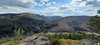
The above images may not be of the site on this page, but were taken nearby. They are loaded from Flickr so please click on them for image credits.
Click here to see more info for this site
Nearby sites
Click here to view sites on an interactive map of the areaKey: Red: member's photo, Blue: 3rd party photo, Yellow: other image, Green: no photo - please go there and take one, Grey: site destroyed
Download sites to:
KML (Google Earth)
GPX (GPS waypoints)
CSV (Garmin/Navman)
CSV (Excel)
To unlock full downloads you need to sign up as a Contributory Member. Otherwise downloads are limited to 50 sites.
Turn off the page maps and other distractions
Nearby sites listing. In the following links * = Image available
94m SSW 213° Hexentisch Cave or Rock Shelter
1.7km WSW 242° Pierre des Druides (Reinhardsmunster)* Rock Outcrop
2.1km SW 233° Krappenfels Murs Paien* Misc. Earthwork
2.3km SSW 196° Rocher du Hibou Natural Stone / Erratic / Other Natural Feature
3.7km SSW 207° Rocher de la Spill* Rock Outcrop
5.1km SSW 196° Sattelfelsen* Standing Stone (Menhir)
5.2km SSW 206° Le Table des Géants* Natural Stone / Erratic / Other Natural Feature
5.7km N 5° The jump of Prince Charles* Ancient Trackway
6.1km SW 235° Les Bornes Saint-Martin* Standing Stone (Menhir)
8.4km NNE 20° Rond des Sorcières* Ancient Temple
8.5km NNE 20° Grotte l'école des sorcières* Cave or Rock Shelter
8.6km N 4° Stampfloecher Eschbourg Rock Art
9.0km SSW 212° Le Rutschfelsen Rock Art
9.3km SSE 165° Heidenschloss* Ancient Village or Settlement
9.8km NNE 20° Heidenstadt Oppidum Ancient Village or Settlement
9.9km NNE 20° Menhir d'Heidenstadt Standing Stone (Menhir)
10.7km N 352° Roche Ecrite Not Known (by us)
12.9km SW 234° Les Trois Saintes* Rock Cut Tomb
13.7km SW 231° Rocher du Hohwalsch* Rock Outcrop
14.6km WSW 242° Grotte Saint-Léon* Cave or Rock Shelter
16.2km N 9° Neuwiller-lès-Saverne Croix Ancient Cross
16.4km S 187° Ringelsberg Fortifications Gallo-romaines Hillfort
16.6km NNE 15° Pierre de Pfannenfelsen Rock Art
16.9km WSW 241° Abreschviller Roche du Diable* Natural Stone / Erratic / Other Natural Feature
17.2km WSW 241° Menhir du Kunkel* Standing Stone (Menhir)
View more nearby sites and additional images


 We would like to know more about this location. Please feel free to add a brief description and any relevant information in your own language.
 Wir möchten mehr über diese Stätte erfahren. Bitte zögern Sie nicht, eine kurze Beschreibung und relevante Informationen in Deutsch hinzuzufügen.
 Nous aimerions en savoir encore un peu sur les lieux. S'il vous plaît n'hesitez pas à ajouter une courte description et tous les renseignements pertinents dans votre propre langue.
 Quisieramos informarnos un poco más de las lugares. No dude en añadir una breve descripción y otros datos relevantes en su propio idioma.