
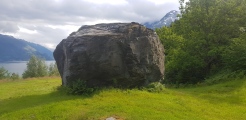

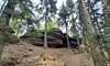
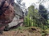
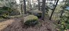
<< Other Photo Pages >> Pierre des Druides (Reinhardsmunster) - Rock Outcrop in France in Alsace-Lorraine:Bas-Rhin (67)
Submitted by holger_rix on Wednesday, 06 April 2016 Page Views: 1790
Natural PlacesSite Name: Pierre des Druides (Reinhardsmunster)Country: France
NOTE: This site is 3.977 km away from the location you searched for.
Département: Alsace-Lorraine:Bas-Rhin (67) Type: Rock Outcrop
Nearest Town: Saverne Nearest Village: Reinhardsmunster
Latitude: 48.697100N Longitude: 7.303640E
Condition:
| 5 | Perfect |
| 4 | Almost Perfect |
| 3 | Reasonable but with some damage |
| 2 | Ruined but still recognisable as an ancient site |
| 1 | Pretty much destroyed, possibly visible as crop marks |
| 0 | No data. |
| -1 | Completely destroyed |
| 5 | Superb |
| 4 | Good |
| 3 | Ordinary |
| 2 | Not Good |
| 1 | Awful |
| 0 | No data. |
| 5 | Can be driven to, probably with disabled access |
| 4 | Short walk on a footpath |
| 3 | Requiring a bit more of a walk |
| 2 | A long walk |
| 1 | In the middle of nowhere, a nightmare to find |
| 0 | No data. |
| 5 | co-ordinates taken by GPS or official recorded co-ordinates |
| 4 | co-ordinates scaled from a detailed map |
| 3 | co-ordinates scaled from a bad map |
| 2 | co-ordinates of the nearest village |
| 1 | co-ordinates of the nearest town |
| 0 | no data |
Be the first person to rate this site - see the 'Contribute!' box in the right hand menu.
Internal Links:
External Links:
 (PID:148017)")
Chemin Forestier du Hirschberg, Reinhardsmunster, Saverne, Bas-Rhin, Alsace-Champagne-Ardenne-Lorraine
Source: T4T35.fr
Picture:
www.panoramio.com
Information: La Montagne de Wotan
www.lieux-insolites.fr
You may be viewing yesterday's version of this page. To see the most up to date information please register for a free account.
Do not use the above information on other web sites or publications without permission of the contributor.
Nearby Images from Flickr
The above images may not be of the site on this page, but were taken nearby. They are loaded from Flickr so please click on them for image credits.
Click here to see more info for this site
Nearby sites
Click here to view sites on an interactive map of the areaKey: Red: member's photo, Blue: 3rd party photo, Yellow: other image, Green: no photo - please go there and take one, Grey: site destroyed
Download sites to:
KML (Google Earth)
GPX (GPS waypoints)
CSV (Garmin/Navman)
CSV (Excel)
To unlock full downloads you need to sign up as a Contributory Member. Otherwise downloads are limited to 50 sites.
Turn off the page maps and other distractions
Nearby sites listing. In the following links * = Image available
488m SSW 199° Krappenfels Murs Paien* Misc. Earthwork
1.6km ENE 63° Hexentisch Cave or Rock Shelter
1.7km SSE 150° Rocher du Hibou Natural Stone / Erratic / Other Natural Feature
1.7km ENE 62° Brotsch Mur Paien Ancient Village or Settlement
2.5km S 185° Rocher de la Spill* Rock Outcrop
4.0km SSW 192° Le Table des Géants* Natural Stone / Erratic / Other Natural Feature
4.1km S 179° Sattelfelsen* Standing Stone (Menhir)
4.4km SW 232° Les Bornes Saint-Martin* Standing Stone (Menhir)
6.8km NNE 17° The jump of Prince Charles* Ancient Trackway
7.6km SSW 206° Le Rutschfelsen Rock Art
9.1km SSE 155° Heidenschloss* Ancient Village or Settlement
9.6km NNE 12° Stampfloecher Eschbourg Rock Art
9.8km NNE 27° Rond des Sorcières* Ancient Temple
9.8km NNE 27° Grotte l'école des sorcières* Cave or Rock Shelter
11.1km NNE 26° Heidenstadt Oppidum Ancient Village or Settlement
11.2km SW 233° Les Trois Saintes* Rock Cut Tomb
11.2km NNE 26° Menhir d'Heidenstadt Standing Stone (Menhir)
11.4km N 0° Roche Ecrite Not Known (by us)
12.1km SW 229° Rocher du Hohwalsch* Rock Outcrop
13.0km WSW 242° Grotte Saint-Léon* Cave or Rock Shelter
15.2km WSW 241° Abreschviller Roche du Diable* Natural Stone / Erratic / Other Natural Feature
15.4km S 182° Ringelsberg Fortifications Gallo-romaines Hillfort
15.5km WSW 241° Menhir du Kunkel* Standing Stone (Menhir)
16.7km SSW 193° Porte de Pierre Mur Paien* Misc. Earthwork
16.7km SSW 193° Porte de Pierre Monolithe* Natural Stone / Erratic / Other Natural Feature
View more nearby sites and additional images


 We would like to know more about this location. Please feel free to add a brief description and any relevant information in your own language.
 Wir möchten mehr über diese Stätte erfahren. Bitte zögern Sie nicht, eine kurze Beschreibung und relevante Informationen in Deutsch hinzuzufügen.
 Nous aimerions en savoir encore un peu sur les lieux. S'il vous plaît n'hesitez pas à ajouter une courte description et tous les renseignements pertinents dans votre propre langue.
 Quisieramos informarnos un poco más de las lugares. No dude en añadir una breve descripción y otros datos relevantes en su propio idioma.