


<< Our Photo Pages >> Jardin des Fées Menhir II - Standing Stone (Menhir) in France in Alsace-Lorraine:Bas-Rhin (67)
Submitted by KaiHofmann on Sunday, 01 April 2018 Page Views: 885
Neolithic and Bronze AgeSite Name: Jardin des Fées Menhir IICountry: France
NOTE: This site is 3.756 km away from the location you searched for.
Département: Alsace-Lorraine:Bas-Rhin (67) Type: Standing Stone (Menhir)
Nearest Town: Molsheim Nearest Village: Lutzelhouse
Latitude: 48.533772N Longitude: 7.250869E
Condition:
| 5 | Perfect |
| 4 | Almost Perfect |
| 3 | Reasonable but with some damage |
| 2 | Ruined but still recognisable as an ancient site |
| 1 | Pretty much destroyed, possibly visible as crop marks |
| 0 | No data. |
| -1 | Completely destroyed |
| 5 | Superb |
| 4 | Good |
| 3 | Ordinary |
| 2 | Not Good |
| 1 | Awful |
| 0 | No data. |
| 5 | Can be driven to, probably with disabled access |
| 4 | Short walk on a footpath |
| 3 | Requiring a bit more of a walk |
| 2 | A long walk |
| 1 | In the middle of nowhere, a nightmare to find |
| 0 | No data. |
| 5 | co-ordinates taken by GPS or official recorded co-ordinates |
| 4 | co-ordinates scaled from a detailed map |
| 3 | co-ordinates scaled from a bad map |
| 2 | co-ordinates of the nearest village |
| 1 | co-ordinates of the nearest town |
| 0 | no data |
Internal Links:
External Links:
")
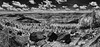
A smaller around 90 cm tall menhir on the top of the mountain at the Jardin des Fées sanctuary.
You may be viewing yesterday's version of this page. To see the most up to date information please register for a free account.
")
Do not use the above information on other web sites or publications without permission of the contributor.
Nearby Images from Flickr
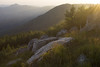

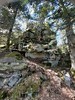

The above images may not be of the site on this page, but were taken nearby. They are loaded from Flickr so please click on them for image credits.
Click here to see more info for this site
Nearby sites
Click here to view sites on an interactive map of the areaKey: Red: member's photo, Blue: 3rd party photo, Yellow: other image, Green: no photo - please go there and take one, Grey: site destroyed
Download sites to:
KML (Google Earth)
GPX (GPS waypoints)
CSV (Garmin/Navman)
CSV (Excel)
To unlock full downloads you need to sign up as a Contributory Member. Otherwise downloads are limited to 50 sites.
Turn off the page maps and other distractions
Nearby sites listing. In the following links * = Image available
30m NE 54° Enceinte du Jardin des Fees* Rock Outcrop
59m NNW 337° Jardin des Fées Menhir I path* Standing Stone (Menhir)
770m NNE 31° Menhir du Kappelbronn* Standing Stone (Menhir)
1.9km N 6° Porte de Pierre cup mark stone* Rock Art
1.9km N 6° Porte de Pierre Monolithe* Natural Stone / Erratic / Other Natural Feature
1.9km N 7° Porte de Pierre Mur Paien* Misc. Earthwork
4.3km NE 50° Ringelsberg Fortifications Gallo-romaines Hillfort
6.6km W 275° Le Sac de Pierre* Standing Stone (Menhir)
6.8km WSW 250° Donon Temples* Ancient Temple
7.0km WSW 249° Donon Hillfort Rampart* Hillfort
7.0km WSW 249° Donon Holy Well* Holy Well or Sacred Spring
7.0km WSW 249° Donon Temple I* Ancient Temple
7.3km WSW 247° Donon Menhir* Standing Stone (Menhir)
7.3km WSW 248° Donon Roche a Basin* Rock Art
7.7km WSW 247° Donon Cup Mark Stone* Rock Art
10.0km WNW 295° Pierre Saint Quirin Rock Art
11.4km N 3° Le Rutschfelsen Rock Art
11.6km NNW 333° Rocher du Hohwalsch* Rock Outcrop
11.7km W 263° Pierres du Sabbat* Standing Stones
12.5km NNW 336° Les Trois Saintes* Rock Cut Tomb
12.6km NE 38° Heidenschloss* Ancient Village or Settlement
12.9km SW 234° Pierres à Cupules du Moussey Rock Art
13.6km NW 309° St.Quirin Necropolis* Ancient Village or Settlement
13.8km NW 308° Pierres a cupules de St. Quirin* Rock Art
14.3km NW 319° Abreschviller Roche du Diable* Natural Stone / Erratic / Other Natural Feature
View more nearby sites and additional images


 We would like to know more about this location. Please feel free to add a brief description and any relevant information in your own language.
 Wir möchten mehr über diese Stätte erfahren. Bitte zögern Sie nicht, eine kurze Beschreibung und relevante Informationen in Deutsch hinzuzufügen.
 Nous aimerions en savoir encore un peu sur les lieux. S'il vous plaît n'hesitez pas à ajouter une courte description et tous les renseignements pertinents dans votre propre langue.
 Quisieramos informarnos un poco más de las lugares. No dude en añadir una breve descripción y otros datos relevantes en su propio idioma.