 with our Megalithic Portal iPhone app")


<< Our Photo Pages >> Rullesteinshaugen - Cairn in Norway in Møre og Romsdal
Submitted by kenntha88 on Wednesday, 27 October 2021 Page Views: 254
Neolithic and Bronze AgeSite Name: RullesteinshaugenCountry: Norway
NOTE: This site is 2.185 km away from the location you searched for.
Fylke: Møre og Romsdal Type: Cairn
Nearest Town: Kristiansund
Latitude: 63.009178N Longitude: 7.300893E
Condition:
| 5 | Perfect |
| 4 | Almost Perfect |
| 3 | Reasonable but with some damage |
| 2 | Ruined but still recognisable as an ancient site |
| 1 | Pretty much destroyed, possibly visible as crop marks |
| 0 | No data. |
| -1 | Completely destroyed |
| 5 | Superb |
| 4 | Good |
| 3 | Ordinary |
| 2 | Not Good |
| 1 | Awful |
| 0 | No data. |
| 5 | Can be driven to, probably with disabled access |
| 4 | Short walk on a footpath |
| 3 | Requiring a bit more of a walk |
| 2 | A long walk |
| 1 | In the middle of nowhere, a nightmare to find |
| 0 | No data. |
| 5 | co-ordinates taken by GPS or official recorded co-ordinates |
| 4 | co-ordinates scaled from a detailed map |
| 3 | co-ordinates scaled from a bad map |
| 2 | co-ordinates of the nearest village |
| 1 | co-ordinates of the nearest town |
| 0 | no data |
Internal Links:
External Links:
")
The cairns looks to have several craters dug into it and lot of stones are scattered around the cairn making it have a messy appearance. Some places are overgrown with short grass and moss but some parts have no vegetation cover and the stones are bare. It is difficult to get a good impression of the size and no information could be found in Kulturminnesøk but the cairn looks to be around 15 metres in diameter and 0,5 to 1 metre in height. It has never been investigated properly but is believed to be from the bronze age.
You may be viewing yesterday's version of this page. To see the most up to date information please register for a free account.
")
")
")
")
Do not use the above information on other web sites or publications without permission of the contributor.
Nearby Images from Flickr


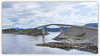

The above images may not be of the site on this page, but were taken nearby. They are loaded from Flickr so please click on them for image credits.
Click here to see more info for this site
Nearby sites
Click here to view sites on an interactive map of the areaKey: Red: member's photo, Blue: 3rd party photo, Yellow: other image, Green: no photo - please go there and take one, Grey: site destroyed
Download sites to:
KML (Google Earth)
GPX (GPS waypoints)
CSV (Garmin/Navman)
CSV (Excel)
To unlock full downloads you need to sign up as a Contributory Member. Otherwise downloads are limited to 50 sites.
Turn off the page maps and other distractions
Nearby sites listing. In the following links * = Image available
6.9km WSW 249° Sandvikshagen* Barrow Cemetery
12.2km WSW 246° Malefeten* Barrow Cemetery
13.1km SE 129° Håkonrøysa* Cairn
13.1km ENE 76° Søfstadklubben* Rock Art
21.2km SW 235° Gule* Standing Stone (Menhir)
21.3km E 91° Kvernes Tingsted* Stone Circle
22.6km E 100° Ikornneset* Barrow Cemetery
25.4km E 86° Frei Standing Stones* Standing Stones
25.5km SSW 214° Reithaugen Round Barrow(s)
27.1km SW 221° Hoksnes* Standing Stone (Menhir)
30.3km E 89° Aspa Standing Stones* Standing Stones
31.0km S 177° The Troll's Arrow* Standing Stone (Menhir)
31.0km S 177° Jutahaugen* Stone Circle
31.9km SW 218° Prestegardsskogen* Round Barrow(s)
32.9km SW 218° Tangen (Aukra)* Round Barrow(s)
33.7km SW 229° Korsbø-Smøla* Standing Stones
34.5km SSE 161° Horga Pagan Altar* Sculptured Stone
35.5km S 174° Nesje Standing Stones* Standing Stones
37.6km ENE 60° Linvågen* Standing Stone (Menhir)
45.0km S 180° Reiestad Standing Stone* Standing Stone (Menhir)
45.1km S 178° Grandan Mounds* Round Barrow(s)
45.8km S 191° Kråkneset Cairns* Cairn
46.5km ESE 111° Honnhammarneset* Rock Art
46.9km S 177° Våge standing stone* Standing Stone (Menhir)
47.3km ENE 67° Malivika standing stone* Standing Stone (Menhir)
View more nearby sites and additional images


 We would like to know more about this location. Please feel free to add a brief description and any relevant information in your own language.
 Wir möchten mehr über diese Stätte erfahren. Bitte zögern Sie nicht, eine kurze Beschreibung und relevante Informationen in Deutsch hinzuzufügen.
 Nous aimerions en savoir encore un peu sur les lieux. S'il vous plaît n'hesitez pas à ajouter une courte description et tous les renseignements pertinents dans votre propre langue.
 Quisieramos informarnos un poco más de las lugares. No dude en añadir una breve descripción y otros datos relevantes en su propio idioma.