

<< Our Photo Pages >> Oppidum Mont Vully - Ancient Village or Settlement in Switzerland in Freiburg
Submitted by wirzroland on Thursday, 14 March 2013 Page Views: 9827
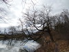
Multi-periodSite Name: Oppidum Mont VullyCountry: Switzerland
NOTE: This site is 8.918 km away from the location you searched for.
Canton: Freiburg Type: Ancient Village or Settlement
Nearest Town: Murten Nearest Village: Bas-Vully
Latitude: 46.961878N Longitude: 7.091956E
Condition:
| 5 | Perfect |
| 4 | Almost Perfect |
| 3 | Reasonable but with some damage |
| 2 | Ruined but still recognisable as an ancient site |
| 1 | Pretty much destroyed, possibly visible as crop marks |
| 0 | No data. |
| -1 | Completely destroyed |
| 5 | Superb |
| 4 | Good |
| 3 | Ordinary |
| 2 | Not Good |
| 1 | Awful |
| 0 | No data. |
| 5 | Can be driven to, probably with disabled access |
| 4 | Short walk on a footpath |
| 3 | Requiring a bit more of a walk |
| 2 | A long walk |
| 1 | In the middle of nowhere, a nightmare to find |
| 0 | No data. |
| 5 | co-ordinates taken by GPS or official recorded co-ordinates |
| 4 | co-ordinates scaled from a detailed map |
| 3 | co-ordinates scaled from a bad map |
| 2 | co-ordinates of the nearest village |
| 1 | co-ordinates of the nearest town |
| 0 | no data |
Internal Links:
External Links:
I have visited· I would like to visit
wirzroland has visited here
")
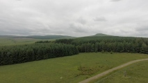
Keltisches Oppidum von Bas-Vully.
Dank archäologischen Ausgrabungen konnte das Oppidum originalgetreu nachgebaut werden.
You may be viewing yesterday's version of this page. To see the most up to date information please register for a free account.
")
")
")
")
Do not use the above information on other web sites or publications without permission of the contributor.
Nearby Images from Flickr


The above images may not be of the site on this page, but were taken nearby. They are loaded from Flickr so please click on them for image credits.
Click here to see more info for this site
Nearby sites
Click here to view sites on an interactive map of the areaKey: Red: member's photo, Blue: 3rd party photo, Yellow: other image, Green: no photo - please go there and take one, Grey: site destroyed
Download sites to:
KML (Google Earth)
GPX (GPS waypoints)
CSV (Garmin/Navman)
CSV (Excel)
To unlock full downloads you need to sign up as a Contributory Member. Otherwise downloads are limited to 50 sites.
Turn off the page maps and other distractions
Nearby sites listing. In the following links * = Image available
1.2km W 270° Agassiz Stein* Natural Stone / Erratic / Other Natural Feature
5.0km NNE 27° Findling (Schalenstein) Ins* Natural Stone / Erratic / Other Natural Feature
8.2km N 350° Teufelsbürdi* Natural Stone / Erratic / Other Natural Feature
8.3km N 356° Jolimont Schalensteine 3 Rock Art
8.3km N 357° Jolimont Grabhügelfeld Artificial Mound
8.4km N 356° Jolimont Schalensteine 2 Rock Art
8.5km N 356° Jolimont Schalensteine 1 Rock Art
10.4km WNW 299° Auvernier Dolmen* Chambered Tomb
10.4km WNW 299° Laténium Museum* Museum
10.4km WNW 299° Colombier Round Tomb* Round Cairn
11.5km NNW 346° Shell stone Le Landeron-Combes* Rock Art
16.8km W 273° Auvernier Schalenstein* Rock Art
17.9km NNE 22° Findling Holenstein* Natural Stone / Erratic / Other Natural Feature
18.4km S 175° Bois de Moncor Artificial Mound
18.6km NNE 23° Druidenstein Rock Art
21.9km W 259° Menhir Bevaix/Treytel* Modern Stone Circle etc
22.5km NE 42° Roman temple district Petinesca* Ancient Temple
22.7km NNE 30° Luterhölzli Schalenstein Rock Art
22.7km NNE 30° Brüggmöösli Schalenstein* Rock Art
22.8km NNE 30° Museum Schwab* Museum
23.0km W 260° Vauroux Menhir* Standing Stone (Menhir)
23.4km ENE 60° Grossaffoltern Schalenstein Rock Art
23.6km NE 35° Längholz Heidenstein Natural Stone / Erratic / Other Natural Feature
23.7km NE 35° Längholz Dachsenstein Rock Art
24.1km NE 35° Längholz Schalenstein Rock Art
View more nearby sites and additional images


 We would like to know more about this location. Please feel free to add a brief description and any relevant information in your own language.
 Wir möchten mehr über diese Stätte erfahren. Bitte zögern Sie nicht, eine kurze Beschreibung und relevante Informationen in Deutsch hinzuzufügen.
 Nous aimerions en savoir encore un peu sur les lieux. S'il vous plaît n'hesitez pas à ajouter une courte description et tous les renseignements pertinents dans votre propre langue.
 Quisieramos informarnos un poco más de las lugares. No dude en añadir una breve descripción y otros datos relevantes en su propio idioma.