


<< Our Photo Pages >> Drususfelsen - Rock Outcrop in Germany in Lower Saxony, Bremen
Submitted by Harald_Platta on Saturday, 28 November 2015 Page Views: 2428
Iron Age and Later PrehistorySite Name: Drususfelsen Alternative Name: TeufelsohrkissenCountry: Germany
NOTE: This site is 0.464 km away from the location you searched for.
Land: Lower Saxony, Bremen Type: Rock Outcrop
Nearest Town: Bad Bentheim
Latitude: 52.302679N Longitude: 7.155239E
Condition:
| 5 | Perfect |
| 4 | Almost Perfect |
| 3 | Reasonable but with some damage |
| 2 | Ruined but still recognisable as an ancient site |
| 1 | Pretty much destroyed, possibly visible as crop marks |
| 0 | No data. |
| -1 | Completely destroyed |
| 5 | Superb |
| 4 | Good |
| 3 | Ordinary |
| 2 | Not Good |
| 1 | Awful |
| 0 | No data. |
| 5 | Can be driven to, probably with disabled access |
| 4 | Short walk on a footpath |
| 3 | Requiring a bit more of a walk |
| 2 | A long walk |
| 1 | In the middle of nowhere, a nightmare to find |
| 0 | No data. |
| 5 | co-ordinates taken by GPS or official recorded co-ordinates |
| 4 | co-ordinates scaled from a detailed map |
| 3 | co-ordinates scaled from a bad map |
| 2 | co-ordinates of the nearest village |
| 1 | co-ordinates of the nearest town |
| 0 | no data |
Internal Links:
External Links:
I have visited· I would like to visit
XIII visited on 3rd Dec 2016 - their rating: Cond: 5 Amb: 4 Access: 5
Harald_Platta visited on 29th Apr 2011 - their rating: Cond: 5 Amb: 4 Access: 4
Average ratings for this site from all visit loggers: Condition: 5 Ambience: 4 Access: 4.5
")
The west side contains the inscription:"HIC DRUSUS DIXIT IURA TUBANTIBUS" ("Drusus spoke law to the Turbanti here"), indicating that the roman commander Drusus held court here over the Germanic tribe of the Turbanten. Even though this legend coined the name of the rock ("Drusus rock"), there is no evidence that Drusus has ever been in this area.
The second name (Teufelsohrkissen/"pillow of the devil`s ear" ) is linked to the legend concerning the construction of the nearby medieval Bentheim Castle. It was built so fast that some people thought that the devil must have helped. The devil was believed to have rested his head on the top of the rock.
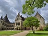
The castle is situated on a close by sandstone plateau, which is not much higher than the Drususfelsen. It is assumed that a pagan sanctuary was located at the position of today`s great hall, which is directly opposite of the Drususfelsen.
Literature:
[01] Warnecke, E.F.: Das große Buch der Burgen und Schlösser im Land von Hase und Ems (1980).
[02] Grimm, J., Grimm, W.: Das Teufelsohrkissen. In: Morgenblatt Nr.208 (1816).
You may be viewing yesterday's version of this page. To see the most up to date information please register for a free account.
")
")
Do not use the above information on other web sites or publications without permission of the contributor.
Nearby Images from Flickr
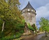


The above images may not be of the site on this page, but were taken nearby. They are loaded from Flickr so please click on them for image credits.
Click here to see more info for this site
Nearby sites
Click here to view sites on an interactive map of the areaKey: Red: member's photo, Blue: 3rd party photo, Yellow: other image, Green: no photo - please go there and take one, Grey: site destroyed
Download sites to:
KML (Google Earth)
GPX (GPS waypoints)
CSV (Garmin/Navman)
CSV (Excel)
To unlock full downloads you need to sign up as a Contributory Member. Otherwise downloads are limited to 50 sites.
Turn off the page maps and other distractions
Nearby sites listing. In the following links * = Image available
63m ESE 109° Herrgott von Bentheim* Ancient Cross
1.1km SW 215° Grabhügel Bad Bentheim FsNr. 1 Round Barrow(s)
10.9km W 281° Ludger Monument Bloemenbeek* Modern Stone Circle etc
11.0km WNW 283° De Lutte (45741) Ancient Village or Settlement
11.8km W 280° De Sproakstee* Modern Stone Circle etc
12.9km W 279° De Olifant* Natural Stone / Erratic / Other Natural Feature
12.9km SW 236° Grafheuvel Losser (45742)* Round Barrow(s)
13.4km SW 216° Gronauer Brocken* Natural Stone / Erratic / Other Natural Feature
13.8km NE 54° Mehringer Steine 3* Chambered Tomb
13.8km NE 54° Mehringer Steine 2* Chambered Tomb
13.8km NE 54° Mehringer Steine 1* Chambered Tomb
13.9km WNW 283° Grafheuvel Losser (45744) Round Barrow(s)
16.6km SSW 195° Hunenkerckhoff Barrow Cemetery
17.4km W 275° Grafheuvel Oldenzaal (45570)* Round Barrow(s)
17.9km E 98° Hünenborg Thieberg* Modern Stone Circle etc
18.6km W 274° Grafheuvels Oldenzaal (46006)* Round Barrow(s)
19.2km E 91° Rheine Megalithgrab* Passage Grave
19.5km WSW 245° Kei van O* Natural Stone / Erratic / Other Natural Feature
19.8km NE 46° Hesselte Steingrab Chambered Tomb
19.9km NE 47° Bramsche-Wesel Steingrab 1 Chambered Tomb
20.6km NE 51° Bramsche-Wesel Steingrab 3 Chambered Tomb
20.9km ESE 115° Am Hilgenfeld Barrow Cemetery
21.0km NE 38° Gleesen Steingrab* Chambered Tomb
21.2km E 93° Gräberfeld Altenrheine Barrow Cemetery
21.3km NW 309° Grafheuvels Oud Ootmarsum (45269) Round Barrow(s)
View more nearby sites and additional images


 We would like to know more about this location. Please feel free to add a brief description and any relevant information in your own language.
 Wir möchten mehr über diese Stätte erfahren. Bitte zögern Sie nicht, eine kurze Beschreibung und relevante Informationen in Deutsch hinzuzufügen.
 Nous aimerions en savoir encore un peu sur les lieux. S'il vous plaît n'hesitez pas à ajouter une courte description et tous les renseignements pertinents dans votre propre langue.
 Quisieramos informarnos un poco más de las lugares. No dude en añadir una breve descripción y otros datos relevantes en su propio idioma.