


<< Text Pages >> Grotte du Pourtegal - Cave or Rock Shelter in France in Provence:Alpes-Maritimes (06)
Submitted by AlexHunger on Tuesday, 07 June 2005 Page Views: 2216
Natural PlacesSite Name: Grotte du PourtegalCountry: France
NOTE: This site is 1.12 km away from the location you searched for.
Département: Provence:Alpes-Maritimes (06) Type: Cave or Rock Shelter
Nearest Town: Nice Nearest Village: Cipières
Latitude: 43.780350N Longitude: 6.969160E
Condition:
| 5 | Perfect |
| 4 | Almost Perfect |
| 3 | Reasonable but with some damage |
| 2 | Ruined but still recognisable as an ancient site |
| 1 | Pretty much destroyed, possibly visible as crop marks |
| 0 | No data. |
| -1 | Completely destroyed |
| 5 | Superb |
| 4 | Good |
| 3 | Ordinary |
| 2 | Not Good |
| 1 | Awful |
| 0 | No data. |
| 5 | Can be driven to, probably with disabled access |
| 4 | Short walk on a footpath |
| 3 | Requiring a bit more of a walk |
| 2 | A long walk |
| 1 | In the middle of nowhere, a nightmare to find |
| 0 | No data. |
| 5 | co-ordinates taken by GPS or official recorded co-ordinates |
| 4 | co-ordinates scaled from a detailed map |
| 3 | co-ordinates scaled from a bad map |
| 2 | co-ordinates of the nearest village |
| 1 | co-ordinates of the nearest town |
| 0 | no data |
Be the first person to rate this site - see the 'Contribute!' box in the right hand menu.
Internal Links:
External Links:
Cave in Alpes Maritime
IMPORTANT NOTE: Position of site unknown, co-ordinates given for nearest village. Bronze age
You may be viewing yesterday's version of this page. To see the most up to date information please register for a free account.
Do not use the above information on other web sites or publications without permission of the contributor.
Nearby Images from Flickr
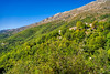
The above images may not be of the site on this page, but were taken nearby. They are loaded from Flickr so please click on them for image credits.
Click here to see more info for this site
Nearby sites
Click here to view sites on an interactive map of the areaKey: Red: member's photo, Blue: 3rd party photo, Yellow: other image, Green: no photo - please go there and take one, Grey: site destroyed
Download sites to:
KML (Google Earth)
GPX (GPS waypoints)
CSV (Garmin/Navman)
CSV (Excel)
To unlock full downloads you need to sign up as a Contributory Member. Otherwise downloads are limited to 50 sites.
Turn off the page maps and other distractions
Nearby sites listing. In the following links * = Image available
2.1km NNW 336° Grotte du Bord de la Route Cave or Rock Shelter
2.7km NW 307° L'Avaou Cave or Rock Shelter
6.4km SW 234° Grotte de Treppasses Cave or Rock Shelter
6.9km SSE 156° Dolmen de Cantracier Burial Chamber or Dolmen
7.1km SW 233° Aven Cresp Cave or Rock Shelter
7.6km WSW 240° Grotte des Morts Cave or Rock Shelter
8.0km S 176° Grotte du Revest Cave or Rock Shelter
8.5km S 183° Tumulus de la Saree Artificial Mound
8.6km S 175° Grotte de la Saree Cave or Rock Shelter
8.7km SE 127° Le Caire Tumulus Artificial Mound
10.5km SE 139° Baume Obscure Grotte Sepulcrale Cave or Rock Shelter
10.6km SW 218° Tombe en bloc de la Mala Graou Round Barrow(s)
11.1km SW 228° Tombe en bloc de la Colle Round Barrow(s)
11.1km ESE 116° Grotte Sepulcrale Chabert Cave or Rock Shelter
11.1km SW 218° Camp dit Castellaras de la Malle* Ancient Village or Settlement
11.3km SE 131° Grotte Sepulcrale de L'Aigle Cave or Rock Shelter
11.4km SSE 156° Dolmen des Peyraoutes* Burial Chamber or Dolmen
11.5km SSE 168° Le Castellaras Burial Chamber or Dolmen
11.6km ESE 110° Grotte Sepulcrale du Fenestron Cave or Rock Shelter
11.9km S 178° La pierre Haute Dolmen Burial Chamber or Dolmen
12.1km ESE 109° Dolmen des Blaquières Burial Chamber or Dolmen
12.2km ESE 114° Grotte Sepulcrale Des Perles Cave or Rock Shelter
12.3km SSW 213° Tombe en Bloc de Sainte-Anne No.1 Round Barrow(s)
12.4km SSW 212° Tombe en Bloc de Sainte-Anne No.3 Round Barrow(s)
12.4km SSW 211° Tombe en Bloc de Sainte-Anne No.4 Round Barrow(s)
View more nearby sites and additional images


 We would like to know more about this location. Please feel free to add a brief description and any relevant information in your own language.
 Wir möchten mehr über diese Stätte erfahren. Bitte zögern Sie nicht, eine kurze Beschreibung und relevante Informationen in Deutsch hinzuzufügen.
 Nous aimerions en savoir encore un peu sur les lieux. S'il vous plaît n'hesitez pas à ajouter une courte description et tous les renseignements pertinents dans votre propre langue.
 Quisieramos informarnos un poco más de las lugares. No dude en añadir una breve descripción y otros datos relevantes en su propio idioma.