


<< Text Pages >> Pierre du Diable (Manternach) - Modern Stone Circle etc in Luxembourg
Submitted by AlexHunger on Thursday, 13 October 2005 Page Views: 6087
Modern SitesSite Name: Pierre du Diable (Manternach) Alternative Name: GrauensteinCountry: Luxembourg
NOTE: This site is 4.234 km away from the location you searched for.
Type: Modern Stone Circle etc
Nearest Town: Luxemburg Nearest Village: Manternach
Latitude: 49.706100N Longitude: 6.431300E
Condition:
| 5 | Perfect |
| 4 | Almost Perfect |
| 3 | Reasonable but with some damage |
| 2 | Ruined but still recognisable as an ancient site |
| 1 | Pretty much destroyed, possibly visible as crop marks |
| 0 | No data. |
| -1 | Completely destroyed |
| 5 | Superb |
| 4 | Good |
| 3 | Ordinary |
| 2 | Not Good |
| 1 | Awful |
| 0 | No data. |
| 5 | Can be driven to, probably with disabled access |
| 4 | Short walk on a footpath |
| 3 | Requiring a bit more of a walk |
| 2 | A long walk |
| 1 | In the middle of nowhere, a nightmare to find |
| 0 | No data. |
| 5 | co-ordinates taken by GPS or official recorded co-ordinates |
| 4 | co-ordinates scaled from a detailed map |
| 3 | co-ordinates scaled from a bad map |
| 2 | co-ordinates of the nearest village |
| 1 | co-ordinates of the nearest town |
| 0 | no data |
Internal Links:
External Links:
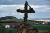
The Groensteen is not a Dolmen, but a romantic stone construction from the the nineteenth century. The same goes for the nearby cromlech.
Translates to Devil stone of horror stone respectively in French and in German. Capstone measuring 3 Meters long, 2 Meters wide and 50 cm thick, restored with iron bands to hold it together. On hill on road between Manternach and Munschecker.
IMPORTANT NOTE: Site believed to be near this position.
You may be viewing yesterday's version of this page. To see the most up to date information please register for a free account.
Do not use the above information on other web sites or publications without permission of the contributor.
Nearby Images from Flickr
The above images may not be of the site on this page, but were taken nearby. They are loaded from Flickr so please click on them for image credits.
Click here to see more info for this site
Nearby sites
Click here to view sites on an interactive map of the areaKey: Red: member's photo, Blue: 3rd party photo, Yellow: other image, Green: no photo - please go there and take one, Grey: site destroyed
Download sites to:
KML (Google Earth)
GPX (GPS waypoints)
CSV (Garmin/Navman)
CSV (Excel)
To unlock full downloads you need to sign up as a Contributory Member. Otherwise downloads are limited to 50 sites.
Turn off the page maps and other distractions
Nearby sites listing. In the following links * = Image available
5.7km E 87° Heidenborn Oberbillig Holy Well or Sacred Spring
7.3km SE 129° Tempelbezirk Tawern* Ancient Temple
9.7km NW 310° Steebaachtal Polissoir* Polissoir
9.9km E 95° Archaische Spuren* Modern Stone Circle etc
10.3km NW 310° Ginstegestell* Ancient Village or Settlement
10.5km E 99° Weisser Wacken* Standing Stone (Menhir)
12.0km N 357° Willibrordus Brunnen Echternach* Holy Well or Sacred Spring
12.0km NE 39° Kersch Grabhügelgruppe Barrow Cemetery
12.6km WNW 300° Loschbur* Natural Stone / Erratic / Other Natural Feature
13.0km NW 321° Keltenhiel* Cave or Rock Shelter
13.1km NW 316° De Schwaarze Mann* Rock Art
13.3km NW 325° Schnellert Pseudo-Dolmen* Burial Chamber or Dolmen
13.6km NE 35° Langenstein Olk Rock Outcrop
13.9km ENE 68° Heideborn* Holy Well or Sacred Spring
14.8km N 351° Schweigestelle* Carving
15.2km NNW 347° Dianadenkmal* Rock Art
15.4km NNW 348° Bollendorf Opferaltar* Natural Stone / Erratic / Other Natural Feature
15.5km W 279° Schleifrillen Häerdcheslee* Polissoir
15.6km W 279° La Roche des Payens* Rock Art
15.6km NNW 348° Niederburg Bollendorf* Hillfort
15.7km W 279° Freylay* Natural Stone / Erratic / Other Natural Feature
16.2km ENE 72° Rheinisches Landesmuseum Trier* Museum
16.2km ENE 70° Domstein Trier* Early Christian Sculptured Stone
16.3km NE 37° Grabhügelfeld Olk Barrow Cemetery
16.3km ENE 73° Trier Roman Amphitheatre* Ancient Village or Settlement
View more nearby sites and additional images


 We would like to know more about this location. Please feel free to add a brief description and any relevant information in your own language.
 Wir möchten mehr über diese Stätte erfahren. Bitte zögern Sie nicht, eine kurze Beschreibung und relevante Informationen in Deutsch hinzuzufügen.
 Nous aimerions en savoir encore un peu sur les lieux. S'il vous plaît n'hesitez pas à ajouter une courte description et tous les renseignements pertinents dans votre propre langue.
 Quisieramos informarnos un poco más de las lugares. No dude en añadir una breve descripción y otros datos relevantes en su propio idioma.