

<< Our Photo Pages >> D1 Steenbergen - Passage Grave in Netherlands in Drenthe
Submitted by Sunflowerbird on Thursday, 15 February 2001 Page Views: 6466
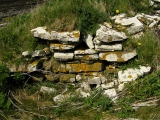
Neolithic and Bronze AgeSite Name: D1 SteenbergenCountry: Netherlands
NOTE: This site is 3.77 km away from the location you searched for.
Province: Drenthe Type: Passage Grave
Nearest Town: Assen Nearest Village: Roden
Latitude: 53.104888N Longitude: 6.410473E
Condition:
| 5 | Perfect |
| 4 | Almost Perfect |
| 3 | Reasonable but with some damage |
| 2 | Ruined but still recognisable as an ancient site |
| 1 | Pretty much destroyed, possibly visible as crop marks |
| 0 | No data. |
| -1 | Completely destroyed |
| 5 | Superb |
| 4 | Good |
| 3 | Ordinary |
| 2 | Not Good |
| 1 | Awful |
| 0 | No data. |
| 5 | Can be driven to, probably with disabled access |
| 4 | Short walk on a footpath |
| 3 | Requiring a bit more of a walk |
| 2 | A long walk |
| 1 | In the middle of nowhere, a nightmare to find |
| 0 | No data. |
| 5 | co-ordinates taken by GPS or official recorded co-ordinates |
| 4 | co-ordinates scaled from a detailed map |
| 3 | co-ordinates scaled from a bad map |
| 2 | co-ordinates of the nearest village |
| 1 | co-ordinates of the nearest town |
| 0 | no data |
Internal Links:
External Links:
I have visited· I would like to visit
DrewParsons would like to visit
johnstone visited on 22nd Jun 2021 - their rating: Cond: 4 Amb: 4 Access: 5
Podovsky visited on 4th Mar 2019 - their rating: Cond: 4 Amb: 4 Access: 5
XIII visited on 29th Apr 2018 - their rating: Cond: 4 Amb: 4 Access: 4
johnstone visited on 16th Apr 2005 - their rating: Cond: 4 Amb: 4 Access: 5
Alta-Falisa Martin_L have visited here
Average ratings for this site from all visit loggers: Condition: 4 Ambience: 4 Access: 4.75
")
Easy access by car, nearly next to it (Google Map it).
Like [nearly] all hunebedden (passage graves), this one has been restored in the years 1920 by Prof. A van Giffen.
In 2012 new information panels where placed near the hunebedden, showing information in Dutch on one side, and the same information in English on the other side.
More ? (Wikiwand in Dutch) Hunebedden
Monumentenregister (Historic Monument)
Hunebeddeninfo (Dutch Information)
Short info (Site Hans Meijer)
Note : All hunebedden are now clearly signposted from the nearest road, but you do not find them by chance. Count three days to visit them all, by car.
You may be viewing yesterday's version of this page. To see the most up to date information please register for a free account.
")
")
")
")
")
")
")
")
")
")
")
")
")
")
")
Do not use the above information on other web sites or publications without permission of the contributor.
Click here to see more info for this site
Nearby sites
Click here to view sites on an interactive map of the areaKey: Red: member's photo, Blue: 3rd party photo, Yellow: other image, Green: no photo - please go there and take one, Grey: site destroyed
Download sites to:
KML (Google Earth)
GPX (GPS waypoints)
CSV (Garmin/Navman)
CSV (Excel)
To unlock full downloads you need to sign up as a Contributory Member. Otherwise downloads are limited to 50 sites.
![]()
![]()
Turn off the page maps and other distractions
Nearby sites listing. In the following links * = Image available
5.5km SE 142° Norg Kerk Hunebed* Natural Stone / Erratic / Other Natural Feature
6.0km SSE 157° D2 Westervelde* Passage Grave
9.1km SW 228° Waskemeer (45870) Ancient Village or Settlement
9.4km SW 229° Waskemeer (45871) Ancient Village or Settlement
9.4km ESE 121° D5 Zeijen* Passage Grave
10.1km NW 308° Zwerfsteen Mienscheer* Natural Stone / Erratic / Other Natural Feature
10.3km SW 232° Waskemeer (45872) Ancient Village or Settlement
10.3km SW 232° Oosterwolde (45877) Ancient Village or Settlement
10.3km SW 232° Donkerbroek (45873) Ancient Village or Settlement
11.5km SSW 212° Oosterwolde (45874) Ancient Village or Settlement
11.7km ESE 106° Zwerfsteen Vries* Natural Stone / Erratic / Other Natural Feature
11.7km E 94° Gebroken Cirkel* Modern Stone Circle etc
12.2km ENE 71° Grafheuvel Eelde (45394) Round Barrow(s)
14.3km SW 223° Donkerbroek (45875) Ancient Village or Settlement
15.0km ESE 103° D6 Tynaarlo* Passage Grave
15.5km ENE 78° G3 Glimmer Es* Chambered Tomb
15.6km ENE 79° G2 Glimmer Es Passage Grave
16.1km E 89° Grafheuvels Midlaren (45569) Round Barrow(s)
16.1km SE 140° Drents Museum* Museum
16.1km ENE 71° G4 Onner Es Chambered Tomb
16.3km SE 124° D15 Loon* Passage Grave
16.4km E 91° Grafheuvels Midlaren (45399) Round Barrow(s)
16.6km E 86° G1 Noordlaren* Passage Grave
17.4km E 89° D3 Midlaren* Passage Grave
17.5km E 89° D4 Midlaren* Passage Grave
View more nearby sites and additional images


 We would like to know more about this location. Please feel free to add a brief description and any relevant information in your own language.
 Wir möchten mehr über diese Stätte erfahren. Bitte zögern Sie nicht, eine kurze Beschreibung und relevante Informationen in Deutsch hinzuzufügen.
 Nous aimerions en savoir encore un peu sur les lieux. S'il vous plaît n'hesitez pas à ajouter une courte description et tous les renseignements pertinents dans votre propre langue.
 Quisieramos informarnos un poco más de las lugares. No dude en añadir una breve descripción y otros datos relevantes en su propio idioma.