


<< Our Photo Pages >> Watzerath - Modern Stone Circle etc in Germany in Rhineland-Palatinate
Submitted by Alta-Falisa on Friday, 09 September 2016 Page Views: 1137
Modern SitesSite Name: WatzerathCountry: Germany Land: Rhineland-Palatinate Type: Modern Stone Circle etc
Nearest Town: Prüm Nearest Village: Watzerath
Latitude: 50.183500N Longitude: 6.360900E
Condition:
| 5 | Perfect |
| 4 | Almost Perfect |
| 3 | Reasonable but with some damage |
| 2 | Ruined but still recognisable as an ancient site |
| 1 | Pretty much destroyed, possibly visible as crop marks |
| 0 | No data. |
| -1 | Completely destroyed |
| 5 | Superb |
| 4 | Good |
| 3 | Ordinary |
| 2 | Not Good |
| 1 | Awful |
| 0 | No data. |
| 5 | Can be driven to, probably with disabled access |
| 4 | Short walk on a footpath |
| 3 | Requiring a bit more of a walk |
| 2 | A long walk |
| 1 | In the middle of nowhere, a nightmare to find |
| 0 | No data. |
| 5 | co-ordinates taken by GPS or official recorded co-ordinates |
| 4 | co-ordinates scaled from a detailed map |
| 3 | co-ordinates scaled from a bad map |
| 2 | co-ordinates of the nearest village |
| 1 | co-ordinates of the nearest town |
| 0 | no data |
Internal Links:
External Links:
")
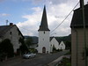
Modern decorative slab, looking like a standing stone quite common further West all the way up to the Atlantic Shores.
You may be viewing yesterday's version of this page. To see the most up to date information please register for a free account.
")
")
Do not use the above information on other web sites or publications without permission of the contributor.
Nearby Images from Flickr

The above images may not be of the site on this page, but were taken nearby. They are loaded from Flickr so please click on them for image credits.
Click here to see more info for this site
Nearby sites
Click here to view sites on an interactive map of the areaKey: Red: member's photo, Blue: 3rd party photo, Yellow: other image, Green: no photo - please go there and take one, Grey: site destroyed
Download sites to:
KML (Google Earth)
GPX (GPS waypoints)
CSV (Garmin/Navman)
CSV (Excel)
To unlock full downloads you need to sign up as a Contributory Member. Otherwise downloads are limited to 50 sites.
Turn off the page maps and other distractions
Nearby sites listing. In the following links * = Image available
5.2km ENE 61° Weissenstein* Standing Stone (Menhir)
8.4km N 358° Forstmeister-Jansen-Stein* Standing Stone (Menhir)
9.1km E 100° Altburg Niederhersdorf* Hillfort
11.1km ENE 75° Fleringen Menhir* Standing Stone (Menhir)
11.1km SW 226° Menhir Binscheid* Standing Stone (Menhir)
11.8km ENE 77° Langstein bei Wallersheim* Standing Stone (Menhir)
13.8km SW 235° Menhir von Eschfeld* Standing Stone (Menhir)
16.3km ENE 75° Buedesheim Rotley Natural Stone / Erratic / Other Natural Feature
20.2km NW 323° Meyerode Kreuzstein Early Christian Sculptured Stone
21.0km ENE 77° Auberg Felsformation Natural Stone / Erratic / Other Natural Feature
21.6km ENE 77° Magdalena Höhle Cave or Rock Shelter
21.9km ENE 76° Buchenloch Hoehle* Cave or Rock Shelter
22.7km E 85° Dietzenley Hillfort
22.9km ENE 77° Judenkirchhof Pelm* Ancient Temple
23.1km ENE 77° Hedenborn Holy Well or Sacred Spring
25.7km N 360° Weißer Stein* Natural Stone / Erratic / Other Natural Feature
28.4km E 101° Burgberg Schutz* Hillfort
28.6km NW 323° Menhir d'Ondenval* Modern Stone Circle etc
29.1km ENE 73° Hünenstein Betteldorf* Standing Stone (Menhir)
29.7km ENE 77° Der Spitze Stein von Hinterweiler* Standing Stone (Menhir)
30.4km NE 36° Düwelsteen Ripsdorfer Wald* Rock Outcrop
30.5km NE 37° Düwelskall* Cave or Rock Shelter
31.0km S 176° Hartberg Steinkistengrab* Chambered Tomb
32.1km ENE 79° Huegelgraeberfeld Dockweiler Wald* Barrow Cemetery
33.0km NE 34° Grabhügel Hängebuche* Round Barrow(s)
View more nearby sites and additional images


 We would like to know more about this location. Please feel free to add a brief description and any relevant information in your own language.
 Wir möchten mehr über diese Stätte erfahren. Bitte zögern Sie nicht, eine kurze Beschreibung und relevante Informationen in Deutsch hinzuzufügen.
 Nous aimerions en savoir encore un peu sur les lieux. S'il vous plaît n'hesitez pas à ajouter une courte description et tous les renseignements pertinents dans votre propre langue.
 Quisieramos informarnos un poco más de las lugares. No dude en añadir una breve descripción y otros datos relevantes en su propio idioma.