

<< Our Photo Pages >> Byrkjehaugen - Round Barrow(s) in Norway in Hordaland
Submitted by kenntha88 on Monday, 24 September 2012 Page Views: 1582
Neolithic and Bronze AgeSite Name: ByrkjehaugenCountry: Norway
NOTE: This site is 18.989 km away from the location you searched for.
Fylke: Hordaland Type: Round Barrow(s)
Nearest Town: Voss
Latitude: 60.624163N Longitude: 6.323061E
Condition:
| 5 | Perfect |
| 4 | Almost Perfect |
| 3 | Reasonable but with some damage |
| 2 | Ruined but still recognisable as an ancient site |
| 1 | Pretty much destroyed, possibly visible as crop marks |
| 0 | No data. |
| -1 | Completely destroyed |
| 5 | Superb |
| 4 | Good |
| 3 | Ordinary |
| 2 | Not Good |
| 1 | Awful |
| 0 | No data. |
| 5 | Can be driven to, probably with disabled access |
| 4 | Short walk on a footpath |
| 3 | Requiring a bit more of a walk |
| 2 | A long walk |
| 1 | In the middle of nowhere, a nightmare to find |
| 0 | No data. |
| 5 | co-ordinates taken by GPS or official recorded co-ordinates |
| 4 | co-ordinates scaled from a detailed map |
| 3 | co-ordinates scaled from a bad map |
| 2 | co-ordinates of the nearest village |
| 1 | co-ordinates of the nearest town |
| 0 | no data |
Internal Links:
External Links:
")
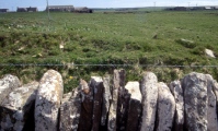
Byrkjehaugen is a large round barrow located on a steep hill going south towards the river. The mound is between the highway to the south and the railway line to the north.
The mound is one of the largest barrows in western Norway. The original mound size was around 50 metres in diameter and 5 metres in height. Excavations in 1903 and railway and highway construction have damaged the mound in later years, so the dimensions today are around 37 metres in diameter and around 4 metres high.
The mound contained three burials that were all dated to around the age of migration (around 400AD). The upper grave was a male grave. The buried man was lying on bear skin. Under the male burial was the remains of a cremation burial of a woman, she was also packed in bear skin before cremation. The bottom burial was an unburned female burial. Parts of the bones were intact. Also found were bear skin and pieces of fabric. In all three burials were found parts of the same pottery, and there was little difference between the three burials. This has lead to the theory that the mound was a family burial mound used for several generations, instead of the more common burial where individuals were laid in individual barrows.
You may be viewing yesterday's version of this page. To see the most up to date information please register for a free account.
")
Do not use the above information on other web sites or publications without permission of the contributor.
Nearby Images from Flickr
The above images may not be of the site on this page, but were taken nearby. They are loaded from Flickr so please click on them for image credits.
Click here to see more info for this site
Nearby sites
Click here to view sites on an interactive map of the areaKey: Red: member's photo, Blue: 3rd party photo, Yellow: other image, Green: no photo - please go there and take one, Grey: site destroyed
Download sites to:
KML (Google Earth)
GPX (GPS waypoints)
CSV (Garmin/Navman)
CSV (Excel)
To unlock full downloads you need to sign up as a Contributory Member. Otherwise downloads are limited to 50 sites.
Turn off the page maps and other distractions
Nearby sites listing. In the following links * = Image available
2.6km ESE 103° Kvåle* Cist
2.8km ESE 104° Ormshaugen* Round Barrow(s)
5.8km ENE 78° Rogne* Round Barrow(s)
9.4km ENE 77° Vetlehaugen* Round Barrow(s)
10.9km ENE 62° Reppavegen* Round Barrow(s)
12.2km ENE 77° Sledasteinen* Rock Art
12.7km NE 44° Grjotland* Barrow Cemetery
19.3km NNE 26° Runakollane* Cairn
21.1km NNE 29° Draugsvoll* Round Barrow(s)
23.2km ESE 108° Bårstesteinen* Standing Stone (Menhir)
23.3km ESE 107° Endrehaugen* Round Barrow(s)
24.6km ESE 115° Kjerland* Round Barrow(s)
25.1km S 187° Krakahaugen* Round Barrow(s)
25.3km SSE 152° Lothe (Utne)* Round Barrow(s)
25.9km S 184° Leirhaug* Round Barrow(s)
26.9km S 185° Rykkje* Rock Art
26.9km NE 41° Tinghaugane* Round Barrow(s)
27.0km S 185° Bjelkanes* Cairn
27.7km NE 42° Lundahovden* Round Barrow(s)
29.7km SSW 199° Grova* Round Barrow(s)
31.2km S 174° Bakke-Kalhagen Helleristning * Rock Art
31.7km S 175° Vik-Gamlenaustet* Ancient Village or Settlement
33.0km SSE 149° Håhaugsteinen Helleristninger* Rock Art
34.0km SSW 192° Salthammeren Stone Age Carvings* Rock Art
34.1km SSW 192° Salthammeren Bronze Age Carvings* Rock Art
View more nearby sites and additional images


 We would like to know more about this location. Please feel free to add a brief description and any relevant information in your own language.
 Wir möchten mehr über diese Stätte erfahren. Bitte zögern Sie nicht, eine kurze Beschreibung und relevante Informationen in Deutsch hinzuzufügen.
 Nous aimerions en savoir encore un peu sur les lieux. S'il vous plaît n'hesitez pas à ajouter une courte description et tous les renseignements pertinents dans votre propre langue.
 Quisieramos informarnos un poco más de las lugares. No dude en añadir una breve descripción y otros datos relevantes en su propio idioma.