


<< Our Photo Pages >> Khor Rori - Ancient Village or Settlement in Oman
Submitted by ilsignorstano on Sunday, 22 December 2013 Page Views: 5112
Multi-periodSite Name: Khor Rori Alternative Name: SumhuramCountry: Oman
NOTE: This site is 30.554 km away from the location you searched for.
Type: Ancient Village or Settlement
Nearest Town: Salalah Nearest Village: Taqah
Latitude: 17.039670N Longitude: 54.438730E
Condition:
| 5 | Perfect |
| 4 | Almost Perfect |
| 3 | Reasonable but with some damage |
| 2 | Ruined but still recognisable as an ancient site |
| 1 | Pretty much destroyed, possibly visible as crop marks |
| 0 | No data. |
| -1 | Completely destroyed |
| 5 | Superb |
| 4 | Good |
| 3 | Ordinary |
| 2 | Not Good |
| 1 | Awful |
| 0 | No data. |
| 5 | Can be driven to, probably with disabled access |
| 4 | Short walk on a footpath |
| 3 | Requiring a bit more of a walk |
| 2 | A long walk |
| 1 | In the middle of nowhere, a nightmare to find |
| 0 | No data. |
| 5 | co-ordinates taken by GPS or official recorded co-ordinates |
| 4 | co-ordinates scaled from a detailed map |
| 3 | co-ordinates scaled from a bad map |
| 2 | co-ordinates of the nearest village |
| 1 | co-ordinates of the nearest town |
| 0 | no data |
Internal Links:
External Links:
")
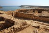
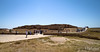
Khor Rori is an early South Arabian archaeological site adjacent to the lagoon on the coastal strip in the Taqa region, 40 kms east of Salalah. The small fortified town and port was founded as an outpost for the kingdom of Hadramawt in modern Yemen once the Nabataeans started to export frankincense from the Hymraite ports.The site shows signs of Hadrami settlement back to the third century CE and the settlement was probably abandoned in the seventh century.
Inscriptions at Khor Rori reports that the town, called "Sumhuram", was founded on royal initiative and settled by Hadrami emigrants. Dhofar was the main source of frankincense in the ancient period, and it seems likely that the foundation of the settlement was in part motivated by a Hadrami wish to control the production of this valuable commodity. Most scholars identify Khor Rori with the frankincense exporting port of Moscha Limen mentioned in this region in the 1st century maritime guide Periplus Maris Erythraei. The great gate of the town indicates that the citadel had an outer wall with towers and three gates, and that its main entrance was protected by square towers. It contained an inner structure which may have been a temple or castle consisting of large frankincense stores. Other finds include coins, earthenware pots, bronze objects, and a 21 cm high incense burner.
References:
Sultanate of Oman, Ministry of information
Nabatea website
You may be viewing yesterday's version of this page. To see the most up to date information please register for a free account.
")
")
")
")
Do not use the above information on other web sites or publications without permission of the contributor.
Nearby Images from Flickr
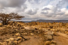
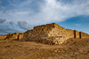
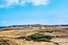
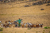
The above images may not be of the site on this page, but were taken nearby. They are loaded from Flickr so please click on them for image credits.
Click here to see more info for this site
Nearby sites
Click here to view sites on an interactive map of the areaKey: Red: member's photo, Blue: 3rd party photo, Yellow: other image, Green: no photo - please go there and take one, Grey: site destroyed
Download sites to:
KML (Google Earth)
GPX (GPS waypoints)
CSV (Garmin/Navman)
CSV (Excel)
To unlock full downloads you need to sign up as a Contributory Member. Otherwise downloads are limited to 50 sites.
Turn off the page maps and other distractions
Nearby sites listing. In the following links * = Image available
668.3km NNW 338° Al Ahsa Temple Ancient Temple
733.3km NNE 19° Al-Khutm Tower Stone Fort or Dun
733.4km NNE 19° Bat. Ancient Village or Settlement
735.6km NNE 21° Qubur Juhhal Beehive Tombs* Chambered Tomb
790.5km NNE 11° Mezyad graves Burial Chamber or Dolmen
791.8km N 10° Jebel Hafit Cairn Tombs* Burial Chamber or Dolmen
817.3km N 351° Marawah Neolithic Village* Ancient Village or Settlement
818.8km N 10° Al Hili Archaeological park* Museum
819.2km N 1° Umm al-Nar tomb Burial Chamber or Dolmen
822.5km NE 42° Ras Al Jinz* Museum
824.6km N 9° Bida Bint Saud Burial Chamber or Dolmen
824.7km N 0° Umm al-Nar Cairn Chambered Cairn
827.0km NE 42° Ras Al Had* Ancient Village or Settlement
897.5km N 9° Al-Buhais 18 Ancient Village or Settlement
903.6km N 5° al-Sufouh* Chambered Cairn
910.2km N 9° Jebel Faya Rock Shelter Cave or Rock Shelter
910.4km N 9° Mleiha Fort Stone Fort or Dun
910.5km N 9° Jebel Faya tomb 3 Chambered Tomb
910.6km N 9° Jebel Faya tomb 1* Chambered Tomb
910.6km N 9° Jebel Faya tomb 2 Chambered Tomb
910.6km N 9° Wadi Caves* Cave or Rock Shelter
910.7km N 9° FAY-NE-15* Ancient Village or Settlement
911.2km N 9° Mleiha Archaeological Centre* Museum
911.2km N 9° Mleiha Umm an-Nar tomb* Chambered Tomb
918.8km N 5° Dubai Museum* Museum
View more nearby sites and additional images


 We would like to know more about this location. Please feel free to add a brief description and any relevant information in your own language.
 Wir möchten mehr über diese Stätte erfahren. Bitte zögern Sie nicht, eine kurze Beschreibung und relevante Informationen in Deutsch hinzuzufügen.
 Nous aimerions en savoir encore un peu sur les lieux. S'il vous plaît n'hesitez pas à ajouter une courte description et tous les renseignements pertinents dans votre propre langue.
 Quisieramos informarnos un poco más de las lugares. No dude en añadir una breve descripción y otros datos relevantes en su propio idioma.