 with our Megalithic Portal iPhone app")


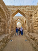
<< Text Pages >> Al Hajar - Barrow Cemetery in Bahrain
Submitted by Klingon on Friday, 02 October 2009 Page Views: 3749
Neolithic and Bronze AgeSite Name: Al HajarCountry: Bahrain
NOTE: This site is 2.056 km away from the location you searched for.
Type: Barrow Cemetery
Latitude: 26.216683N Longitude: 50.514947E
Condition:
| 5 | Perfect |
| 4 | Almost Perfect |
| 3 | Reasonable but with some damage |
| 2 | Ruined but still recognisable as an ancient site |
| 1 | Pretty much destroyed, possibly visible as crop marks |
| 0 | No data. |
| -1 | Completely destroyed |
| 5 | Superb |
| 4 | Good |
| 3 | Ordinary |
| 2 | Not Good |
| 1 | Awful |
| 0 | No data. |
| 5 | Can be driven to, probably with disabled access |
| 4 | Short walk on a footpath |
| 3 | Requiring a bit more of a walk |
| 2 | A long walk |
| 1 | In the middle of nowhere, a nightmare to find |
| 0 | No data. |
| 5 | co-ordinates taken by GPS or official recorded co-ordinates |
| 4 | co-ordinates scaled from a detailed map |
| 3 | co-ordinates scaled from a bad map |
| 2 | co-ordinates of the nearest village |
| 1 | co-ordinates of the nearest town |
| 0 | no data |
Be the first person to rate this site - see the 'Contribute!' box in the right hand menu.
Internal Links:
External Links:
Barrow Cemetery in Bahrain
Burial Ensembles of Dilmun and Tylos
You may be viewing yesterday's version of this page. To see the most up to date information please register for a free account.
Do not use the above information on other web sites or publications without permission of the contributor.
Nearby Images from Flickr
The above images may not be of the site on this page, but were taken nearby. They are loaded from Flickr so please click on them for image credits.
Click here to see more info for this site
Nearby sites
Click here to view sites on an interactive map of the areaKey: Red: member's photo, Blue: 3rd party photo, Yellow: other image, Green: no photo - please go there and take one, Grey: site destroyed
Download sites to:
KML (Google Earth)
GPX (GPS waypoints)
CSV (Garmin/Navman)
CSV (Excel)
To unlock full downloads you need to sign up as a Contributory Member. Otherwise downloads are limited to 50 sites.
Turn off the page maps and other distractions
Nearby sites listing. In the following links * = Image available
1.4km WSW 257° Shakhurah Barrow Cemetery
1.9km NNE 22° Dilmun Ancient Village or Settlement
2.6km WNW 298° Jannusan Barrow Cemetery
3.3km WNW 289° Barbar Temple Ancient Temple
4.8km SSW 210° Dilmun Monuments and Settlement* Ancient Village or Settlement
5.8km SW 226° Janabiyah Barrow Cemetery
7.5km S 183° cultural landscape of Ali Barrow Cemetery
8.6km S 188° Buri Burial Mounds* Barrow Cemetery
10.2km S 179° Wadi as-Sail Barrow Cemetery
10.7km S 189° Karzakkan Barrow Cemetery
15.8km S 184° Dar Kulayb Barrow Cemetery
22.2km S 179° Umm-Jidr Barrow Cemetery
60.7km NW 324° Jawan Chambered Tomb Chambered Tomb
146.4km SE 135° National Museum of Qatar* Museum
264.0km SSW 212° Yabrin Burial Mounds* Cairn
337.8km N 357° Kharg Island Rock Art
344.6km SE 128° Marawah Neolithic Village* Ancient Village or Settlement
370.5km NE 44° Yasouj Ancient Village or Settlement
409.7km NNE 14° Bishapur* Ancient Village or Settlement
429.7km SSE 159° Al Ahsa Temple Ancient Temple
445.8km ESE 115° Umm al-Nar Cairn Chambered Cairn
451.7km ESE 116° Umm al-Nar tomb Burial Chamber or Dolmen
456.2km NNE 27° Gondashlu Stone Quarry Ancient Mine, Quarry or other Industry
465.7km NNE 28° Mianroud Mound Ancient Village or Settlement
472.3km NNE 29° Tall-e Bakun* Ancient Village or Settlement
View more nearby sites and additional images


 We would like to know more about this location. Please feel free to add a brief description and any relevant information in your own language.
 Wir möchten mehr über diese Stätte erfahren. Bitte zögern Sie nicht, eine kurze Beschreibung und relevante Informationen in Deutsch hinzuzufügen.
 Nous aimerions en savoir encore un peu sur les lieux. S'il vous plaît n'hesitez pas à ajouter une courte description et tous les renseignements pertinents dans votre propre langue.
 Quisieramos informarnos un poco más de las lugares. No dude en añadir una breve descripción y otros datos relevantes en su propio idioma.