


<< Our Photo Pages >> Gjerde standing stone - Standing Stone (Menhir) in Norway in Hordaland
Submitted by kenntha88 on Thursday, 13 September 2012 Page Views: 1915
Neolithic and Bronze AgeSite Name: Gjerde standing stoneCountry: Norway
NOTE: This site is 0.321 km away from the location you searched for.
Fylke: Hordaland Type: Standing Stone (Menhir)
Nearest Village: Gjerde
Latitude: 59.663893N Longitude: 5.934892E
Condition:
| 5 | Perfect |
| 4 | Almost Perfect |
| 3 | Reasonable but with some damage |
| 2 | Ruined but still recognisable as an ancient site |
| 1 | Pretty much destroyed, possibly visible as crop marks |
| 0 | No data. |
| -1 | Completely destroyed |
| 5 | Superb |
| 4 | Good |
| 3 | Ordinary |
| 2 | Not Good |
| 1 | Awful |
| 0 | No data. |
| 5 | Can be driven to, probably with disabled access |
| 4 | Short walk on a footpath |
| 3 | Requiring a bit more of a walk |
| 2 | A long walk |
| 1 | In the middle of nowhere, a nightmare to find |
| 0 | No data. |
| 5 | co-ordinates taken by GPS or official recorded co-ordinates |
| 4 | co-ordinates scaled from a detailed map |
| 3 | co-ordinates scaled from a bad map |
| 2 | co-ordinates of the nearest village |
| 1 | co-ordinates of the nearest town |
| 0 | no data |
Internal Links:
External Links:
")
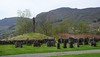
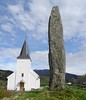
Inside the modern cemetery of Gjerde in the middle of the small village is a tall and beautiful standing stone.
The standing stone is almost vertically and with no tilting to either side. It is around 6 metres in height and around 40cm wide across. It has a very nice rounded cross-section.
The surface is very smooth compared to many other menhirs and the top ends in a sharp point. In modern times, someone has carved a cross almost at the top of the stone.
You may be viewing yesterday's version of this page. To see the most up to date information please register for a free account.
")
")
")
")
Do not use the above information on other web sites or publications without permission of the contributor.
Nearby Images from Flickr
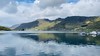
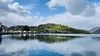
The above images may not be of the site on this page, but were taken nearby. They are loaded from Flickr so please click on them for image credits.
Click here to see more info for this site
Nearby sites
Click here to view sites on an interactive map of the areaKey: Red: member's photo, Blue: 3rd party photo, Yellow: other image, Green: no photo - please go there and take one, Grey: site destroyed
Download sites to:
KML (Google Earth)
GPX (GPS waypoints)
CSV (Garmin/Navman)
CSV (Excel)
To unlock full downloads you need to sign up as a Contributory Member. Otherwise downloads are limited to 50 sites.
Turn off the page maps and other distractions
Nearby sites listing. In the following links * = Image available
2.0km ENE 59° Kyrkjehaugen* Standing Stone (Menhir)
2.2km ENE 58° Helgaberget Helleristninger* Rock Art
3.9km E 80° Grindheim Runestone* Carving
3.9km E 81° Grindheim stone cross* Ancient Cross
13.0km ENE 65° Bruteigsteinen* Rock Art
13.6km SSW 204° Østabøstødl - Rabbadn* Barrow Cemetery
18.2km S 185° Hundehaugene* Standing Stone (Menhir)
18.2km W 275° Bjoavågen* Carving
18.7km W 278° Utbjoa* Cairn
19.3km NW 319° Moa Moa* Standing Stone (Menhir)
19.4km NW 319° Sjo* Barrow Cemetery
31.2km SW 217° Bautasteinene på Erland* Standing Stones
35.2km SE 128° Ritland barrow cemetery* Barrow Cemetery
35.4km SE 129° Neset* Ancient Village or Settlement
36.5km N 6° Modern Menhir at Kvinnherad Church* Modern Stone Circle etc
37.0km SW 227° Grinde Bautarsteinar, Tysvær* Standing Stones
38.7km NNW 339° Årbakkavollen cemetery* Barrow Cemetery
39.5km NNW 344° Hamarhaug* Rock Art
44.2km NW 309° Rimsvarden* Cairn
46.2km SW 236° Haraldshaugen Barrow* Round Barrow(s)
47.4km SSW 209° Resastaven* Standing Stone (Menhir)
48.1km SW 229° De Fem Dårlige Jomfruer* Stone Circle
48.3km SW 230° Storhaugen* Round Barrow(s)
48.4km NNW 333° Todneset* Cairn
48.8km SW 230° Kjørkhaug* Round Barrow(s)
View more nearby sites and additional images


 We would like to know more about this location. Please feel free to add a brief description and any relevant information in your own language.
 Wir möchten mehr über diese Stätte erfahren. Bitte zögern Sie nicht, eine kurze Beschreibung und relevante Informationen in Deutsch hinzuzufügen.
 Nous aimerions en savoir encore un peu sur les lieux. S'il vous plaît n'hesitez pas à ajouter une courte description et tous les renseignements pertinents dans votre propre langue.
 Quisieramos informarnos un poco más de las lugares. No dude en añadir una breve descripción y otros datos relevantes en su propio idioma.