


<< Our Photo Pages >> Wichtelslee - Hillfort in Luxembourg
Submitted by KaiHofmann on Friday, 20 July 2012 Page Views: 2231
Iron Age and Later PrehistorySite Name: WichtelsleeCountry: Luxembourg
NOTE: This site is 13.825 km away from the location you searched for.
Type: Hillfort
Nearest Town: Mersch Nearest Village: Schoenfels
Latitude: 49.726376N Longitude: 6.078062E
Condition:
| 5 | Perfect |
| 4 | Almost Perfect |
| 3 | Reasonable but with some damage |
| 2 | Ruined but still recognisable as an ancient site |
| 1 | Pretty much destroyed, possibly visible as crop marks |
| 0 | No data. |
| -1 | Completely destroyed |
| 5 | Superb |
| 4 | Good |
| 3 | Ordinary |
| 2 | Not Good |
| 1 | Awful |
| 0 | No data. |
| 5 | Can be driven to, probably with disabled access |
| 4 | Short walk on a footpath |
| 3 | Requiring a bit more of a walk |
| 2 | A long walk |
| 1 | In the middle of nowhere, a nightmare to find |
| 0 | No data. |
| 5 | co-ordinates taken by GPS or official recorded co-ordinates |
| 4 | co-ordinates scaled from a detailed map |
| 3 | co-ordinates scaled from a bad map |
| 2 | co-ordinates of the nearest village |
| 1 | co-ordinates of the nearest town |
| 0 | no data |
Be the first person to rate this site - see the 'Contribute!' box in the right hand menu.
Internal Links:
External Links:
I have visited· I would like to visit
Janek visited on 15th May 2022 - their rating: Cond: 4 Amb: 4 Access: 3
")
A probable Iron Age hillfort, the rampart is still visible.
You may be viewing yesterday's version of this page. To see the most up to date information please register for a free account.
")
Do not use the above information on other web sites or publications without permission of the contributor.
Nearby Images from Flickr
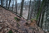
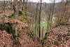
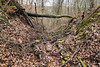
The above images may not be of the site on this page, but were taken nearby. They are loaded from Flickr so please click on them for image credits.
Click here to see more info for this site
Nearby sites
Click here to view sites on an interactive map of the areaKey: Red: member's photo, Blue: 3rd party photo, Yellow: other image, Green: no photo - please go there and take one, Grey: site destroyed
Download sites to:
KML (Google Earth)
GPX (GPS waypoints)
CSV (Garmin/Navman)
CSV (Excel)
To unlock full downloads you need to sign up as a Contributory Member. Otherwise downloads are limited to 50 sites.
Turn off the page maps and other distractions
Nearby sites listing. In the following links * = Image available
1.2km E 101° Mamerlayen Ancient Mine, Quarry or other Industry
1.5km NE 56° Mamerlach Cave or Rock Shelter
3.7km N 358° Beisenerbierg Menhir* Standing Stone (Menhir)
6.6km ESE 115° Blaschette Modern Stone Circle* Modern Stone Circle etc
9.8km E 89° Freylay* Natural Stone / Erratic / Other Natural Feature
10.0km E 89° La Roche des Payens* Rock Art
10.1km E 89° Schleifrillen Häerdcheslee* Polissoir
11.7km NE 42° Rocher Champignon* Polissoir
15.0km ENE 74° Loschbur* Natural Stone / Erratic / Other Natural Feature
15.6km NNE 20° Deiwelselter* Burial Chamber or Dolmen
17.7km ENE 66° De Schwaarze Mann* Rock Art
18.1km ENE 76° Ginstegestell* Ancient Village or Settlement
18.3km ENE 78° Steebaachtal Polissoir* Polissoir
18.9km ENE 65° Keltenhiel* Cave or Rock Shelter
19.6km NE 52° Beaufort Rutschlee* Natural Stone / Erratic / Other Natural Feature
19.7km ENE 64° Schnellert Pseudo-Dolmen* Burial Chamber or Dolmen
22.6km NE 44° Wallendorf Hillfort* Hillfort
23.9km ENE 56° Kalekapp* Cave or Rock Shelter
24.2km NE 48° Wallendorf Voelkerhoehle Cave or Rock Shelter
24.4km SSE 148° Vicus Ricciaco* Ancient Village or Settlement
24.9km ENE 57° Grenzstein im Burghof Bollendorf* Standing Stone (Menhir)
25.3km ENE 60° Dianadenkmal* Rock Art
25.5km E 95° Pierre du Diable (Manternach) Modern Stone Circle etc
25.5km ENE 60° Bollendorf Opferaltar* Natural Stone / Erratic / Other Natural Feature
25.6km SSE 166° Aalburg Befort* Hillfort
View more nearby sites and additional images


 We would like to know more about this location. Please feel free to add a brief description and any relevant information in your own language.
 Wir möchten mehr über diese Stätte erfahren. Bitte zögern Sie nicht, eine kurze Beschreibung und relevante Informationen in Deutsch hinzuzufügen.
 Nous aimerions en savoir encore un peu sur les lieux. S'il vous plaît n'hesitez pas à ajouter une courte description et tous les renseignements pertinents dans votre propre langue.
 Quisieramos informarnos un poco más de las lugares. No dude en añadir una breve descripción y otros datos relevantes en su propio idioma.