

<< Text Pages >> Le Castellet - Cave or Rock Shelter in France in Provence:Bouches-du-Rhône (13)
Submitted by TheCaptain on Wednesday, 08 September 2010 Page Views: 1420
Natural PlacesSite Name: Le CastelletCountry: France
NOTE: This site is 1.614 km away from the location you searched for.
Département: Provence:Bouches-du-Rhône (13) Type: Cave or Rock Shelter
Nearest Village: Cuges-les-Pins
Latitude: 43.268000N Longitude: 5.686000E
Condition:
| 5 | Perfect |
| 4 | Almost Perfect |
| 3 | Reasonable but with some damage |
| 2 | Ruined but still recognisable as an ancient site |
| 1 | Pretty much destroyed, possibly visible as crop marks |
| 0 | No data. |
| -1 | Completely destroyed |
| 5 | Superb |
| 4 | Good |
| 3 | Ordinary |
| 2 | Not Good |
| 1 | Awful |
| 0 | No data. |
| 5 | Can be driven to, probably with disabled access |
| 4 | Short walk on a footpath |
| 3 | Requiring a bit more of a walk |
| 2 | A long walk |
| 1 | In the middle of nowhere, a nightmare to find |
| 0 | No data. |
| 5 | co-ordinates taken by GPS or official recorded co-ordinates |
| 4 | co-ordinates scaled from a detailed map |
| 3 | co-ordinates scaled from a bad map |
| 2 | co-ordinates of the nearest village |
| 1 | co-ordinates of the nearest town |
| 0 | no data |
Be the first person to rate this site - see the 'Contribute!' box in the right hand menu.
Internal Links:
External Links:
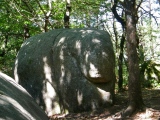
Grotte Sepulcrale in Provence:Bouches-du-Rhône (13)
Le Castellet is a Grotte Sepulcrale in the community of Cuges-les-Pins, Departement of Bouches-du-Rhône, Region of Provence - Alpes - Cote d'Azur
You may be viewing yesterday's version of this page. To see the most up to date information please register for a free account.
Do not use the above information on other web sites or publications without permission of the contributor.
Nearby Images from Flickr

The above images may not be of the site on this page, but were taken nearby. They are loaded from Flickr so please click on them for image credits.
Click here to see more info for this site
Nearby sites
Click here to view sites on an interactive map of the areaKey: Red: member's photo, Blue: 3rd party photo, Yellow: other image, Green: no photo - please go there and take one, Grey: site destroyed
Download sites to:
KML (Google Earth)
GPX (GPS waypoints)
CSV (Garmin/Navman)
CSV (Excel)
To unlock full downloads you need to sign up as a Contributory Member. Otherwise downloads are limited to 50 sites.
Turn off the page maps and other distractions
Nearby sites listing. In the following links * = Image available
5.6km NW 304° Les Platrieres Cave or Rock Shelter
5.6km NW 305° Aven du Plan des Vaches Cave or Rock Shelter
5.6km WNW 304° Vallon de St-Clair Cave or Rock Shelter
5.7km NW 305° Grotte des Racines Cave or Rock Shelter
6.2km N 11° Gros Clappier Tumulus Artificial Mound
7.7km NNE 12° Gendarme Tumulus Artificial Mound
8.8km NNE 21° La Grande Bastide Artificial Mound
9.0km W 271° La Rouviere Cave or Rock Shelter
9.7km SE 133° Le Marechal Grotte Sepulcrale Cave or Rock Shelter
9.7km SE 136° La Clavelle Grotte Sepulcrale Cave or Rock Shelter
10.3km SE 131° Grotte Sepulcrale de la Masc Cave or Rock Shelter
10.5km NE 35° Grotte Sepulcrale des Cedres Cave or Rock Shelter
11.3km NW 318° Abri de Bois de Copiens Cave or Rock Shelter
11.3km NW 317° Baume de Lan Cave or Rock Shelter
11.4km NW 317° Lascours Cave or Rock Shelter
12.1km NNW 340° Grotte des Pebiere Cave or Rock Shelter
12.1km NNW 340° Grotte des Infernets Cave or Rock Shelter
12.1km NNW 339° Grotte des Morts Cave or Rock Shelter
12.3km NE 35° Les Beguines Tumulus Artificial Mound
12.4km SSW 212° Grotte de Terre Vaine Cave or Rock Shelter
13.3km WSW 244° Ellianac Cave or Rock Shelter
13.4km NNE 30° La Creche Grotte Cave or Rock Shelter
13.4km WSW 244° Vallon de Rouviere Cave or Rock Shelter
14.1km NE 34° Tombe du Logis Neuf Burial Chamber or Dolmen
14.5km E 80° Vieux Mounoi Burial Chamber or Dolmen
View more nearby sites and additional images


 We would like to know more about this location. Please feel free to add a brief description and any relevant information in your own language.
 Wir möchten mehr über diese Stätte erfahren. Bitte zögern Sie nicht, eine kurze Beschreibung und relevante Informationen in Deutsch hinzuzufügen.
 Nous aimerions en savoir encore un peu sur les lieux. S'il vous plaît n'hesitez pas à ajouter une courte description et tous les renseignements pertinents dans votre propre langue.
 Quisieramos informarnos un poco más de las lugares. No dude en añadir una breve descripción y otros datos relevantes en su propio idioma.