


<< Our Photo Pages >> Motlandshaugen - Round Barrow(s) in Norway in Rogaland
Submitted by kenntha88 on Tuesday, 13 October 2015 Page Views: 540
Neolithic and Bronze AgeSite Name: MotlandshaugenCountry: Norway
NOTE: This site is 1.22 km away from the location you searched for.
Fylke: Rogaland Type: Round Barrow(s)
Nearest Town: Stavanger Nearest Village: Nærbø
Latitude: 58.657501N Longitude: 5.638422E
Condition:
| 5 | Perfect |
| 4 | Almost Perfect |
| 3 | Reasonable but with some damage |
| 2 | Ruined but still recognisable as an ancient site |
| 1 | Pretty much destroyed, possibly visible as crop marks |
| 0 | No data. |
| -1 | Completely destroyed |
| 5 | Superb |
| 4 | Good |
| 3 | Ordinary |
| 2 | Not Good |
| 1 | Awful |
| 0 | No data. |
| 5 | Can be driven to, probably with disabled access |
| 4 | Short walk on a footpath |
| 3 | Requiring a bit more of a walk |
| 2 | A long walk |
| 1 | In the middle of nowhere, a nightmare to find |
| 0 | No data. |
| 5 | co-ordinates taken by GPS or official recorded co-ordinates |
| 4 | co-ordinates scaled from a detailed map |
| 3 | co-ordinates scaled from a bad map |
| 2 | co-ordinates of the nearest village |
| 1 | co-ordinates of the nearest town |
| 0 | no data |
Internal Links:
External Links:
")
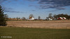
The barrow is 25 metres in diameter and around 2.5 metres in height. It has a huge crater almost destroying the whole middle section and the shape is very distrubed and difficult to see as a round barrow at all.
You may be viewing yesterday's version of this page. To see the most up to date information please register for a free account.
Do not use the above information on other web sites or publications without permission of the contributor.
Nearby Images from Flickr


The above images may not be of the site on this page, but were taken nearby. They are loaded from Flickr so please click on them for image credits.
Click here to see more info for this site
Nearby sites
Click here to view sites on an interactive map of the areaKey: Red: member's photo, Blue: 3rd party photo, Yellow: other image, Green: no photo - please go there and take one, Grey: site destroyed
Download sites to:
KML (Google Earth)
GPX (GPS waypoints)
CSV (Garmin/Navman)
CSV (Excel)
To unlock full downloads you need to sign up as a Contributory Member. Otherwise downloads are limited to 50 sites.
Turn off the page maps and other distractions
Nearby sites listing. In the following links * = Image available
462m SSE 150° Kvia* Round Barrow(s)
788m WSW 244° Hanabergshagen* Ancient Village or Settlement
831m W 266° Klauhauane av Auna-Motland* Ancient Village or Settlement
1.0km WSW 243° Hanabergsrudlå* Cairn
1.8km NNW 334° Nesheimhaugen* Round Barrow(s)
2.7km NW 305° Øvre Vodl* Round Barrow(s)
3.0km WSW 246° Reime* Round Barrow(s)
3.2km NE 50° Malhaugane* Round Barrow(s)
4.0km WSW 250° Obrestad* Barrow Cemetery
5.0km S 191° Varhaug Barrows* Round Barrow(s)
5.2km SSW 198° Kålhaug-Varhaug* Barrow Cemetery
5.3km WNW 282° Hå barrow cemetery* Barrow Cemetery
5.4km S 185° Nyvlestadhaugo* Round Barrow(s)
6.4km S 180° Haugelandshauen* Round Barrow(s)
6.5km S 184° Kolhauen* Round Barrow(s)
6.7km S 181° Bleigjehauen* Round Barrow(s)
6.8km S 186° Finnshaug* Barrow Cemetery
6.9km S 185° Sør-Husvegg* Barrow Cemetery
7.6km N 352° Ramshaug* Round Barrow(s)
7.7km N 356° Trollhaugen* Round Barrow(s)
8.0km ENE 66° Riggjerdet* Ancient Village or Settlement
9.0km NNW 330° Træet* Barrow Cemetery
9.0km NNW 328° Erga-Brautvegen* Round Barrow(s)
9.1km S 177° Stavnheim* Barrow Cemetery
9.1km N 3° Varden* Round Barrow(s)
View more nearby sites and additional images


 We would like to know more about this location. Please feel free to add a brief description and any relevant information in your own language.
 Wir möchten mehr über diese Stätte erfahren. Bitte zögern Sie nicht, eine kurze Beschreibung und relevante Informationen in Deutsch hinzuzufügen.
 Nous aimerions en savoir encore un peu sur les lieux. S'il vous plaît n'hesitez pas à ajouter une courte description et tous les renseignements pertinents dans votre propre langue.
 Quisieramos informarnos un poco más de las lugares. No dude en añadir una breve descripción y otros datos relevantes en su propio idioma.