 with our Megalithic Portal iPhone app")

<< Our Photo Pages >> Lyssand-Smiehaugen - Round Barrow(s) in Norway in Hordaland
Submitted by kenntha88 on Saturday, 08 October 2022 Page Views: 289
Neolithic and Bronze AgeSite Name: Lyssand-SmiehaugenCountry: Norway
NOTE: This site is 16.753 km away from the location you searched for.
Fylke: Hordaland Type: Round Barrow(s)
Nearest Town: Bergen Nearest Village: Osøyro
Latitude: 60.193617N Longitude: 5.486172E
Condition:
| 5 | Perfect |
| 4 | Almost Perfect |
| 3 | Reasonable but with some damage |
| 2 | Ruined but still recognisable as an ancient site |
| 1 | Pretty much destroyed, possibly visible as crop marks |
| 0 | No data. |
| -1 | Completely destroyed |
| 5 | Superb |
| 4 | Good |
| 3 | Ordinary |
| 2 | Not Good |
| 1 | Awful |
| 0 | No data. |
| 5 | Can be driven to, probably with disabled access |
| 4 | Short walk on a footpath |
| 3 | Requiring a bit more of a walk |
| 2 | A long walk |
| 1 | In the middle of nowhere, a nightmare to find |
| 0 | No data. |
| 5 | co-ordinates taken by GPS or official recorded co-ordinates |
| 4 | co-ordinates scaled from a detailed map |
| 3 | co-ordinates scaled from a bad map |
| 2 | co-ordinates of the nearest village |
| 1 | co-ordinates of the nearest town |
| 0 | no data |
Internal Links:
External Links:
")
Smiehaugen barrow is a huge iron age round barrow located partially on a lawn of a local house and partly on a grassy meadow. The barrow is easily visible since it is only covered in short grass. Parts of the barrow have been dug out in later years, giving the barrow almost a "step" appearance since 1/3 of the top have been removed.
The Smiehaugen barrow is 40 metres in diameter and around 4 metres in height.
Just south of the smiehaugen barrow is another round barrow around 20 metres in diameter and 2 metres in height. This barrow has been damaged by a garage buildt partly into the barrow and it is also overgrown with large trees.
You may be viewing yesterday's version of this page. To see the most up to date information please register for a free account.
")
")
")
")
Do not use the above information on other web sites or publications without permission of the contributor.
Nearby Images from Flickr
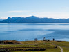


The above images may not be of the site on this page, but were taken nearby. They are loaded from Flickr so please click on them for image credits.
Click here to see more info for this site
Nearby sites
Click here to view sites on an interactive map of the areaKey: Red: member's photo, Blue: 3rd party photo, Yellow: other image, Green: no photo - please go there and take one, Grey: site destroyed
Download sites to:
KML (Google Earth)
GPX (GPS waypoints)
CSV (Garmin/Navman)
CSV (Excel)
To unlock full downloads you need to sign up as a Contributory Member. Otherwise downloads are limited to 50 sites.
Turn off the page maps and other distractions
Nearby sites listing. In the following links * = Image available
329m SSW 192° Hatvikvegen-Kongshaugen* Standing Stone (Menhir)
627m SSE 168° Solstrand Garden* Cairn
3.4km W 276° Ulven standing stone* Standing Stone (Menhir)
4.3km WSW 236° Skipalehaugen* Round Barrow(s)
4.9km SW 214° Tennhaugen-Kongahaugen* Round Barrow(s)
6.6km ESE 124° Hansahaugen* Round Barrow(s)
7.1km SE 130° Vinnes Standing Stone* Standing Stone (Menhir)
7.3km SE 128° Mattisbrekka* Rock Art
7.4km SE 130° Stølarøyso* Cairn
7.5km SE 126° Vollena-Stengsland* Cist
7.5km ESE 124° Varmeholo* Rock Art
7.5km SE 124° Steingsland* Cist
7.6km SE 130° Revhaugen Hordaland* Cairn
12.3km NW 315° Munkevollen* Stone Circle
14.3km NW 320° Grimseidvegen Standing Stone* Standing Stone (Menhir)
15.6km S 176° Spansteigen Standing Stone* Standing Stone (Menhir)
16.1km S 170° Todneset* Cairn
25.3km SE 146° Hamarhaug* Rock Art
25.4km SSE 154° Årbakkavollen cemetery* Barrow Cemetery
32.6km SSW 197° Rimsvarden* Cairn
35.4km NNW 335° Kongshaugen Mound* Round Barrow(s)
36.7km SE 128° Modern Menhir at Kvinnherad Church* Modern Stone Circle etc
37.2km E 81° Vikingnes* Cairn
39.3km ENE 73° Augastad standing stone* Standing Stone (Menhir)
41.4km ENE 61° Grova* Round Barrow(s)
View more nearby sites and additional images


 We would like to know more about this location. Please feel free to add a brief description and any relevant information in your own language.
 Wir möchten mehr über diese Stätte erfahren. Bitte zögern Sie nicht, eine kurze Beschreibung und relevante Informationen in Deutsch hinzuzufügen.
 Nous aimerions en savoir encore un peu sur les lieux. S'il vous plaît n'hesitez pas à ajouter une courte description et tous les renseignements pertinents dans votre propre langue.
 Quisieramos informarnos un poco más de las lugares. No dude en añadir una breve descripción y otros datos relevantes en su propio idioma.