


<< Our Photo Pages >> Bøvika standing stones - Standing Stone (Menhir) in Norway in Rogaland
Submitted by kenntha88 on Monday, 22 October 2012 Page Views: 2714
Neolithic and Bronze AgeSite Name: Bøvika standing stones Alternative Name: Ytre BøCountry: Norway
NOTE: This site is 2.512 km away from the location you searched for.
Fylke: Rogaland Type: Standing Stone (Menhir)
Nearest Town: Stavanger Nearest Village: Randaberg
Latitude: 59.014267N Longitude: 5.578265E
Condition:
| 5 | Perfect |
| 4 | Almost Perfect |
| 3 | Reasonable but with some damage |
| 2 | Ruined but still recognisable as an ancient site |
| 1 | Pretty much destroyed, possibly visible as crop marks |
| 0 | No data. |
| -1 | Completely destroyed |
| 5 | Superb |
| 4 | Good |
| 3 | Ordinary |
| 2 | Not Good |
| 1 | Awful |
| 0 | No data. |
| 5 | Can be driven to, probably with disabled access |
| 4 | Short walk on a footpath |
| 3 | Requiring a bit more of a walk |
| 2 | A long walk |
| 1 | In the middle of nowhere, a nightmare to find |
| 0 | No data. |
| 5 | co-ordinates taken by GPS or official recorded co-ordinates |
| 4 | co-ordinates scaled from a detailed map |
| 3 | co-ordinates scaled from a bad map |
| 2 | co-ordinates of the nearest village |
| 1 | co-ordinates of the nearest town |
| 0 | no data |
Internal Links:
External Links:
")
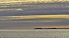
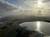
The area around is a grassy open field with a nice view over the sea. The stone itself is around 6.5 metres in height, almost 7 metres in height! It is around 30 cm wide at the widest and it has a beautiful smooth surface. Some smaller trees are growing around the base. It is tilting just a little to one side. I was really impressed by seeing this stone! The stone is visible from miles away.
You may be viewing yesterday's version of this page. To see the most up to date information please register for a free account.
")
")
")
Do not use the above information on other web sites or publications without permission of the contributor.
Nearby Images from Flickr

The above images may not be of the site on this page, but were taken nearby. They are loaded from Flickr so please click on them for image credits.
Click here to see more info for this site
Nearby sites
Click here to view sites on an interactive map of the areaKey: Red: member's photo, Blue: 3rd party photo, Yellow: other image, Green: no photo - please go there and take one, Grey: site destroyed
Download sites to:
KML (Google Earth)
GPX (GPS waypoints)
CSV (Garmin/Navman)
CSV (Excel)
To unlock full downloads you need to sign up as a Contributory Member. Otherwise downloads are limited to 50 sites.
Turn off the page maps and other distractions
Nearby sites listing. In the following links * = Image available
75m SE 139° Ytre Bø Runestone* Carving
590m WSW 238° Løndshaug* Cairn
874m SSW 194° Børudlo* Cairn
2.4km ESE 101° Harastad* Rock Art
2.4km SSW 192° Grøderøysa* Chambered Tomb
3.3km SSE 162° Vistehola* Cave or Rock Shelter
3.8km SE 138° Vestre Goa standing stones* Standing Stones
5.1km SE 136° Hålandshaugen* Standing Stone (Menhir)
6.1km NE 48° Sokn Standing Stone* Standing Stone (Menhir)
6.4km SSE 159° Aubeberget* Rock Art
6.7km SSE 165° Jåsund Barrow* Round Barrow(s)
6.8km S 172° Sothaug* Round Barrow(s)
6.9km SSE 158° Pallesen-Tomta* Standing Stones
7.0km SSE 150° Mimmarudla* Round Barrow(s)
7.1km ENE 66° Hegreberg* Standing Stone (Menhir)
7.1km ENE 66° Hegrebergveien Pigghedlane* Standing Stones
7.2km ENE 69° Varaberg* Standing Stone (Menhir)
7.6km NNE 27° Hodnafjell* Standing Stone (Menhir)
8.1km SSE 156° Fluberget* Rock Art
8.2km SSE 167° Meling Standing Stone* Standing Stone (Menhir)
8.3km NE 50° Askje Hedlehaug* Standing Stone (Menhir)
8.5km ESE 102° Stavangerfjords Vei* Standing Stone (Menhir)
8.9km NE 38° Vaula Settlement* Ancient Village or Settlement
9.0km NNE 30° Mosterøyvegen Standing Stone* Standing Stone (Menhir)
9.1km NE 42° Hedlehaugen* Standing Stones
View more nearby sites and additional images


 We would like to know more about this location. Please feel free to add a brief description and any relevant information in your own language.
 Wir möchten mehr über diese Stätte erfahren. Bitte zögern Sie nicht, eine kurze Beschreibung und relevante Informationen in Deutsch hinzuzufügen.
 Nous aimerions en savoir encore un peu sur les lieux. S'il vous plaît n'hesitez pas à ajouter une courte description et tous les renseignements pertinents dans votre propre langue.
 Quisieramos informarnos un poco más de las lugares. No dude en añadir una breve descripción y otros datos relevantes en su propio idioma.