

<< Our Photo Pages >> Tumulus de Xhendremael - Round Barrow(s) in Belgium in Liège
Submitted by johnstone on Monday, 11 May 2020 Page Views: 530
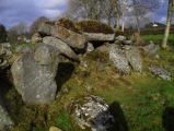
Iron Age and Later PrehistorySite Name: Tumulus de XhendremaelCountry: Belgium
NOTE: This site is 2.731 km away from the location you searched for.
Province: Liège Type: Round Barrow(s)
Nearest Town: Liège Nearest Village: Xhendremael
Latitude: 50.697353N Longitude: 5.478119E
Condition:
| 5 | Perfect |
| 4 | Almost Perfect |
| 3 | Reasonable but with some damage |
| 2 | Ruined but still recognisable as an ancient site |
| 1 | Pretty much destroyed, possibly visible as crop marks |
| 0 | No data. |
| -1 | Completely destroyed |
| 5 | Superb |
| 4 | Good |
| 3 | Ordinary |
| 2 | Not Good |
| 1 | Awful |
| 0 | No data. |
| 5 | Can be driven to, probably with disabled access |
| 4 | Short walk on a footpath |
| 3 | Requiring a bit more of a walk |
| 2 | A long walk |
| 1 | In the middle of nowhere, a nightmare to find |
| 0 | No data. |
| 5 | co-ordinates taken by GPS or official recorded co-ordinates |
| 4 | co-ordinates scaled from a detailed map |
| 3 | co-ordinates scaled from a bad map |
| 2 | co-ordinates of the nearest village |
| 1 | co-ordinates of the nearest town |
| 0 | no data |
Internal Links:
External Links:
I have visited· I would like to visit
johnstone visited on 30th Jun 1998 - their rating: Cond: 4 Amb: 3 Access: 3
")
Gallo-Roman round barrow in the community of Ans, along the Rue Tasson.
More info:
Wikipedia
You may be viewing yesterday's version of this page. To see the most up to date information please register for a free account.
Do not use the above information on other web sites or publications without permission of the contributor.
Nearby Images from Flickr


The above images may not be of the site on this page, but were taken nearby. They are loaded from Flickr so please click on them for image credits.
Click here to see more info for this site
Nearby sites
Click here to view sites on an interactive map of the areaKey: Red: member's photo, Blue: 3rd party photo, Yellow: other image, Green: no photo - please go there and take one, Grey: site destroyed
Download sites to:
KML (Google Earth)
GPX (GPS waypoints)
CSV (Garmin/Navman)
CSV (Excel)
To unlock full downloads you need to sign up as a Contributory Member. Otherwise downloads are limited to 50 sites.
Turn off the page maps and other distractions
Nearby sites listing. In the following links * = Image available
2.5km SW 225° Grosse Pierre (Hognoul)* Natural Stone / Erratic / Other Natural Feature
5.2km NW 304° Herstappe Tumulus* Barrow Cemetery
7.6km WSW 244° Tumulus de Noville* Round Barrow(s)
8.0km W 272° Tumulus de Hodeige* Round Barrow(s)
8.8km SE 131° Archéoforum de Liège* Museum
8.9km NNW 349° Romeinse Muur, Tongeren* Vitrified Fort
9.3km N 354° Tongeren standbeeld van Ambiorix* Modern Stone Circle etc
9.4km N 355° Gallo-Romeins Museum* Museum
12.7km SSW 203° Grottes Schmerling* Cave or Rock Shelter
13.6km SSW 196° Prehistomuseum* Museum
16.9km SSE 166° Carrefour de la Croix d'Or* Stone Circle
17.0km SE 129° Dolmen du Diable* Burial Chamber or Dolmen
17.2km SW 219° Musée du Château de Jehay* Museum
17.4km SW 219° Menhir du Grand Bois* Standing Stone (Menhir)
18.4km S 170° Fine Pierre de Plainevaux* Rock Outcrop
21.2km ENE 57° Informatiecentrum Mijn Rijckholt Museum
21.6km ENE 60° Rijckholt Flint Mine* Ancient Mine, Quarry or other Industry
22.1km NE 42° Stenen van Sint-Pietersberg* Stone Circle
23.6km S 187° Borne seigneurale de Houchenée* Marker Stone
24.3km NNW 347° Kruisveldstraat* Stone Circle
26.2km S 187° Grosse Pierre d'Ellemelle* Standing Stone (Menhir)
27.4km NNW 340° Atheneum van Hasselt* Modern Stone Circle etc
27.6km N 3° Duivelstenen van Langerlo* Standing Stones
28.0km NNW 339° Hendrik Van Veldeke statue* Modern Stone Circle etc
28.3km SE 139° Menhir de Deigné* Standing Stone (Menhir)
View more nearby sites and additional images


 We would like to know more about this location. Please feel free to add a brief description and any relevant information in your own language.
 Wir möchten mehr über diese Stätte erfahren. Bitte zögern Sie nicht, eine kurze Beschreibung und relevante Informationen in Deutsch hinzuzufügen.
 Nous aimerions en savoir encore un peu sur les lieux. S'il vous plaît n'hesitez pas à ajouter une courte description et tous les renseignements pertinents dans votre propre langue.
 Quisieramos informarnos un poco más de las lugares. No dude en añadir una breve descripción y otros datos relevantes en su propio idioma.