


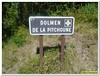
<< Our Photo Pages >> Dolmen de la Pitchoune - Burial Chamber or Dolmen in France in Provence:Vaucluse (84)
Submitted by thecaptain on Monday, 21 July 2008 Page Views: 7514
Neolithic and Bronze AgeSite Name: Dolmen de la Pitchoune Alternative Name: Dolmen de la PichoneCountry: France
NOTE: This site is 3.436 km away from the location you searched for.
Département: Provence:Vaucluse (84) Type: Burial Chamber or Dolmen
Nearest Town: Cavaillon Nearest Village: Ménerbes
Latitude: 43.826784N Longitude: 5.229107E
Condition:
| 5 | Perfect |
| 4 | Almost Perfect |
| 3 | Reasonable but with some damage |
| 2 | Ruined but still recognisable as an ancient site |
| 1 | Pretty much destroyed, possibly visible as crop marks |
| 0 | No data. |
| -1 | Completely destroyed |
| 5 | Superb |
| 4 | Good |
| 3 | Ordinary |
| 2 | Not Good |
| 1 | Awful |
| 0 | No data. |
| 5 | Can be driven to, probably with disabled access |
| 4 | Short walk on a footpath |
| 3 | Requiring a bit more of a walk |
| 2 | A long walk |
| 1 | In the middle of nowhere, a nightmare to find |
| 0 | No data. |
| 5 | co-ordinates taken by GPS or official recorded co-ordinates |
| 4 | co-ordinates scaled from a detailed map |
| 3 | co-ordinates scaled from a bad map |
| 2 | co-ordinates of the nearest village |
| 1 | co-ordinates of the nearest town |
| 0 | no data |
Internal Links:
External Links:
I have visited· I would like to visit
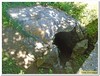
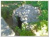
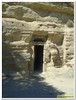
TheCaptain visited on 23rd Sep 2005 - their rating: Cond: 3 Amb: 3 Access: 5 A few kilometres to the east of Ménerbes, along the D.103, and to the west of Lacost, the home of the chateau of the Marquis de Sade, can be found this dolmen which has its own signpost. It is right beside the road and below ground level, below an arched bridge type structure of the road.
The dolmen is now sort of built into the terraced hillside, but whether it was originally, or just that the local land has risen - perhaps due to the hillside falling down - I do not know. The 4m by 3m chamber has a large backstone and two portal entry stones, but the sides are of vaulted drystone construction. It is tall enough to stand up inside the chamber below the single large capstone, the back of which is now within the hillside. Whether the whole thing was cut into the ground, or originally built above ground level with a cairn of stones I cannot tell. I assume it was above ground, but the level of soil around it has risen. The chamber looks to have remains of an entry passageway, which would open to the southwest, at about 235°, looking across the valley and up into the Luberon Hills.
The dolmen has at times been used as a storage shed, and with the road right besides, and the terraced land behind, I wouldn't be surprised if it has been much altered. I assume the bridge bit of the road has been built here to protect the dolmen by arching over the top.
")
It is right beside the road and below ground level, below an arched bridge type structure of the road. The dolmen is now sort of built into the terraced hillside, but whether it was originally, or just that the local land has risen - perhaps due to the hillside falling down - I do not know.
The 4m by 3m chamber has a large backstone and two portal entry stones, but the sides are of vaulted drystone construction. It is tall enough to stand up inside the chamber below the single large capstone, the back of which is now within the hillside. Whether the whole thing was cut into the ground, or originally built abouve ground level with a cairn of stones I cannot tell. I assume it was above ground, but the level of soil around it has risen.
The chamber looks to have remains of an entry passageway, which would open to the southwest, at about 235°, looking across the valley and up into the Luberon Hills.
The dolmen has at times been used as a storage shed, and with the road right besides, and the terraced land behind, I wouldnt be surprised if it has been much altered. I assume the bridge bit of the road has been built here to protect the dolmen by arching over the top.
You may be viewing yesterday's version of this page. To see the most up to date information please register for a free account.
")
")
")
")
Do not use the above information on other web sites or publications without permission of the contributor.
Nearby Images from Flickr
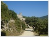
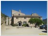
The above images may not be of the site on this page, but were taken nearby. They are loaded from Flickr so please click on them for image credits.
Click here to see more info for this site
Nearby sites
Click here to view sites on an interactive map of the areaKey: Red: member's photo, Blue: 3rd party photo, Yellow: other image, Green: no photo - please go there and take one, Grey: site destroyed
Download sites to:
KML (Google Earth)
GPX (GPS waypoints)
CSV (Garmin/Navman)
CSV (Excel)
To unlock full downloads you need to sign up as a Contributory Member. Otherwise downloads are limited to 50 sites.
Turn off the page maps and other distractions
Nearby sites listing. In the following links * = Image available
4.2km NNE 17° Trabari Cave or Rock Shelter
4.2km NNE 18° L'Ubac Burial Chamber or Dolmen
6.3km E 94° Saint Gervais Cave or Rock Shelter
9.4km WNW 282° Fontblanco Cave or Rock Shelter
9.4km WNW 282° Jas de Juvert Cave or Rock Shelter
9.5km NW 318° Vallon Carbonel Burial Chamber or Dolmen
10.9km W 274° Sainte-Guimelle Cave or Rock Shelter
11.2km SE 143° Les Vachons (Lauris) Cave or Rock Shelter
11.7km NW 309° Les Esclargades Cave or Rock Shelter
12.0km E 88° Grotte Julian Cave or Rock Shelter
12.8km NW 323° Fontaine de Vaucluse* Holy Well or Sacred Spring
13.6km WSW 258° Baume des Enfers Cave or Rock Shelter
13.6km WSW 258° Trou Puceu Cave or Rock Shelter
13.7km WSW 258° Grotte Basse de Vidauque Cave or Rock Shelter
13.7km WSW 258° Les Dentales Cave or Rock Shelter
15.3km SSW 197° Oppidum St Jean de Vernègues* Ancient Village or Settlement
15.8km WSW 256° La Roque Fauconniere Cave or Rock Shelter
15.9km WSW 256° Mas des Gavots Burial Chamber or Dolmen
18.0km NE 44° Sanguinouse Cave or Rock Shelter
19.5km NNW 330° Jas de Juvert Cave or Rock Shelter
19.8km NNW 341° Les Dents Cave or Rock Shelter
19.8km NNW 341° Grotte du Stade Cave or Rock Shelter
19.9km NNW 341° Souveilles Cave or Rock Shelter
20.6km SE 140° Le Moulestre Cave or Rock Shelter
20.6km SE 139° St-Valentin Cave or Rock Shelter
View more nearby sites and additional images


 We would like to know more about this location. Please feel free to add a brief description and any relevant information in your own language.
 Wir möchten mehr über diese Stätte erfahren. Bitte zögern Sie nicht, eine kurze Beschreibung und relevante Informationen in Deutsch hinzuzufügen.
 Nous aimerions en savoir encore un peu sur les lieux. S'il vous plaît n'hesitez pas à ajouter une courte description et tous les renseignements pertinents dans votre propre langue.
 Quisieramos informarnos un poco más de las lugares. No dude en añadir una breve descripción y otros datos relevantes en su propio idioma.