


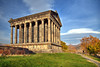
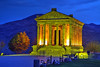
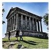
<< Our Photo Pages >> Garni temple - Ancient Temple in Armenia
Submitted by KaiHofmann on Thursday, 01 April 2010 Page Views: 6342
Multi-periodSite Name: Garni templeCountry: Armenia Type: Ancient Temple
Nearest Town: Yerewan Nearest Village: Garni
Latitude: 40.112440N Longitude: 44.729936E
Condition:
| 5 | Perfect |
| 4 | Almost Perfect |
| 3 | Reasonable but with some damage |
| 2 | Ruined but still recognisable as an ancient site |
| 1 | Pretty much destroyed, possibly visible as crop marks |
| 0 | No data. |
| -1 | Completely destroyed |
| 5 | Superb |
| 4 | Good |
| 3 | Ordinary |
| 2 | Not Good |
| 1 | Awful |
| 0 | No data. |
| 5 | Can be driven to, probably with disabled access |
| 4 | Short walk on a footpath |
| 3 | Requiring a bit more of a walk |
| 2 | A long walk |
| 1 | In the middle of nowhere, a nightmare to find |
| 0 | No data. |
| 5 | co-ordinates taken by GPS or official recorded co-ordinates |
| 4 | co-ordinates scaled from a detailed map |
| 3 | co-ordinates scaled from a bad map |
| 2 | co-ordinates of the nearest village |
| 1 | co-ordinates of the nearest town |
| 0 | no data |
Internal Links:
External Links:
I have visited· I would like to visit
DrewParsons would like to visit
")
An old Hellenistic Sun Temple in front of a deep valley. Nearby an ancient Armenian palace and a standing stone with cuneiform inscriptions. The famous Geghard Monastery with old caves, cross stones and a sacred spring inside the church, is some 6 kilometres away.
You may be viewing yesterday's version of this page. To see the most up to date information please register for a free account.
")
Do not use the above information on other web sites or publications without permission of the contributor.
Nearby Images from Flickr


The above images may not be of the site on this page, but were taken nearby. They are loaded from Flickr so please click on them for image credits.
Click here to see more info for this site
Nearby sites
Click here to view sites on an interactive map of the areaKey: Red: member's photo, Blue: 3rd party photo, Yellow: other image, Green: no photo - please go there and take one, Grey: site destroyed
Download sites to:
KML (Google Earth)
GPX (GPS waypoints)
CSV (Garmin/Navman)
CSV (Excel)
To unlock full downloads you need to sign up as a Contributory Member. Otherwise downloads are limited to 50 sites.
Turn off the page maps and other distractions
Nearby sites listing. In the following links * = Image available
8.1km ENE 67° Geghard monastery* Ancient Cross
9.1km NW 314° Voghjaberd Caves Cave or Rock Shelter
16.3km NE 52° Geghard Petroglyphs Rock Art
16.4km NNW 339° Aramus Ancient Village or Settlement
16.6km W 281° Erebuni Ancient Village or Settlement
18.2km NE 44° Geghard Petroglyphs 2 Rock Art
22.1km WNW 283° Shengavit Ancient Village or Settlement
22.2km NW 307° Karmir Berd Rock Art
24.0km W 281° Karmir Blur Ancient Village or Settlement
29.1km SSW 207° Khor Virap* Early Christian Sculptured Stone
29.3km SSW 208° Artashat Ancient Village or Settlement
39.4km ESE 105° Bullhead Vishap Standing Stone (Menhir)
40.8km WNW 293° Voskevaz Vishap Standing Stone (Menhir)
43.4km WNW 296° Agarak 2 Ancient Village or Settlement
43.4km WNW 298° Agarak Rock Cut Tomb
44.5km WNW 295° Voskehat settlement Ancient Village or Settlement
45.6km ENE 66° K'anaker* Stone Circle
46.1km W 272° Metsamor Complex* Standing Stones
46.7km ESE 113° Selim Caravansarai* Ancient Trackway
47.8km NNE 22° Lchashen Bronze-Age complex Ancient Village or Settlement
49.2km NE 41° Berdunk Urartian Fortress Promontory Fort / Cliff Castle
56.8km WNW 288° Shamiram settlement Ancient Village or Settlement
58.6km SE 136° Areni-1 Cave* Cave or Rock Shelter
63.0km WNW 295° Kakavadzor temple Ancient Temple
64.7km SSE 153° Ovchular Tepe Ancient Village or Settlement
View more nearby sites and additional images


 We would like to know more about this location. Please feel free to add a brief description and any relevant information in your own language.
 Wir möchten mehr über diese Stätte erfahren. Bitte zögern Sie nicht, eine kurze Beschreibung und relevante Informationen in Deutsch hinzuzufügen.
 Nous aimerions en savoir encore un peu sur les lieux. S'il vous plaît n'hesitez pas à ajouter une courte description et tous les renseignements pertinents dans votre propre langue.
 Quisieramos informarnos un poco más de las lugares. No dude en añadir una breve descripción y otros datos relevantes en su propio idioma.