 with our Megalithic Portal iPhone app")


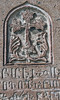
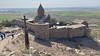
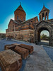
<< Our Photo Pages >> Khor Virap - Early Christian Sculptured Stone in Armenia
Submitted by KaiHofmann on Tuesday, 29 March 2011 Page Views: 4796
Early Medieval (Dark Age)Site Name: Khor VirapCountry: Armenia
NOTE: This site is 22.779 km away from the location you searched for.
Type: Early Christian Sculptured Stone
Nearest Town: Ararat Nearest Village: Lusarat
Latitude: 39.878316N Longitude: 44.576371E
Condition:
| 5 | Perfect |
| 4 | Almost Perfect |
| 3 | Reasonable but with some damage |
| 2 | Ruined but still recognisable as an ancient site |
| 1 | Pretty much destroyed, possibly visible as crop marks |
| 0 | No data. |
| -1 | Completely destroyed |
| 5 | Superb |
| 4 | Good |
| 3 | Ordinary |
| 2 | Not Good |
| 1 | Awful |
| 0 | No data. |
| 5 | Can be driven to, probably with disabled access |
| 4 | Short walk on a footpath |
| 3 | Requiring a bit more of a walk |
| 2 | A long walk |
| 1 | In the middle of nowhere, a nightmare to find |
| 0 | No data. |
| 5 | co-ordinates taken by GPS or official recorded co-ordinates |
| 4 | co-ordinates scaled from a detailed map |
| 3 | co-ordinates scaled from a bad map |
| 2 | co-ordinates of the nearest village |
| 1 | co-ordinates of the nearest town |
| 0 | no data |
Internal Links:
External Links:
")
Early Christian monastery, with an amazing view to mount Ararat.
You may be viewing yesterday's version of this page. To see the most up to date information please register for a free account.
")
")
Do not use the above information on other web sites or publications without permission of the contributor.
Nearby Images from Flickr
The above images may not be of the site on this page, but were taken nearby. They are loaded from Flickr so please click on them for image credits.
Click here to see more info for this site
Nearby sites
Click here to view sites on an interactive map of the areaKey: Red: member's photo, Blue: 3rd party photo, Yellow: other image, Green: no photo - please go there and take one, Grey: site destroyed
Download sites to:
KML (Google Earth)
GPX (GPS waypoints)
CSV (Garmin/Navman)
CSV (Excel)
To unlock full downloads you need to sign up as a Contributory Member. Otherwise downloads are limited to 50 sites.
Turn off the page maps and other distractions
Nearby sites listing. In the following links * = Image available
696m WNW 284° Artashat Ancient Village or Settlement
29.1km NNE 27° Garni temple* Ancient Temple
29.3km N 354° Erebuni Ancient Village or Settlement
32.1km NNW 345° Shengavit Ancient Village or Settlement
32.3km NNW 341° Karmir Blur Ancient Village or Settlement
33.0km NNE 11° Voghjaberd Caves Cave or Rock Shelter
35.7km NE 35° Geghard monastery* Ancient Cross
39.6km N 353° Karmir Berd Rock Art
41.9km N 10° Aramus Ancient Village or Settlement
43.0km NW 310° Metsamor Complex* Standing Stones
44.4km NE 36° Geghard Petroglyphs Rock Art
46.8km NNE 33° Geghard Petroglyphs 2 Rock Art
48.7km NNW 330° Voskevaz Vishap Standing Stone (Menhir)
52.1km NNW 330° Agarak 2 Ancient Village or Settlement
52.3km NNW 328° Voskehat settlement Ancient Village or Settlement
52.7km SE 127° Ovchular Tepe Ancient Village or Settlement
52.9km NNW 331° Agarak Rock Cut Tomb
53.7km ENE 72° Bullhead Vishap Standing Stone (Menhir)
56.1km ESE 107° Areni-1 Cave* Cave or Rock Shelter
56.8km E 82° Selim Caravansarai* Ancient Trackway
60.0km NW 317° Shamiram settlement Ancient Village or Settlement
68.7km NW 320° Kakavadzor temple Ancient Temple
70.5km NE 51° K'anaker* Stone Circle
71.1km E 99° Tanahati* Early Christian Sculptured Stone
76.8km NNE 24° Lchashen Bronze-Age complex Ancient Village or Settlement
View more nearby sites and additional images


 We would like to know more about this location. Please feel free to add a brief description and any relevant information in your own language.
 Wir möchten mehr über diese Stätte erfahren. Bitte zögern Sie nicht, eine kurze Beschreibung und relevante Informationen in Deutsch hinzuzufügen.
 Nous aimerions en savoir encore un peu sur les lieux. S'il vous plaît n'hesitez pas à ajouter une courte description et tous les renseignements pertinents dans votre propre langue.
 Quisieramos informarnos un poco más de las lugares. No dude en añadir una breve descripción y otros datos relevantes en su propio idioma.