


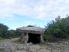
<< Text Pages >> Dolmen des Geantes 1 - Burial Chamber or Dolmen in France in Rhone:Ardèche (07)
Submitted by TheCaptain on Friday, 06 May 2011 Page Views: 1450
Neolithic and Bronze AgeSite Name: Dolmen des Geantes 1 Alternative Name: La Tour, Geantes, Dolmen des Joyandes (A)Country: France
NOTE: This site is 9.069 km away from the location you searched for.
Département: Rhone:Ardèche (07) Type: Burial Chamber or Dolmen
Nearest Town: Montelimar Nearest Village: Bourg-St-Andeol
Latitude: 44.364061N Longitude: 4.584054E
Condition:
| 5 | Perfect |
| 4 | Almost Perfect |
| 3 | Reasonable but with some damage |
| 2 | Ruined but still recognisable as an ancient site |
| 1 | Pretty much destroyed, possibly visible as crop marks |
| 0 | No data. |
| -1 | Completely destroyed |
| 5 | Superb |
| 4 | Good |
| 3 | Ordinary |
| 2 | Not Good |
| 1 | Awful |
| 0 | No data. |
| 5 | Can be driven to, probably with disabled access |
| 4 | Short walk on a footpath |
| 3 | Requiring a bit more of a walk |
| 2 | A long walk |
| 1 | In the middle of nowhere, a nightmare to find |
| 0 | No data. |
| 5 | co-ordinates taken by GPS or official recorded co-ordinates |
| 4 | co-ordinates scaled from a detailed map |
| 3 | co-ordinates scaled from a bad map |
| 2 | co-ordinates of the nearest village |
| 1 | co-ordinates of the nearest town |
| 0 | no data |
Be the first person to rate this site - see the 'Contribute!' box in the right hand menu.
Internal Links:
External Links:
burial chamber in Rhone-Alpes:Ardeche
Dolmen des Geantes 1 is a burial chamber in the community of Bourg-St-Andeol, Departement of Ardeche, Region of Rhone-Alpes
You may be viewing yesterday's version of this page. To see the most up to date information please register for a free account.
Do not use the above information on other web sites or publications without permission of the contributor.
Nearby Images from Flickr
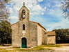

The above images may not be of the site on this page, but were taken nearby. They are loaded from Flickr so please click on them for image credits.
Click here to see more info for this site
Nearby sites
Click here to view sites on an interactive map of the areaKey: Red: member's photo, Blue: 3rd party photo, Yellow: other image, Green: no photo - please go there and take one, Grey: site destroyed
Download sites to:
KML (Google Earth)
GPX (GPS waypoints)
CSV (Garmin/Navman)
CSV (Excel)
To unlock full downloads you need to sign up as a Contributory Member. Otherwise downloads are limited to 50 sites.
Turn off the page maps and other distractions
Nearby sites listing. In the following links * = Image available
504m NNW 334° Dolmen des Geantes 6 Burial Chamber or Dolmen
679m NW 322° Dolmen des Geantes 2 Burial Chamber or Dolmen
694m NNW 327° Dolmen des Geantes 5 Burial Chamber or Dolmen
749m NW 321° Dolmen des Geantes 3 Burial Chamber or Dolmen
842m NNW 329° Dolmen des Geantes 4 Burial Chamber or Dolmen
1.8km SW 217° Pradeches Dolmen* Burial Chamber or Dolmen
1.9km SW 217° Cromlech du Pradinas Stone Circle
2.3km W 270° Menhir du Champ Vermeil Standing Stone (Menhir)
2.4km W 266° Champ Vermeil Dolmen* Burial Chamber or Dolmen
2.9km WSW 252° Dolmen de la Close Burial Chamber or Dolmen
3.7km NW 313° Dolmen du Grand Paty 1 Burial Chamber or Dolmen
4.0km NW 310° Dolmen du Grand Paty 3 Burial Chamber or Dolmen
4.1km NW 308° Dolmen du Grand Paty 2 Burial Chamber or Dolmen
4.4km SW 222° Grosse Pierre Menhir* Standing Stone (Menhir)
4.7km SW 222° Colombier Dolmen* Burial Chamber or Dolmen
4.8km WSW 237° Dolmen du Pouzat Burial Chamber or Dolmen
4.9km W 265° Dolmen du Cloget Burial Chamber or Dolmen
5.0km SW 216° Grotte de la Tête du Lion* Cave or Rock Shelter
5.3km SW 219° Grotte de Saint-Marcel* Cave or Rock Shelter
5.4km WNW 296° Beauregard Burial Chamber or Dolmen
5.6km SSW 211° Statue-menhir de l'Aven Meunier* Sculptured Stone
5.7km SW 214° Grotte Chabot Cave or Rock Shelter
5.7km SW 217° Grotte aux points Cave or Rock Shelter
5.8km W 276° Aven Marzal Dolmen* Burial Chamber or Dolmen
5.8km SSW 209° Grotte dite des Deux Ouvertures Cave or Rock Shelter
View more nearby sites and additional images


 We would like to know more about this location. Please feel free to add a brief description and any relevant information in your own language.
 Wir möchten mehr über diese Stätte erfahren. Bitte zögern Sie nicht, eine kurze Beschreibung und relevante Informationen in Deutsch hinzuzufügen.
 Nous aimerions en savoir encore un peu sur les lieux. S'il vous plaît n'hesitez pas à ajouter une courte description et tous les renseignements pertinents dans votre propre langue.
 Quisieramos informarnos un poco más de las lugares. No dude en añadir una breve descripción y otros datos relevantes en su propio idioma.