


<< Our Photo Pages >> Llucassaldent - Broch or Nuraghe in Spain in Balearic Isles (Menorca / Minorca)
Submitted by SolarMegalith on Saturday, 08 February 2020 Page Views: 411
Neolithic and Bronze AgeSite Name: LlucassaldentCountry: Spain
NOTE: This site is 2.927 km away from the location you searched for.
Region: Balearic Isles (Menorca / Minorca) Type: Broch or Nuraghe
Latitude: 39.918732N Longitude: 4.112215E
Condition:
| 5 | Perfect |
| 4 | Almost Perfect |
| 3 | Reasonable but with some damage |
| 2 | Ruined but still recognisable as an ancient site |
| 1 | Pretty much destroyed, possibly visible as crop marks |
| 0 | No data. |
| -1 | Completely destroyed |
| 5 | Superb |
| 4 | Good |
| 3 | Ordinary |
| 2 | Not Good |
| 1 | Awful |
| 0 | No data. |
| 5 | Can be driven to, probably with disabled access |
| 4 | Short walk on a footpath |
| 3 | Requiring a bit more of a walk |
| 2 | A long walk |
| 1 | In the middle of nowhere, a nightmare to find |
| 0 | No data. |
| 5 | co-ordinates taken by GPS or official recorded co-ordinates |
| 4 | co-ordinates scaled from a detailed map |
| 3 | co-ordinates scaled from a bad map |
| 2 | co-ordinates of the nearest village |
| 1 | co-ordinates of the nearest town |
| 0 | no data |
Internal Links:
External Links:
I have visited· I would like to visit
SolarMegalith visited on 16th Apr 2015 - their rating: Cond: 2 Amb: 4 Access: 4
")
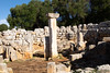
Heavily overgrown remains of a talayot preserved as a mound of debris with cyclopean outer wall-face visible in several places. Planimetry of a structure is difficult to define.
You may be viewing yesterday's version of this page. To see the most up to date information please register for a free account.
")
")
Do not use the above information on other web sites or publications without permission of the contributor.
Nearby Images from Flickr
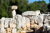
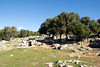
The above images may not be of the site on this page, but were taken nearby. They are loaded from Flickr so please click on them for image credits.
Click here to see more info for this site
Nearby sites
Click here to view sites on an interactive map of the areaKey: Red: member's photo, Blue: 3rd party photo, Yellow: other image, Green: no photo - please go there and take one, Grey: site destroyed
Download sites to:
KML (Google Earth)
GPX (GPS waypoints)
CSV (Garmin/Navman)
CSV (Excel)
To unlock full downloads you need to sign up as a Contributory Member. Otherwise downloads are limited to 50 sites.
Turn off the page maps and other distractions
Nearby sites listing. In the following links * = Image available
1.8km S 174° Torre d'en Gaumés* Ancient Village or Settlement
2.4km S 179° Ses Roques Lises* Chambered Tomb
2.4km S 181° Sa Comerma de sa Garita* Ancient Temple
4.0km NNW 339° Turmaden d'es Capita* Broch or Nuraghe
4.3km E 101° Na Patarrà Cave or Rock Shelter
4.4km E 99° Torralba d'en Salord* Ancient Village or Settlement
4.5km SE 142° Torrelbenc Vell* Ancient Village or Settlement
4.7km ESE 104° Torralbet* Chambered Tomb
4.8km SSE 150° Son Rotger* Ancient Village or Settlement
4.8km E 90° Llumena* Chambered Tomb
5.1km SE 128° Torre Llisà Vell* Ancient Temple
5.2km E 89° L'Argentina (Occidental) naveta* Chambered Tomb
5.3km ESE 111° Cotaina d'En Carreres Ancient Village or Settlement
5.4km WNW 289° Santa Mònica* Broch or Nuraghe
5.5km SE 132° So Na Caçana* Ancient Village or Settlement
5.7km E 94° L'Argentina (Oriental) naveta* Chambered Tomb
6.2km WNW 286° Sa Pedrola d'en Magi* Broch or Nuraghe
6.3km SE 136° Lloc Nou des Fasser* Broch or Nuraghe
6.3km WNW 297° Binicodrell de Darrera* Broch or Nuraghe
6.4km WNW 293° Es Mestall* Broch or Nuraghe
6.6km SE 124° Cotaina De Can Rabassó* Chambered Tomb
6.7km W 279° Sant Agustí Vell* Ancient Village or Settlement
6.7km E 100° Rafal Rubí naveta* Chambered Tomb
6.9km WNW 299° Binicodrell Nou* Standing Stone (Menhir)
7.0km ESE 112° Tanques De Montplè Chambered Tomb
View more nearby sites and additional images


 We would like to know more about this location. Please feel free to add a brief description and any relevant information in your own language.
 Wir möchten mehr über diese Stätte erfahren. Bitte zögern Sie nicht, eine kurze Beschreibung und relevante Informationen in Deutsch hinzuzufügen.
 Nous aimerions en savoir encore un peu sur les lieux. S'il vous plaît n'hesitez pas à ajouter une courte description et tous les renseignements pertinents dans votre propre langue.
 Quisieramos informarnos un poco más de las lugares. No dude en añadir una breve descripción y otros datos relevantes en su propio idioma.