


<< Our Photo Pages >> Qasr Usaykhim - Stone Fort or Dun in Jordan
Submitted by mrcrow on Wednesday, 13 March 2024 Page Views: 954
Roman, Greek and ClassicalSite Name: Qasr Usaykhim Alternative Name: Qasr AseikhinCountry: Jordan Type: Stone Fort or Dun
Nearest Town: Azraq
Latitude: 31.945900N Longitude: 36.952200E
Condition:
| 5 | Perfect |
| 4 | Almost Perfect |
| 3 | Reasonable but with some damage |
| 2 | Ruined but still recognisable as an ancient site |
| 1 | Pretty much destroyed, possibly visible as crop marks |
| 0 | No data. |
| -1 | Completely destroyed |
| 5 | Superb |
| 4 | Good |
| 3 | Ordinary |
| 2 | Not Good |
| 1 | Awful |
| 0 | No data. |
| 5 | Can be driven to, probably with disabled access |
| 4 | Short walk on a footpath |
| 3 | Requiring a bit more of a walk |
| 2 | A long walk |
| 1 | In the middle of nowhere, a nightmare to find |
| 0 | No data. |
| 5 | co-ordinates taken by GPS or official recorded co-ordinates |
| 4 | co-ordinates scaled from a detailed map |
| 3 | co-ordinates scaled from a bad map |
| 2 | co-ordinates of the nearest village |
| 1 | co-ordinates of the nearest town |
| 0 | no data |
Internal Links:
External Links:
I have visited· I would like to visit
mrcrow visited on 1st Jan 0000 - their rating: Cond: 2 Amb: 5 Access: 1
")
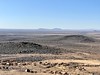
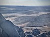
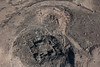
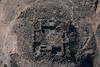
Located about nine miles to the northeast of Azraq in the Harrat al Sham, the Black Desert, is Qasr Usaykhim.
Just to the south of the hill is Wadi Usaykhim, with "cells" nearby of small basalt walls still used by modern Bedouin to contain livestock. Just due north of the hill, within a mile, are two desert kites easily seen on Google Earth imagery, but quite difficult to see at ground level.
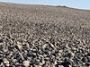
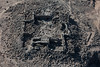
The fort is estimated to be from the first century CE based off of potsherds (1), potsherds which are still visible above ground in the fort and just outside its walls. Others have found flint tools on the hilltop within the hilltop walls suggesting an earlier occupation (2); the Bronze Age has been suggested. The hilltop basalt walls are believed to be older than the Roman fort.
It's possible, with skill, to drive with a 2WD sedan up to the hilltop, but a standard 4WD truck with its clearance is recommended. The site is sign-posted from the highway to the northwest. Off the main highway, the secondary road has severe potholes. Off the secondary road to the hilltop are large rocks, sand, and a quite uneven surface.
Sources:
(1) Wikipedia - Qasr Usaykhim
(2) Al-Khouri and G. C. Infranca: The Archaeological Site of Qasr al-Uşaykhim
You may be viewing yesterday's version of this page. To see the most up to date information please register for a free account.
")
")
")
")
Do not use the above information on other web sites or publications without permission of the contributor.
Nearby Images from Flickr
The above images may not be of the site on this page, but were taken nearby. They are loaded from Flickr so please click on them for image credits.
Click here to see more info for this site
Nearby sites
Click here to view sites on an interactive map of the areaKey: Red: member's photo, Blue: 3rd party photo, Yellow: other image, Green: no photo - please go there and take one, Grey: site destroyed
Download sites to:
KML (Google Earth)
GPX (GPS waypoints)
CSV (Garmin/Navman)
CSV (Excel)
To unlock full downloads you need to sign up as a Contributory Member. Otherwise downloads are limited to 50 sites.
Turn off the page maps and other distractions
Nearby sites listing. In the following links * = Image available
16.1km WSW 253° Azraq Geoglyph* Stone Circle
17.7km SW 225° Ayn Qasiyya Burials Natural Stone / Erratic / Other Natural Feature
25.2km SE 136° Jebel Qurma Petroglyphs* Rock Art
27.3km SW 233° Azraq Desert Kite* Misc. Earthwork
27.3km SW 229° Qasr Uweinid* Stone Fort or Dun
38.8km NNW 344° Qasr Deir Al-Kahf* Stone Fort or Dun
43.6km N 6° Jawa* Ancient Village or Settlement
51.6km NE 37° Khirbet al-Ja’bariya* Hillfort
56.9km WSW 247° Kharaneh IV* Ancient Village or Settlement
61.1km WNW 286° Qasr al-Hallabat* Stone Fort or Dun
69.3km NW 308° Umm el-Jimal* Ancient Village or Settlement
77.4km NW 325° Bosra* Ancient Village or Settlement
77.8km SSW 208° Qasr Tuba* Ancient Palace
92.2km W 273° Ain Ghazal* Ancient Village or Settlement
94.2km NE 53° Tulul al-Ghusayn* Hillfort
94.8km NNW 341° QanaWat Temple of Helios* Ancient Temple
95.2km NNW 341° QanaWat Nympheum* Holy Well or Sacred Spring
96.0km W 271° Jordan Archaeological Museum* Museum
96.0km W 271° Amman Citadel* Ancient Village or Settlement
97.4km W 271° Amman.* NOT SET
100.3km E 79° Khirbet Abu al-Husayn* Ancient Village or Settlement
100.8km W 265° Tall al-Umayri* Ancient Village or Settlement
106.4km WSW 248° Khirbat Al-Mudayna* Ancient Village or Settlement
106.5km WNW 291° Jerash* Ancient Village or Settlement
109.5km WSW 243° Umm Al-Rasas* Ancient Village or Settlement
View more nearby sites and additional images


 We would like to know more about this location. Please feel free to add a brief description and any relevant information in your own language.
 Wir möchten mehr über diese Stätte erfahren. Bitte zögern Sie nicht, eine kurze Beschreibung und relevante Informationen in Deutsch hinzuzufügen.
 Nous aimerions en savoir encore un peu sur les lieux. S'il vous plaît n'hesitez pas à ajouter une courte description et tous les renseignements pertinents dans votre propre langue.
 Quisieramos informarnos un poco más de las lugares. No dude en añadir una breve descripción y otros datos relevantes en su propio idioma.