


<< Our Photo Pages >> Hama. - Ancient Village or Settlement in Syria
Submitted by AlexHunger on Tuesday, 21 November 2006 Page Views: 6676
Multi-periodSite Name: Hama. Alternative Name: HamathCountry: Syria Type: Ancient Village or Settlement
Nearest Town: Hama Nearest Village: Hama
Latitude: 35.136158N Longitude: 36.749382E
Condition:
| 5 | Perfect |
| 4 | Almost Perfect |
| 3 | Reasonable but with some damage |
| 2 | Ruined but still recognisable as an ancient site |
| 1 | Pretty much destroyed, possibly visible as crop marks |
| 0 | No data. |
| -1 | Completely destroyed |
| 5 | Superb |
| 4 | Good |
| 3 | Ordinary |
| 2 | Not Good |
| 1 | Awful |
| 0 | No data. |
| 5 | Can be driven to, probably with disabled access |
| 4 | Short walk on a footpath |
| 3 | Requiring a bit more of a walk |
| 2 | A long walk |
| 1 | In the middle of nowhere, a nightmare to find |
| 0 | No data. |
| 5 | co-ordinates taken by GPS or official recorded co-ordinates |
| 4 | co-ordinates scaled from a detailed map |
| 3 | co-ordinates scaled from a bad map |
| 2 | co-ordinates of the nearest village |
| 1 | co-ordinates of the nearest town |
| 0 | no data |
Be the first person to rate this site - see the 'Contribute!' box in the right hand menu.
Internal Links:
External Links:
")
The ancient settlement of Hamath was occupied from the early Neolithic to the Iron Age. Remains from the Chalcolithic era have been uncovered by Danish archaeologists on the mount on which the former citadel once stood. The excavation took place between 1931 and 1938 under the direction of Harald Ingholt. The stratigraphy is very generalised, which makes detailed comparison to other sites difficult. Level M (6 m or 20 ft thick) contained both white ware— vessels made from lime-plaster— and true pottery. It may be contemporary with Ras Shamra V (6000-5000 BC). The overlying level L dates to the Chalcolithic Halaf-period.
The site is inside a tight curve of the Orontes, which made it relatively easy to defend, and was the original place of the settlement; later on, as the town grew beyond it, the mound became the military center of Hama.
The Amorite people colonized the area during the third millennium B.C. The Amorites came from Mari on the River Euphrates, some 250 miles to the east of Hama, and they colonized many parts of what is now Syria and Iraq.
Around 1500 BC, Hama enjoyed great prosperity; during this time it was an Amorite dependency of the Mittannian Empire, the imperial base of which was situated in the deserts of northeastern Syria.
Virtually nothing is known of Hama during the latter part of the second millennium BC: the Mittannians were overthrown by the Hittie forces, who gained control of most of Syria, including Hama, after the Battle of Kadesh, fought against the Egyptians (under Ramses II) near Hims in 1285. After Hittie power waned the city came under Assyrian control. Then as the power of the Assyrians also began to decline, the Aramaean peoples moved in. The Aramaeans were a nomadic group that originated from the Syrian desert and gradually moved into the more fertile areas of western Syria over the course of the closing decades of the second millennium B.C.
By the turn of the millennium Hama was the capital of a prosperous Aramaean and neo-Hittie kingdom known as Hamath, which traded extensively, particularly with what is now Israel. The Aramaean and neo-Hittie peoples lived comparatively peacefully, co-existing with other states in the region, such as Carchemish. The most significant of all the Aramaean states was Damascus, which became the leader of the federation of Aramaic states, of which Hamath was a member. Gradually Aramaic became the most widely used language of the Near East.
More at Wikipedia
You may be viewing yesterday's version of this page. To see the most up to date information please register for a free account.
")
Do not use the above information on other web sites or publications without permission of the contributor.
Nearby Images from Flickr


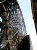
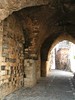
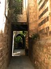
The above images may not be of the site on this page, but were taken nearby. They are loaded from Flickr so please click on them for image credits.
Click here to see more info for this site
Nearby sites
Click here to view sites on an interactive map of the areaKey: Red: member's photo, Blue: 3rd party photo, Yellow: other image, Green: no photo - please go there and take one, Grey: site destroyed
Download sites to:
KML (Google Earth)
GPX (GPS waypoints)
CSV (Garmin/Navman)
CSV (Excel)
To unlock full downloads you need to sign up as a Contributory Member. Otherwise downloads are limited to 50 sites.
Turn off the page maps and other distractions
Nearby sites listing. In the following links * = Image available
319m S 170° Hama National Museum Museum
35.1km SSE 162° Qatna Ancient Village or Settlement
42.5km NW 319° Syrian tell* Ancient Village or Settlement
45.4km NW 316° Apamea* Ancient Village or Settlement
51.3km WSW 244° Baitokaike Temple of Zeus* Ancient Temple
67.6km SSW 198° Kadesh Tell* Ancient Village or Settlement
69.5km SW 215° Beit Djallou Temple of Nemesis Ancient Temple
73.7km N 3° Ebla Palace* Ancient Palace
73.8km N 3° Ebla.* Ancient Village or Settlement
73.8km N 3° Ebla Temple of Ishtar* Ancient Temple
77.4km WNW 284° Sukas Ancient Village or Settlement
77.8km NNE 13° Ur-Schu Ancient Village or Settlement
81.2km WSW 251° Amrit Meghaziles* Chambered Cairn
81.4km SSW 206° Brissa Stele Sculptured Stone
82.3km WSW 252° Amrit Sacred Spring Holy Well or Sacred Spring
83.5km SSW 198° Qamouat el-Hermel Marker Stone
83.8km WSW 251° Tartus Museum Museum
85.1km N 3° Neirab* Ancient Village or Settlement
86.9km WSW 249° Arados* Ancient Village or Settlement
93.6km SSW 202° Deir Mar Maroun Ancient Village or Settlement
94.6km NNW 341° Karkara Stone Fort or Dun
101.6km WNW 301° Ugarit Temples* Ancient Temple
101.8km WNW 301° Ugarit Palace* Ancient Palace
101.9km WNW 301° Ugarit* Ancient Village or Settlement
103.2km SW 218° Sfire Temples Ancient Temple
View more nearby sites and additional images


 We would like to know more about this location. Please feel free to add a brief description and any relevant information in your own language.
 Wir möchten mehr über diese Stätte erfahren. Bitte zögern Sie nicht, eine kurze Beschreibung und relevante Informationen in Deutsch hinzuzufügen.
 Nous aimerions en savoir encore un peu sur les lieux. S'il vous plaît n'hesitez pas à ajouter une courte description et tous les renseignements pertinents dans votre propre langue.
 Quisieramos informarnos un poco más de las lugares. No dude en añadir una breve descripción y otros datos relevantes en su propio idioma.