


<< Text Pages >> Yesemek - Ancient Mine, Quarry or other Industry in Turkey
Submitted by AlexHunger on Sunday, 10 December 2006 Page Views: 3720
Multi-periodSite Name: YesemekCountry: Turkey
NOTE: This site is 15.418 km away from the location you searched for.
Type: Ancient Mine, Quarry or other Industry
Nearest Town: Osmaniye Nearest Village: Yesemek
Latitude: 36.904170N Longitude: 36.745378E
Condition:
| 5 | Perfect |
| 4 | Almost Perfect |
| 3 | Reasonable but with some damage |
| 2 | Ruined but still recognisable as an ancient site |
| 1 | Pretty much destroyed, possibly visible as crop marks |
| 0 | No data. |
| -1 | Completely destroyed |
| 5 | Superb |
| 4 | Good |
| 3 | Ordinary |
| 2 | Not Good |
| 1 | Awful |
| 0 | No data. |
| 5 | Can be driven to, probably with disabled access |
| 4 | Short walk on a footpath |
| 3 | Requiring a bit more of a walk |
| 2 | A long walk |
| 1 | In the middle of nowhere, a nightmare to find |
| 0 | No data. |
| 5 | co-ordinates taken by GPS or official recorded co-ordinates |
| 4 | co-ordinates scaled from a detailed map |
| 3 | co-ordinates scaled from a bad map |
| 2 | co-ordinates of the nearest village |
| 1 | co-ordinates of the nearest town |
| 0 | no data |
Internal Links:
External Links:
I have visited· I would like to visit
davidmorgan would like to visit
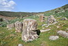
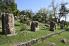
The ancient Yesemek sculpture workshop and basalt stone quarry cover took up an area of 300 by 400 meters under the Hittite rule, probably during the reign of Suppiluliuma I (1375-1335 BCE) and under the Sam'al kingdom. About 300 finished and unfinished statues have been discovered. Historians believe that the masons and sculptors were probably carried off by the Assyrians to work on their own monuments.
On the UNESCO World Heritage tentative list.
You may be viewing yesterday's version of this page. To see the most up to date information please register for a free account.
Do not use the above information on other web sites or publications without permission of the contributor.
Nearby Images from Flickr
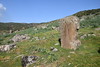
The above images may not be of the site on this page, but were taken nearby. They are loaded from Flickr so please click on them for image credits.
Click here to see more info for this site
Nearby sites
Click here to view sites on an interactive map of the areaKey: Red: member's photo, Blue: 3rd party photo, Yellow: other image, Green: no photo - please go there and take one, Grey: site destroyed
Download sites to:
KML (Google Earth)
GPX (GPS waypoints)
CSV (Garmin/Navman)
CSV (Excel)
To unlock full downloads you need to sign up as a Contributory Member. Otherwise downloads are limited to 50 sites.
Turn off the page maps and other distractions
Nearby sites listing. In the following links * = Image available
22.7km NNW 345° Sam'al* Ancient Village or Settlement
34.0km NNE 22° Coba Höyük* Ancient Village or Settlement
40.3km NNE 30° Birtlan Ancient Village or Settlement
44.8km ESE 120° Oylum Hoyuk Ancient Village or Settlement
46.0km SSE 165° Ain Dara* Ancient Temple
53.1km NNE 29° Domuztepe Ancient Village or Settlement
56.1km W 278° Issus (Cilicia) Ancient Village or Settlement
57.5km S 169° Bit-Agusi Ancient Village or Settlement
58.1km WNW 302° Castabala Ancient Village or Settlement
61.7km NW 315° Karatepe Ancient Village or Settlement
77.6km NNE 12° Marash* Ancient Village or Settlement
80.1km SSW 204° Tell Ta’yinat* Ancient Village or Settlement
80.7km SSW 204° Alalakh* Ancient Village or Settlement
84.7km WNW 298° Anazarbus Ancient Village or Settlement
84.7km SSE 155° Tel al-Abar 3 Ancient Village or Settlement
85.9km SSE 155° Aleppo Museum* Museum
86.3km SSE 155° Djade al-Mughara Ancient Village or Settlement
86.6km W 260° Aegeae Ancient Village or Settlement
86.8km SSE 154° Aleppo Tell* Ancient Village or Settlement
87.1km NE 56° Yavuzeli Dolmen* Burial Chamber or Dolmen
89.5km W 277° King Muwatalli Relief Rock Art
91.1km SSW 214° Antakya Museum Museum
91.8km ENE 78° Sehzade Höyük Ancient Village or Settlement
93.8km SSW 214° Antioch on the Orontes Ancient Village or Settlement
99.9km W 274° Mopsuestia* Ancient Village or Settlement
View more nearby sites and additional images


 We would like to know more about this location. Please feel free to add a brief description and any relevant information in your own language.
 Wir möchten mehr über diese Stätte erfahren. Bitte zögern Sie nicht, eine kurze Beschreibung und relevante Informationen in Deutsch hinzuzufügen.
 Nous aimerions en savoir encore un peu sur les lieux. S'il vous plaît n'hesitez pas à ajouter une courte description et tous les renseignements pertinents dans votre propre langue.
 Quisieramos informarnos un poco más de las lugares. No dude en añadir una breve descripción y otros datos relevantes en su propio idioma.