


<< Our Photo Pages >> Qasr Tuba - Ancient Palace in Jordan
Submitted by mrcrow on Monday, 01 April 2024 Page Views: 30
Multi-periodSite Name: Qasr TubaCountry: Jordan
NOTE: This site is 15.558 km away from the location you searched for.
Type: Ancient Palace
Latitude: 31.326100N Longitude: 36.570900E
Condition:
| 5 | Perfect |
| 4 | Almost Perfect |
| 3 | Reasonable but with some damage |
| 2 | Ruined but still recognisable as an ancient site |
| 1 | Pretty much destroyed, possibly visible as crop marks |
| 0 | No data. |
| -1 | Completely destroyed |
| 5 | Superb |
| 4 | Good |
| 3 | Ordinary |
| 2 | Not Good |
| 1 | Awful |
| 0 | No data. |
| 5 | Can be driven to, probably with disabled access |
| 4 | Short walk on a footpath |
| 3 | Requiring a bit more of a walk |
| 2 | A long walk |
| 1 | In the middle of nowhere, a nightmare to find |
| 0 | No data. |
| 5 | co-ordinates taken by GPS or official recorded co-ordinates |
| 4 | co-ordinates scaled from a detailed map |
| 3 | co-ordinates scaled from a bad map |
| 2 | co-ordinates of the nearest village |
| 1 | co-ordinates of the nearest town |
| 0 | no data |
Internal Links:
External Links:
I have visited· I would like to visit
mrcrow has visited here
")
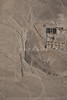
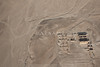
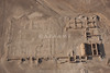
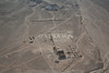
Qasr Tuba is an unfinished Umayyad complex which was started in 743CE. The Qasr is in an isolated location beside a wadi in the Eastern Jordanian desert. Consisting of mostly mud bricks, a few structures survive. The largest, mostly intact buildings are in the northwest part of the complex. They have barrel-vaulted ceilings made of brick. Surrounding walls of the complex survive to some degree.
Wikipedia - Qasr Tuba
You may be viewing yesterday's version of this page. To see the most up to date information please register for a free account.
")
")
Do not use the above information on other web sites or publications without permission of the contributor.
Nearby Images from Flickr
![Qasr Tuba [Qasr et-Tuba]](https://farm9.static.flickr.com/8894/17242206550_ed9faf009c_t.jpg)

The above images may not be of the site on this page, but were taken nearby. They are loaded from Flickr so please click on them for image credits.
Click here to see more info for this site
Nearby sites
Click here to view sites on an interactive map of the areaKey: Red: member's photo, Blue: 3rd party photo, Yellow: other image, Green: no photo - please go there and take one, Grey: site destroyed
Download sites to:
KML (Google Earth)
GPX (GPS waypoints)
CSV (Garmin/Navman)
CSV (Excel)
To unlock full downloads you need to sign up as a Contributory Member. Otherwise downloads are limited to 50 sites.
Turn off the page maps and other distractions
Nearby sites listing. In the following links * = Image available
49.5km NNW 341° Kharaneh IV* Ancient Village or Settlement
53.3km NNE 17° Qasr Uweinid* Stone Fort or Dun
54.4km NNE 15° Azraq Desert Kite* Misc. Earthwork
61.2km NNE 23° Ayn Qasiyya Burials Natural Stone / Erratic / Other Natural Feature
64.7km WNW 288° Umm Al-Rasas* Ancient Village or Settlement
67.6km NNE 18° Azraq Geoglyph* Stone Circle
69.3km WNW 295° Khirbat Al-Mudayna* Ancient Village or Settlement
73.8km NE 46° Jebel Qurma Petroglyphs* Rock Art
74.6km SW 233° Big Circle J1 Misc. Earthwork
77.2km WNW 284° Khirbet Ataruz Ancient Village or Settlement
77.4km W 269° Wadi Walla Roman mile stone* Marker Stone
77.5km W 263° Khirbat Iskandar* Ancient Village or Settlement
77.8km NNE 28° Qasr Usaykhim* Stone Fort or Dun
77.9km W 260° Ader.* Standing Stone (Menhir)
79.3km SW 230° Big Circle J2 Misc. Earthwork
79.4km W 266° Qasr Ar-Rabba* Ancient Temple
80.2km W 275° Redjom el A'abed* Ancient Village or Settlement
84.2km W 259° Al Karak castle * Hillfort
84.8km WSW 245° Dhat Ras* Ancient Temple
85.4km WNW 301° Madaba (Jordan)* Ancient Village or Settlement
85.6km WNW 301° Madaba Mosaic Map* Misc. Earthwork
86.0km WNW 301° Adeihmeh* Burial Chamber or Dolmen
88.3km NNW 345° Qasr al-Hallabat* Stone Fort or Dun
88.5km NW 313° Tall al-Umayri* Ancient Village or Settlement
90.2km WNW 294° Khajar Mansub* Standing Stone (Menhir)
View more nearby sites and additional images


 We would like to know more about this location. Please feel free to add a brief description and any relevant information in your own language.
 Wir möchten mehr über diese Stätte erfahren. Bitte zögern Sie nicht, eine kurze Beschreibung und relevante Informationen in Deutsch hinzuzufügen.
 Nous aimerions en savoir encore un peu sur les lieux. S'il vous plaît n'hesitez pas à ajouter une courte description et tous les renseignements pertinents dans votre propre langue.
 Quisieramos informarnos un poco más de las lugares. No dude en añadir una breve descripción y otros datos relevantes en su propio idioma.