

<< Our Photo Pages >> Qasr al-Hallabat - Stone Fort or Dun in Jordan
Submitted by mrcrow on Friday, 29 March 2024 Page Views: 53
Iron Age and Later PrehistorySite Name: Qasr al-HallabatCountry: Jordan
NOTE: This site is 6.747 km away from the location you searched for.
Type: Stone Fort or Dun
Nearest Town: Zarqa Nearest Village: Qasser Al-Hallabat Al-Gharbi
Latitude: 32.092900N Longitude: 36.328000E
Condition:
| 5 | Perfect |
| 4 | Almost Perfect |
| 3 | Reasonable but with some damage |
| 2 | Ruined but still recognisable as an ancient site |
| 1 | Pretty much destroyed, possibly visible as crop marks |
| 0 | No data. |
| -1 | Completely destroyed |
| 5 | Superb |
| 4 | Good |
| 3 | Ordinary |
| 2 | Not Good |
| 1 | Awful |
| 0 | No data. |
| 5 | Can be driven to, probably with disabled access |
| 4 | Short walk on a footpath |
| 3 | Requiring a bit more of a walk |
| 2 | A long walk |
| 1 | In the middle of nowhere, a nightmare to find |
| 0 | No data. |
| 5 | co-ordinates taken by GPS or official recorded co-ordinates |
| 4 | co-ordinates scaled from a detailed map |
| 3 | co-ordinates scaled from a bad map |
| 2 | co-ordinates of the nearest village |
| 1 | co-ordinates of the nearest town |
| 0 | no data |
Internal Links:
External Links:
I have visited· I would like to visit
mrcrow has visited here
")
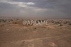
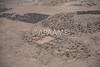
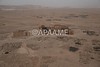
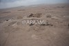
Qasr al-Hallabat is the remains of an Umayyad palace sitting on the site of an older Roman fort. The Roman fort was built sometime in the 2nd or 3rd century CE, but was demolished in the 8th century by the Umayyads to repurpose the site as a more comfortable palace. Materials of the older Roman fort were integrated into the Umayyad palace. There are reused basalt blocks with Greek inscriptions in the walls of the Qasr. Mosaics at the site are in fair shape. Recently, the mosque outside the walls of the Qasr was reconstructed from the rubble.
Parking and facilities are available at the site; as is a small, but wonderful, museum. In 2023 admission to the site was free. From the parking area and museum to the complex there is a walk of about 900 feet.
For more information on the site, please see links provided below.
Wikipedia - Qasr al-Hallabat
Archnet - Qasr al-Hallabat
Qaṣr Al Hallābāt Museum
You may be viewing yesterday's version of this page. To see the most up to date information please register for a free account.
")
")
")
")
Do not use the above information on other web sites or publications without permission of the contributor.
Nearby Images from Flickr

The above images may not be of the site on this page, but were taken nearby. They are loaded from Flickr so please click on them for image credits.
Click here to see more info for this site
Nearby sites
Click here to view sites on an interactive map of the areaKey: Red: member's photo, Blue: 3rd party photo, Yellow: other image, Green: no photo - please go there and take one, Grey: site destroyed
Download sites to:
KML (Google Earth)
GPX (GPS waypoints)
CSV (Garmin/Navman)
CSV (Excel)
To unlock full downloads you need to sign up as a Contributory Member. Otherwise downloads are limited to 50 sites.
Turn off the page maps and other distractions
Nearby sites listing. In the following links * = Image available
26.3km N 8° Umm el-Jimal* Ancient Village or Settlement
35.2km WSW 251° Ain Ghazal* Ancient Village or Settlement
39.2km S 170° Kharaneh IV* Ancient Village or Settlement
40.2km WSW 248° Amman Citadel* Ancient Village or Settlement
40.2km WSW 248° Jordan Archaeological Museum* Museum
41.6km WSW 248° Amman.* NOT SET
46.0km WNW 297° Jerash* Ancient Village or Settlement
48.3km ESE 116° Azraq Geoglyph* Stone Circle
48.4km WSW 239° Tall al-Umayri* Ancient Village or Settlement
49.4km NNE 17° Bosra* Ancient Village or Settlement
49.5km SE 131° Azraq Desert Kite* Misc. Earthwork
51.4km SE 132° Qasr Uweinid* Stone Fort or Dun
52.4km ENE 66° Qasr Deir Al-Kahf* Stone Fort or Dun
54.5km ESE 122° Ayn Qasiyya Burials Natural Stone / Erratic / Other Natural Feature
58.5km WSW 239° Hesbon* Burial Chamber or Dolmen
61.1km ESE 105° Qasr Usaykhim* Stone Fort or Dun
61.4km NW 317° Jdeta* Burial Chamber or Dolmen
62.8km NNW 341° Tal al-Ashari Barrow Cemetery
65.4km SW 231° Madaba Mosaic Map* Misc. Earthwork
65.4km SW 230° Madaba (Jordan)* Ancient Village or Settlement
65.6km SW 231° Adeihmeh* Burial Chamber or Dolmen
67.4km WSW 244° Rawdah* Burial Chamber or Dolmen
68.6km SW 215° Khirbat Al-Mudayna* Ancient Village or Settlement
68.8km NW 319° Irbid* Ancient Village or Settlement
69.0km ENE 67° Jawa* Ancient Village or Settlement
View more nearby sites and additional images


 We would like to know more about this location. Please feel free to add a brief description and any relevant information in your own language.
 Wir möchten mehr über diese Stätte erfahren. Bitte zögern Sie nicht, eine kurze Beschreibung und relevante Informationen in Deutsch hinzuzufügen.
 Nous aimerions en savoir encore un peu sur les lieux. S'il vous plaît n'hesitez pas à ajouter une courte description et tous les renseignements pertinents dans votre propre langue.
 Quisieramos informarnos un poco más de las lugares. No dude en añadir una breve descripción y otros datos relevantes en su propio idioma.