


<< Text Pages >> Seleukeia Temple of Zeus - Ancient Temple in Turkey
Submitted by AlexHunger on Sunday, 07 October 2007 Page Views: 5174
Roman, Greek and ClassicalSite Name: Seleukeia Temple of Zeus Alternative Name: Seleukeia in Pieria temple of ZeusCountry: Turkey
NOTE: This site is 0.753 km away from the location you searched for.
Type: Ancient Temple
Nearest Town: Antakya Nearest Village: Samandag
Latitude: 36.120240N Longitude: 35.924014E
Condition:
| 5 | Perfect |
| 4 | Almost Perfect |
| 3 | Reasonable but with some damage |
| 2 | Ruined but still recognisable as an ancient site |
| 1 | Pretty much destroyed, possibly visible as crop marks |
| 0 | No data. |
| -1 | Completely destroyed |
| 5 | Superb |
| 4 | Good |
| 3 | Ordinary |
| 2 | Not Good |
| 1 | Awful |
| 0 | No data. |
| 5 | Can be driven to, probably with disabled access |
| 4 | Short walk on a footpath |
| 3 | Requiring a bit more of a walk |
| 2 | A long walk |
| 1 | In the middle of nowhere, a nightmare to find |
| 0 | No data. |
| 5 | co-ordinates taken by GPS or official recorded co-ordinates |
| 4 | co-ordinates scaled from a detailed map |
| 3 | co-ordinates scaled from a bad map |
| 2 | co-ordinates of the nearest village |
| 1 | co-ordinates of the nearest town |
| 0 | no data |
Internal Links:
External Links:
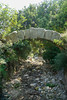
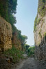
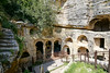
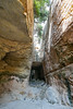
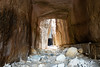
Ancient Temple in Hatay Province, Turkey
Foundations of Temple of Zeus which measures 34 metres by 16 metres and had 12 by 6 columns. The blocks were used for nearby fortifications.
The Hellenistic city was founded by Seleucid kings.
You may be viewing yesterday's version of this page. To see the most up to date information please register for a free account.
Do not use the above information on other web sites or publications without permission of the contributor.
Nearby Images from Flickr
The above images may not be of the site on this page, but were taken nearby. They are loaded from Flickr so please click on them for image credits.
Click here to see more info for this site
Nearby sites
Click here to view sites on an interactive map of the areaKey: Red: member's photo, Blue: 3rd party photo, Yellow: other image, Green: no photo - please go there and take one, Grey: site destroyed
Download sites to:
KML (Google Earth)
GPX (GPS waypoints)
CSV (Garmin/Navman)
CSV (Excel)
To unlock full downloads you need to sign up as a Contributory Member. Otherwise downloads are limited to 50 sites.
Turn off the page maps and other distractions
Nearby sites listing. In the following links * = Image available
9.5km SE 143° Al Mina Ancient Village or Settlement
23.6km ENE 68° Antioch on the Orontes Ancient Village or Settlement
25.9km ENE 64° Antakya Museum Museum
43.0km ENE 71° Tell Ta’yinat* Ancient Village or Settlement
43.2km ENE 72° Alalakh* Ancient Village or Settlement
47.9km ESE 115° Karkara Stone Fort or Dun
58.8km SSW 192° Ugarit Temples* Ancient Temple
59.0km SSW 193° Ugarit* Ancient Village or Settlement
59.0km SSW 192° Ugarit Palace* Ancient Palace
70.0km NW 313° Magarsus Ancient Village or Settlement
73.4km N 350° Aegeae Ancient Village or Settlement
82.5km ESE 107° Neirab* Ancient Village or Settlement
86.4km ESE 114° Ebla Palace* Ancient Palace
86.5km ESE 114° Ebla.* Ancient Village or Settlement
86.5km ESE 114° Ebla Temple of Ishtar* Ancient Temple
88.0km SSE 151° Apamea* Ancient Village or Settlement
89.8km ENE 70° Bit-Agusi Ancient Village or Settlement
90.3km SSE 149° Syrian tell* Ancient Village or Settlement
90.5km S 180° Sukas Ancient Village or Settlement
95.5km ENE 63° Ain Dara* Ancient Temple
96.5km N 10° Issus (Cilicia) Ancient Village or Settlement
96.9km NNW 344° Mopsuestia* Ancient Village or Settlement
98.3km ESE 110° Ur-Schu Ancient Village or Settlement
99.6km N 351° King Muwatalli Relief Rock Art
110.3km E 84° Tel al-Abar 3 Ancient Village or Settlement
View more nearby sites and additional images


 We would like to know more about this location. Please feel free to add a brief description and any relevant information in your own language.
 Wir möchten mehr über diese Stätte erfahren. Bitte zögern Sie nicht, eine kurze Beschreibung und relevante Informationen in Deutsch hinzuzufügen.
 Nous aimerions en savoir encore un peu sur les lieux. S'il vous plaît n'hesitez pas à ajouter une courte description et tous les renseignements pertinents dans votre propre langue.
 Quisieramos informarnos un poco más de las lugares. No dude en añadir una breve descripción y otros datos relevantes en su propio idioma.