

<< Our Photo Pages >> Khirbat Iskandar - Ancient Village or Settlement in Jordan
Submitted by Motist on Friday, 30 June 2006 Page Views: 4404
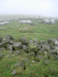
Multi-periodSite Name: Khirbat IskandarCountry: Jordan
NOTE: This site is 10.205 km away from the location you searched for.
Type: Ancient Village or Settlement
Latitude: 31.241539N Longitude: 35.761301E
Condition:
| 5 | Perfect |
| 4 | Almost Perfect |
| 3 | Reasonable but with some damage |
| 2 | Ruined but still recognisable as an ancient site |
| 1 | Pretty much destroyed, possibly visible as crop marks |
| 0 | No data. |
| -1 | Completely destroyed |
| 5 | Superb |
| 4 | Good |
| 3 | Ordinary |
| 2 | Not Good |
| 1 | Awful |
| 0 | No data. |
| 5 | Can be driven to, probably with disabled access |
| 4 | Short walk on a footpath |
| 3 | Requiring a bit more of a walk |
| 2 | A long walk |
| 1 | In the middle of nowhere, a nightmare to find |
| 0 | No data. |
| 5 | co-ordinates taken by GPS or official recorded co-ordinates |
| 4 | co-ordinates scaled from a detailed map |
| 3 | co-ordinates scaled from a bad map |
| 2 | co-ordinates of the nearest village |
| 1 | co-ordinates of the nearest town |
| 0 | no data |
Be the first person to rate this site - see the 'Contribute!' box in the right hand menu.
Internal Links:
External Links:
")
Coordinates converted from old Israel datum: 222601 E, 1072510 N.
You may be viewing yesterday's version of this page. To see the most up to date information please register for a free account.
Do not use the above information on other web sites or publications without permission of the contributor.
Nearby Images from Flickr

The above images may not be of the site on this page, but were taken nearby. They are loaded from Flickr so please click on them for image credits.
Click here to see more info for this site
Nearby sites
Click here to view sites on an interactive map of the areaKey: Red: member's photo, Blue: 3rd party photo, Yellow: other image, Green: no photo - please go there and take one, Grey: site destroyed
Download sites to:
KML (Google Earth)
GPX (GPS waypoints)
CSV (Garmin/Navman)
CSV (Excel)
To unlock full downloads you need to sign up as a Contributory Member. Otherwise downloads are limited to 50 sites.
Turn off the page maps and other distractions
Nearby sites listing. In the following links * = Image available
3.9km NW 325° Qasr Ar-Rabba* Ancient Temple
4.4km S 176° Ader.* Standing Stone (Menhir)
7.4km N 357° Wadi Walla Roman mile stone* Marker Stone
8.8km SW 220° Al Karak castle * Hillfort
16.1km N 349° Redjom el A'abed* Ancient Village or Settlement
18.6km W 275° Zahrat adh-Dhra’ 2 Ancient Village or Settlement
21.7km W 274° Bab edh-Dhra Ancient Village or Settlement
26.8km S 179° Dhat Ras* Ancient Temple
28.5km N 4° Khirbet Ataruz Ancient Village or Settlement
30.8km S 190° Khirbet Al-Tannur* Ancient Temple
32.5km NNE 28° Umm Al-Rasas* Ancient Village or Settlement
37.6km S 189° Khirbat Al-Dharieh* Ancient Temple
38.5km NNW 340° Mukawir* Hillfort
39.4km WNW 282° Masada* Hillfort
40.3km SSE 154° Big Circle J1 Misc. Earthwork
40.7km WSW 256° Mesad Zohar* Hillfort
41.1km NNE 20° Khirbat Al-Mudayna* Ancient Village or Settlement
42.7km NW 305° Ein Gedi ancient Synagogue* Ancient Temple
42.9km NW 305° Tel Goren* Ancient Village or Settlement
43.4km NW 305° Ein Gedi Chalcolithic Temple* Ancient Temple
43.9km WNW 292° Cave of the Treasure in wadi Mishmar* Cave or Rock Shelter
45.0km SSE 158° Big Circle J2 Misc. Earthwork
46.1km N 353° el-Mareighat* Burial Chamber or Dolmen
46.1km N 353° South of Khajar Mansub Menhirs & Dolmens* Chambered Tomb
46.2km N 353° Khajar Mansub* Standing Stone (Menhir)
View more nearby sites and additional images


 We would like to know more about this location. Please feel free to add a brief description and any relevant information in your own language.
 Wir möchten mehr über diese Stätte erfahren. Bitte zögern Sie nicht, eine kurze Beschreibung und relevante Informationen in Deutsch hinzuzufügen.
 Nous aimerions en savoir encore un peu sur les lieux. S'il vous plaît n'hesitez pas à ajouter une courte description et tous les renseignements pertinents dans votre propre langue.
 Quisieramos informarnos un poco más de las lugares. No dude en añadir una breve descripción y otros datos relevantes en su propio idioma.