


<< Our Photo Pages >> Arados - Ancient Village or Settlement in Syria
Submitted by AlexHunger on Sunday, 24 June 2007 Page Views: 5296
Multi-periodSite Name: Arados Alternative Name: Arwad, Arvad, Arpad, Arphad, Antiochia in PieriaCountry: Syria Type: Ancient Village or Settlement
Nearest Town: Tartous Nearest Village: Arwad
Latitude: 34.856380N Longitude: 35.858396E
Condition:
| 5 | Perfect |
| 4 | Almost Perfect |
| 3 | Reasonable but with some damage |
| 2 | Ruined but still recognisable as an ancient site |
| 1 | Pretty much destroyed, possibly visible as crop marks |
| 0 | No data. |
| -1 | Completely destroyed |
| 5 | Superb |
| 4 | Good |
| 3 | Ordinary |
| 2 | Not Good |
| 1 | Awful |
| 0 | No data. |
| 5 | Can be driven to, probably with disabled access |
| 4 | Short walk on a footpath |
| 3 | Requiring a bit more of a walk |
| 2 | A long walk |
| 1 | In the middle of nowhere, a nightmare to find |
| 0 | No data. |
| 5 | co-ordinates taken by GPS or official recorded co-ordinates |
| 4 | co-ordinates scaled from a detailed map |
| 3 | co-ordinates scaled from a bad map |
| 2 | co-ordinates of the nearest village |
| 1 | co-ordinates of the nearest town |
| 0 | no data |
Be the first person to rate this site - see the 'Contribute!' box in the right hand menu.
Internal Links:
External Links:
")
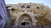
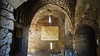
Phoenician settlement on island in Syria. The island was settled in the early 2nd millennium BC by the Phoenicians.
You may be viewing yesterday's version of this page. To see the most up to date information please register for a free account.
")
")
")
Do not use the above information on other web sites or publications without permission of the contributor.
Nearby Images from Flickr
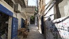
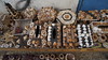
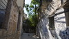
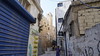
The above images may not be of the site on this page, but were taken nearby. They are loaded from Flickr so please click on them for image credits.
Click here to see more info for this site
Nearby sites
Click here to view sites on an interactive map of the areaKey: Red: member's photo, Blue: 3rd party photo, Yellow: other image, Green: no photo - please go there and take one, Grey: site destroyed
Download sites to:
KML (Google Earth)
GPX (GPS waypoints)
CSV (Garmin/Navman)
CSV (Excel)
To unlock full downloads you need to sign up as a Contributory Member. Otherwise downloads are limited to 50 sites.
Turn off the page maps and other distractions
Nearby sites listing. In the following links * = Image available
4.4km NNE 25° Tartus Museum Museum
6.3km NE 45° Amrit Meghaziles* Chambered Cairn
6.6km NNE 25° Amrit Sacred Spring Holy Well or Sacred Spring
36.3km ENE 77° Baitokaike Temple of Zeus* Ancient Temple
45.7km S 184° Tripoli (Lebanon)* Ancient Village or Settlement
49.3km ESE 122° Beit Djallou Temple of Nemesis Ancient Temple
50.4km N 7° Sukas Ancient Village or Settlement
53.8km SSE 160° Sfire Temples Ancient Temple
61.8km SE 133° Brissa Stele Sculptured Stone
62.1km S 184° Amioun Necropolis Rock Cut Tomb
63.1km S 181° Qasr Naous West Temple Ancient Temple
63.1km S 181° Qasr Naous Temple Ancient Temple
64.3km S 173° Monastery of Saint Anthony of Qozhaya Ancient Temple
65.3km S 183° Bziza Temple Ancient Temple
69.0km ESE 119° Kadesh Tell* Ancient Village or Settlement
73.4km SE 140° Deir Mar Maroun Ancient Village or Settlement
73.5km SE 131° Qamouat el-Hermel Marker Stone
80.7km NE 38° Apamea* Ancient Village or Settlement
82.8km NE 40° Syrian tell* Ancient Village or Settlement
83.2km N 355° Ugarit Palace* Ancient Palace
83.2km N 355° Ugarit* Ancient Village or Settlement
83.2km S 177° Aphaca* Holy Well or Sacred Spring
83.3km N 355° Ugarit Temples* Ancient Temple
83.7km SSW 193° The monastery of Saint Antonio Ancient Palace
84.1km SSW 193° Byblos* Ancient Village or Settlement
View more nearby sites and additional images


 We would like to know more about this location. Please feel free to add a brief description and any relevant information in your own language.
 Wir möchten mehr über diese Stätte erfahren. Bitte zögern Sie nicht, eine kurze Beschreibung und relevante Informationen in Deutsch hinzuzufügen.
 Nous aimerions en savoir encore un peu sur les lieux. S'il vous plaît n'hesitez pas à ajouter une courte description et tous les renseignements pertinents dans votre propre langue.
 Quisieramos informarnos un poco más de las lugares. No dude en añadir una breve descripción y otros datos relevantes en su propio idioma.