


<< Text Pages >> Dubbah Breika - Ancient Village or Settlement in Syria
Submitted by davidmorgan on Sunday, 21 November 2010 Page Views: 3202
Multi-periodSite Name: Dubbah Breika Alternative Name: DobboCountry: Syria
NOTE: This site is 6.822 km away from the location you searched for.
Type: Ancient Village or Settlement
Latitude: 33.031105N Longitude: 35.863473E
Condition:
| 5 | Perfect |
| 4 | Almost Perfect |
| 3 | Reasonable but with some damage |
| 2 | Ruined but still recognisable as an ancient site |
| 1 | Pretty much destroyed, possibly visible as crop marks |
| 0 | No data. |
| -1 | Completely destroyed |
| 5 | Superb |
| 4 | Good |
| 3 | Ordinary |
| 2 | Not Good |
| 1 | Awful |
| 0 | No data. |
| 5 | Can be driven to, probably with disabled access |
| 4 | Short walk on a footpath |
| 3 | Requiring a bit more of a walk |
| 2 | A long walk |
| 1 | In the middle of nowhere, a nightmare to find |
| 0 | No data. |
| 5 | co-ordinates taken by GPS or official recorded co-ordinates |
| 4 | co-ordinates scaled from a detailed map |
| 3 | co-ordinates scaled from a bad map |
| 2 | co-ordinates of the nearest village |
| 1 | co-ordinates of the nearest town |
| 0 | no data |
Be the first person to rate this site - see the 'Contribute!' box in the right hand menu.
Internal Links:
External Links:
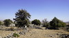
Ancient Settlement in Syria.
Dubbah Breika hill is an archaeological site located at about 1 km to the south of Breika village in Swaida Province. It is surrounded by a huge fence where the archaeological finds dating back to different historical ages: the Greek, Aramaic, Nabataean and Roman were uncovered. The site was named Dobbo in the past and controlled the trade routes in that region. Syrian Arab New Agency.
You may be viewing yesterday's version of this page. To see the most up to date information please register for a free account.
Do not use the above information on other web sites or publications without permission of the contributor.
Nearby Images from Flickr
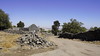
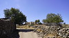
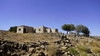
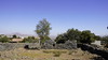

The above images may not be of the site on this page, but were taken nearby. They are loaded from Flickr so please click on them for image credits.
Click here to see more info for this site
Nearby sites
Click here to view sites on an interactive map of the areaKey: Red: member's photo, Blue: 3rd party photo, Yellow: other image, Green: no photo - please go there and take one, Grey: site destroyed
Download sites to:
KML (Google Earth)
GPX (GPS waypoints)
CSV (Garmin/Navman)
CSV (Excel)
To unlock full downloads you need to sign up as a Contributory Member. Otherwise downloads are limited to 50 sites.
Turn off the page maps and other distractions
Nearby sites listing. In the following links * = Image available
14.8km SSW 203° Rujm el-Hiri* Stone Circle
17.0km SSW 199° Dolmen field near Natur on the Golan Heights* Barrow Cemetery
17.5km SW 218° Gamla Dolmen field* Burial Chamber or Dolmen
17.7km SW 218° The ancient city of Gamla* Ancient Village or Settlement
22.5km NNW 336° Dolmen field in Odem forest on The Golan Heights* Artificial Mound
23.7km NW 308° Engraved dolmen near Kibbutz Shamir* Burial Chamber or Dolmen
25.6km WSW 238° Bethsaida* Ancient Village or Settlement
27.6km W 267° Tel Hatzor* Artificial Mound
28.9km NNW 327° Banyas* Ancient Temple
30.2km SW 221° Kursi National Park* Ancient Village or Settlement
31.2km NW 321° Tel Dan Ancient Village or Settlement
31.3km NW 321° Tel Dan Ancient Village or Settlement
32.5km WNW 287° Tel Kadesh Naftali* Ancient Village or Settlement
33.2km SW 214° Wadi Ein Gev Ancient Village or Settlement
33.2km SW 214° NEG II Prehistoric Village* Ancient Village or Settlement
33.2km W 265° Naburiya synagogue in Biriya Forest* Ancient Temple
33.9km SW 214° Sussita* Ancient Village or Settlement
36.7km NW 314° Tel Abel Beth Maacah* Ancient Village or Settlement
37.4km NNE 12° Tell Ramad Ancient Village or Settlement
39.2km WSW 237° Dalmanutha* Ancient Village or Settlement
39.3km WSW 246° Hukok* Ancient Temple
41.5km SW 225° Hammat Tiberias* Ancient Village or Settlement
41.9km W 272° Baram Synagogue* Ancient Temple
42.0km WSW 256° Crescent-shaped monument near Shefer* Artificial Mound
43.6km SW 218° Sea of Galilee Cairn* Cairn
View more nearby sites and additional images


 We would like to know more about this location. Please feel free to add a brief description and any relevant information in your own language.
 Wir möchten mehr über diese Stätte erfahren. Bitte zögern Sie nicht, eine kurze Beschreibung und relevante Informationen in Deutsch hinzuzufügen.
 Nous aimerions en savoir encore un peu sur les lieux. S'il vous plaît n'hesitez pas à ajouter une courte description et tous les renseignements pertinents dans votre propre langue.
 Quisieramos informarnos un poco más de las lugares. No dude en añadir una breve descripción y otros datos relevantes en su propio idioma.