


<< Text Pages >> Khirbet Ataruz - Ancient Village or Settlement in Jordan
Submitted by davidmorgan on Sunday, 17 October 2010 Page Views: 8567
Multi-periodSite Name: Khirbet Ataruz Alternative Name: AtarothCountry: Jordan
NOTE: This site is 0.734 km away from the location you searched for.
Type: Ancient Village or Settlement
Nearest Town: Dhiban
Latitude: 31.497409N Longitude: 35.782385E
Condition:
| 5 | Perfect |
| 4 | Almost Perfect |
| 3 | Reasonable but with some damage |
| 2 | Ruined but still recognisable as an ancient site |
| 1 | Pretty much destroyed, possibly visible as crop marks |
| 0 | No data. |
| -1 | Completely destroyed |
| 5 | Superb |
| 4 | Good |
| 3 | Ordinary |
| 2 | Not Good |
| 1 | Awful |
| 0 | No data. |
| 5 | Can be driven to, probably with disabled access |
| 4 | Short walk on a footpath |
| 3 | Requiring a bit more of a walk |
| 2 | A long walk |
| 1 | In the middle of nowhere, a nightmare to find |
| 0 | No data. |
| 5 | co-ordinates taken by GPS or official recorded co-ordinates |
| 4 | co-ordinates scaled from a detailed map |
| 3 | co-ordinates scaled from a bad map |
| 2 | co-ordinates of the nearest village |
| 1 | co-ordinates of the nearest town |
| 0 | no data |
Be the first person to rate this site - see the 'Contribute!' box in the right hand menu.
Internal Links:
External Links:
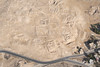
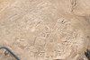
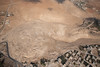
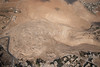
Ancient Settlement in Jordan.
An important Moabite religious and political centre dating from the late 2nd millennium BCE.
Note: 3,000-year-old Moabite temple unearthed near Dhiban - see comment.
You may be viewing yesterday's version of this page. To see the most up to date information please register for a free account.
Do not use the above information on other web sites or publications without permission of the contributor.
Nearby Images from Flickr

The above images may not be of the site on this page, but were taken nearby. They are loaded from Flickr so please click on them for image credits.
Click here to see more info for this site
Nearby sites
Click here to view sites on an interactive map of the areaKey: Red: member's photo, Blue: 3rd party photo, Yellow: other image, Green: no photo - please go there and take one, Grey: site destroyed
Download sites to:
KML (Google Earth)
GPX (GPS waypoints)
CSV (Garmin/Navman)
CSV (Excel)
To unlock full downloads you need to sign up as a Contributory Member. Otherwise downloads are limited to 50 sites.
Turn off the page maps and other distractions
Nearby sites listing. In the following links * = Image available
13.1km E 88° Umm Al-Rasas* Ancient Village or Settlement
13.7km SSW 202° Redjom el A'abed* Ancient Village or Settlement
15.7km NE 49° Khirbat Al-Mudayna* Ancient Village or Settlement
16.9km WNW 297° Mukawir* Hillfort
19.0km NNW 335° el-Mareighat* Burial Chamber or Dolmen
19.0km NNW 335° South of Khajar Mansub Menhirs & Dolmens* Chambered Tomb
19.0km NNW 336° Khajar Mansub* Standing Stone (Menhir)
21.2km S 187° Wadi Walla Roman mile stone* Marker Stone
24.4km N 3° Madaba (Jordan)* Ancient Village or Settlement
24.5km N 3° Madaba Mosaic Map* Misc. Earthwork
24.8km N 2° Adeihmeh* Burial Chamber or Dolmen
25.6km S 190° Qasr Ar-Rabba* Ancient Temple
26.6km NNW 347° Dolmens at Wadi Jadid* Burial Chamber or Dolmen
28.5km S 184° Khirbat Iskandar* Ancient Village or Settlement
32.9km S 183° Ader.* Standing Stone (Menhir)
33.8km SW 217° Zahrat adh-Dhra’ 2 Ancient Village or Settlement
35.8km N 2° Hesbon* Burial Chamber or Dolmen
36.0km SW 221° Bab edh-Dhra Ancient Village or Settlement
36.0km SSW 192° Al Karak castle * Hillfort
37.2km W 264° Ein Gedi ancient Synagogue* Ancient Temple
37.5km W 264° Tel Goren* Ancient Village or Settlement
37.5km W 265° Ein Gedi Chalcolithic Temple* Ancient Temple
38.1km NNW 346° Rawdah* Burial Chamber or Dolmen
38.2km NNW 333° Tulaylat al-Ghassul Ancient Village or Settlement
40.9km NW 312° Qumran* Ancient Village or Settlement
View more nearby sites and additional images


 We would like to know more about this location. Please feel free to add a brief description and any relevant information in your own language.
 Wir möchten mehr über diese Stätte erfahren. Bitte zögern Sie nicht, eine kurze Beschreibung und relevante Informationen in Deutsch hinzuzufügen.
 Nous aimerions en savoir encore un peu sur les lieux. S'il vous plaît n'hesitez pas à ajouter une courte description et tous les renseignements pertinents dans votre propre langue.
 Quisieramos informarnos un poco más de las lugares. No dude en añadir una breve descripción y otros datos relevantes en su propio idioma.