


<< Text Pages >> The monastery of Saint Antonio - Ancient Palace in Lebanon
Submitted by Archiphoenic on Saturday, 05 November 2016 Page Views: 1088
Early Medieval (Dark Age)Site Name: The monastery of Saint Antonio Alternative Name: St. Anthony, Byblos, Lebanon, Phoenician, PhoeniciaCountry: Lebanon
NOTE: This site is 0.101 km away from the location you searched for.
Type: Ancient Palace
Nearest Town: Byblos Nearest Village: Beithabak
Latitude: 34.123000N Longitude: 35.651930E
Condition:
| 5 | Perfect |
| 4 | Almost Perfect |
| 3 | Reasonable but with some damage |
| 2 | Ruined but still recognisable as an ancient site |
| 1 | Pretty much destroyed, possibly visible as crop marks |
| 0 | No data. |
| -1 | Completely destroyed |
| 5 | Superb |
| 4 | Good |
| 3 | Ordinary |
| 2 | Not Good |
| 1 | Awful |
| 0 | No data. |
| 5 | Can be driven to, probably with disabled access |
| 4 | Short walk on a footpath |
| 3 | Requiring a bit more of a walk |
| 2 | A long walk |
| 1 | In the middle of nowhere, a nightmare to find |
| 0 | No data. |
| 5 | co-ordinates taken by GPS or official recorded co-ordinates |
| 4 | co-ordinates scaled from a detailed map |
| 3 | co-ordinates scaled from a bad map |
| 2 | co-ordinates of the nearest village |
| 1 | co-ordinates of the nearest town |
| 0 | no data |
Internal Links:
External Links:
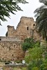
St. Anthony's monastery in a stone mountain cliff, dating from the beginning of the 9th century. It is hard to see its small entrance doors which are typical of monasteries in the area.
These were designed to prevent Ottoman cavaliers from bursting inside with their horses. This has been a stronghold location of the Christian faith surviving in the Middle East since the death of the Christ.
You may be viewing yesterday's version of this page. To see the most up to date information please register for a free account.
Do not use the above information on other web sites or publications without permission of the contributor.
Nearby Images from Flickr

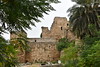
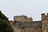
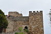
The above images may not be of the site on this page, but were taken nearby. They are loaded from Flickr so please click on them for image credits.
Click here to see more info for this site
Nearby sites
Click here to view sites on an interactive map of the areaKey: Red: member's photo, Blue: 3rd party photo, Yellow: other image, Green: no photo - please go there and take one, Grey: site destroyed
Download sites to:
KML (Google Earth)
GPX (GPS waypoints)
CSV (Garmin/Navman)
CSV (Excel)
To unlock full downloads you need to sign up as a Contributory Member. Otherwise downloads are limited to 50 sites.
Turn off the page maps and other distractions
Nearby sites listing. In the following links * = Image available
604m WSW 241° Byblos* Ancient Village or Settlement
11.5km ESE 109° Machnaka Ancient Temple
15.3km ESE 104° Yanouh Ancient Temple
19.1km SE 142° Qal'at Faqra Ancient Temple
19.3km SSW 195° Nahr el-Kalb Steles Rock Art
22.6km NE 44° Bziza Temple Ancient Temple
23.7km E 94° Aphaca* Holy Well or Sacred Spring
24.5km NE 37° Amioun Necropolis Rock Cut Tomb
25.6km NE 44° Qasr Naous West Temple Ancient Temple
25.7km NE 44° Qasr Naous Temple Ancient Temple
28.3km SSW 208° Beirut* Ancient Village or Settlement
29.2km SSW 212° American University Museum Museum
30.0km SSW 205° Beirut National Museum* Museum
30.2km S 190° Beit Meri Temple of Baal Marqod Ancient Temple
32.4km ENE 57° Monastery of Saint Anthony of Qozhaya Ancient Temple
36.3km SE 131° Hosn Niha Temple D Ancient Temple
36.4km SE 131° Hosn Niha Temple C Ancient Temple
38.3km SE 131° Nihata Temple of Atargatis Ancient Temple
38.3km SE 131° Nihata Temple of Hadaranes Ancient Temple
39.3km NNE 24° Tripoli (Lebanon)* Ancient Village or Settlement
48.6km NE 50° Sfire Temples Ancient Temple
52.3km ESE 105° Baalbek Quarry* Ancient Mine, Quarry or other Industry
52.5km ESE 104° Baalbek Temple * Ancient Temple
56.2km SSW 196° Chhim Ancient Temple
56.6km SSE 164° Dakoue Temple Ancient Temple
View more nearby sites and additional images


 We would like to know more about this location. Please feel free to add a brief description and any relevant information in your own language.
 Wir möchten mehr über diese Stätte erfahren. Bitte zögern Sie nicht, eine kurze Beschreibung und relevante Informationen in Deutsch hinzuzufügen.
 Nous aimerions en savoir encore un peu sur les lieux. S'il vous plaît n'hesitez pas à ajouter une courte description et tous les renseignements pertinents dans votre propre langue.
 Quisieramos informarnos un poco más de las lugares. No dude en añadir una breve descripción y otros datos relevantes en su propio idioma.