


<< Our Photo Pages >> Hiram's Tomb - Rock Cut Tomb in Lebanon
Submitted by AlexHunger on Wednesday, 17 October 2007 Page Views: 9117
Multi-periodSite Name: Hiram's Tomb Alternative Name: Qabr HiramCountry: Lebanon
NOTE: This site is 2.925 km away from the location you searched for.
Type: Rock Cut Tomb
Nearest Town: Tyre Nearest Village: Al Janub
Latitude: 33.233330N Longitude: 35.283330E
Condition:
| 5 | Perfect |
| 4 | Almost Perfect |
| 3 | Reasonable but with some damage |
| 2 | Ruined but still recognisable as an ancient site |
| 1 | Pretty much destroyed, possibly visible as crop marks |
| 0 | No data. |
| -1 | Completely destroyed |
| 5 | Superb |
| 4 | Good |
| 3 | Ordinary |
| 2 | Not Good |
| 1 | Awful |
| 0 | No data. |
| 5 | Can be driven to, probably with disabled access |
| 4 | Short walk on a footpath |
| 3 | Requiring a bit more of a walk |
| 2 | A long walk |
| 1 | In the middle of nowhere, a nightmare to find |
| 0 | No data. |
| 5 | co-ordinates taken by GPS or official recorded co-ordinates |
| 4 | co-ordinates scaled from a detailed map |
| 3 | co-ordinates scaled from a bad map |
| 2 | co-ordinates of the nearest village |
| 1 | co-ordinates of the nearest town |
| 0 | no data |
Internal Links:
External Links:
")
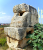
Assyrian or Persian era rock cut tomb with massoned stone Cenotaph popularly attributed to the biblical king Hiram.
You may be viewing yesterday's version of this page. To see the most up to date information please register for a free account.
")
")
")
")
Do not use the above information on other web sites or publications without permission of the contributor.
Nearby Images from Flickr


The above images may not be of the site on this page, but were taken nearby. They are loaded from Flickr so please click on them for image credits.
Click here to see more info for this site
Nearby sites
Click here to view sites on an interactive map of the areaKey: Red: member's photo, Blue: 3rd party photo, Yellow: other image, Green: no photo - please go there and take one, Grey: site destroyed
Download sites to:
KML (Google Earth)
GPX (GPS waypoints)
CSV (Garmin/Navman)
CSV (Excel)
To unlock full downloads you need to sign up as a Contributory Member. Otherwise downloads are limited to 50 sites.
Turn off the page maps and other distractions
Nearby sites listing. In the following links * = Image available
5.1km WNW 300° Ras el-Ain Reservoir Holy Well or Sacred Spring
9.3km WNW 297° Tyre.* Ancient Village or Settlement
22.4km SW 227° Milkashtart Temple Ancient Temple
23.0km SW 219° Shlomi ,1,600 year-old kiln* Ancient Mine, Quarry or other Industry
23.5km SSW 201° Manot cave* Cave or Rock Shelter
24.3km SSE 150° Baram Synagogue* Ancient Temple
26.4km ESE 120° Tel Kadesh Naftali* Ancient Village or Settlement
26.6km SW 220° Tel Achziv* Ancient Village or Settlement
27.8km E 84° Tel Abel Beth Maacah* Ancient Village or Settlement
28.6km SSW 208° Tel Kabri* Ancient Palace
28.9km S 170° PEKI''IN old Synagogue * Ancient Temple
31.5km S 182° Khirbet Mehoz* Ancient Village or Settlement
33.1km SE 141° Naburiya synagogue in Biriya Forest* Ancient Temple
34.3km E 87° Tel Dan Ancient Village or Settlement
34.3km E 87° Tel Dan Ancient Village or Settlement
35.3km SSE 158° Crescent-shaped monument near Shefer* Artificial Mound
35.4km S 190° HaYonim cave* Cave or Rock Shelter
35.8km SE 132° Tel Hatzor* Artificial Mound
36.3km ESE 102° Engraved dolmen near Kibbutz Shamir* Burial Chamber or Dolmen
37.2km S 182° Hilazon Tachtit* Cave or Rock Shelter
37.3km NNE 13° Sidon* Ancient Village or Settlement
37.4km SSW 197° Ahihud Ancient Settlement* Ancient Village or Settlement
38.0km ENE 62° Kawkaba Phoenician Grotto Rock Cut Tomb
38.3km E 87° Banyas* Ancient Temple
39.8km SSW 210° Ancient Acre* Ancient Village or Settlement
View more nearby sites and additional images


 We would like to know more about this location. Please feel free to add a brief description and any relevant information in your own language.
 Wir möchten mehr über diese Stätte erfahren. Bitte zögern Sie nicht, eine kurze Beschreibung und relevante Informationen in Deutsch hinzuzufügen.
 Nous aimerions en savoir encore un peu sur les lieux. S'il vous plaît n'hesitez pas à ajouter une courte description et tous les renseignements pertinents dans votre propre langue.
 Quisieramos informarnos un poco más de las lugares. No dude en añadir una breve descripción y otros datos relevantes en su propio idioma.