


<< Text Pages >> Rachel's Tomb - Ancient Temple in Palestine
Submitted by Andy B on Thursday, 25 February 2010 Page Views: 5380
Roman, Greek and ClassicalSite Name: Rachel's Tomb Alternative Name: Bilal Ibn Ribah mosque, Dome of RachelCountry: Palestine Type: Ancient Temple
Nearest Town: Bethlehem
Latitude: 31.720447N Longitude: 35.202475E
Condition:
| 5 | Perfect |
| 4 | Almost Perfect |
| 3 | Reasonable but with some damage |
| 2 | Ruined but still recognisable as an ancient site |
| 1 | Pretty much destroyed, possibly visible as crop marks |
| 0 | No data. |
| -1 | Completely destroyed |
| 5 | Superb |
| 4 | Good |
| 3 | Ordinary |
| 2 | Not Good |
| 1 | Awful |
| 0 | No data. |
| 5 | Can be driven to, probably with disabled access |
| 4 | Short walk on a footpath |
| 3 | Requiring a bit more of a walk |
| 2 | A long walk |
| 1 | In the middle of nowhere, a nightmare to find |
| 0 | No data. |
| 5 | co-ordinates taken by GPS or official recorded co-ordinates |
| 4 | co-ordinates scaled from a detailed map |
| 3 | co-ordinates scaled from a bad map |
| 2 | co-ordinates of the nearest village |
| 1 | co-ordinates of the nearest town |
| 0 | no data |
Be the first person to rate this site - see the 'Contribute!' box in the right hand menu.
Internal Links:
External Links:
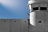
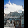
Ancient Temple in the West Bank. Rachel's Tomb is located at the northern entrance of the West Bank city of Bethlehem, along Route 60.
Traditions regarding the site as the tomb of the biblical matriarch Rachel at this location date back to the beginning of the 4th-century AD. It is considered the third holiest site in Judaism and the symbol of the return of the Jewish People to its ancient homeland. Historically, Muslims also associated the tomb with that of the biblical figure. In recent years however the site has been claimed to be a mosque built at the time of the Arab conquest. Others, relying on biblical texts, place her burial site north-east of Jerusalem in the vicinity of biblical Ramah, modern day ar-Ram.
In 1154 al-Idrisi writes “The tomb is covered by 12 stones and above is a dome vaulted over with stone.” Benjamin of Tudela (1169-71) mentions 11 stones upon the grave covered by a cupola resting on four columns “and all the Jews that pass by carve their names upon the stones of the pillar.” Petachiah of Regensburg explains that the 11 stones represented the tribes of Israel, excluding Benjamin, since Rachel had died during his birth. All were marble, with that of Jacob on top.” In the 14-century, Antony of Cremona referred to the cenotaph as “the most wonderful tomb that I shall ever see. I don not think that with 20 pairs of oxen it would be possible to extract or move one of its stones.” It was described by Franciscan pilgrim Nicolas of Poggibonsi (1346-50) as being 7 feet high and enclosed by a rounded tomb with three gates.
Read more at Wikipedia
You may be viewing yesterday's version of this page. To see the most up to date information please register for a free account.
Do not use the above information on other web sites or publications without permission of the contributor.
Nearby Images from Flickr


The above images may not be of the site on this page, but were taken nearby. They are loaded from Flickr so please click on them for image credits.
Click here to see more info for this site
Nearby sites
Click here to view sites on an interactive map of the areaKey: Red: member's photo, Blue: 3rd party photo, Yellow: other image, Green: no photo - please go there and take one, Grey: site destroyed
Download sites to:
KML (Google Earth)
GPX (GPS waypoints)
CSV (Garmin/Navman)
CSV (Excel)
To unlock full downloads you need to sign up as a Contributory Member. Otherwise downloads are limited to 50 sites.
Turn off the page maps and other distractions
Nearby sites listing. In the following links * = Image available
3.5km NNE 22° Talpiot Tomb Rock Cut Tomb
6.6km NNE 29° Hezekiah's Tunnel* Ancient Mine, Quarry or other Industry
6.7km NNE 28° City of David* Ancient Village or Settlement
7.1km NNE 26° Temple Mount* Ancient Temple
7.1km SSE 149° Herodion* Ancient Palace
7.8km NNE 24° 2000 year old stone fragment in Jerusalem* Marker Stone
8.3km NNW 338° Tel Motza* Ancient Village or Settlement
10.1km NNW 327° Motza Neolithic City* Ancient Village or Settlement
10.5km NNE 20° Shuafat road Chalcolithic period site* Ancient Village or Settlement
19.4km W 259° 2,000-year-old ‘Emperor’s Road’ near Beit Shemesh* Ancient Trackway
19.7km W 278° Tel Beth-Shemesh* Artificial Mound
20.0km W 262° Ramat Beit Shemesh ritual baths* Ancient Village or Settlement
23.2km WSW 250° Khirbat Ethri* Ancient Village or Settlement
23.3km W 263° Khirbet Qeiyafa* Ancient Village or Settlement
23.4km SSW 202° Cave of the Patriarchs Rock Cut Tomb
24.0km WNW 303° Emmaus Ancient Village or Settlement
24.0km WSW 247° Tel Burgin* Ancient Village or Settlement
24.4km E 84° Qumran* Ancient Village or Settlement
25.3km W 265° Tel Azeqa Ancient Village or Settlement
26.4km ENE 57° Jericho* Ancient Village or Settlement
28.7km WSW 250° Tel Goded Ancient Village or Settlement
30.8km NE 54° The Gilgal associated peacefully with Joshua Stone Circle
31.0km WNW 300° Tel Gezer* Ancient Village or Settlement
31.7km WSW 246° Bet Guvrin-Maresha National Park* Ancient Village or Settlement
32.7km WSW 252° Tel Burna* Ancient Village or Settlement
View more nearby sites and additional images


 We would like to know more about this location. Please feel free to add a brief description and any relevant information in your own language.
 Wir möchten mehr über diese Stätte erfahren. Bitte zögern Sie nicht, eine kurze Beschreibung und relevante Informationen in Deutsch hinzuzufügen.
 Nous aimerions en savoir encore un peu sur les lieux. S'il vous plaît n'hesitez pas à ajouter une courte description et tous les renseignements pertinents dans votre propre langue.
 Quisieramos informarnos un poco más de las lugares. No dude en añadir una breve descripción y otros datos relevantes en su propio idioma.